Pahasapa Formation
The Pahasapa Formation is a geological unit of primarily limestone and dolomite[3] that is exposed in the Black Hills of South Dakota and northeastern Wyoming, and underlies parts of Nebraska, in the United States.[4] Also referred to as the Pahasapa Limestone (especially in older publications and outside South Dakota), this unit is analogous to the Madison Limestone,[1] the Lodgepole Limestone,[5] and the Burlington Limestone,[6] other Mississippian-aged limestones and dolomites in the midwestern United States. Some recent literature has grouped stretches of the Pahasapa into the Madison Group.[5] The formation is of local importance, as it contains the Madison aquifer, and two of the ten longest caves in the world.[7]
| Pahasapa Formation | |
|---|---|
| Stratigraphic range: Mississippian[1] | |
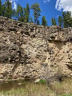
 An exposure of the cliff forming Pahasapa west of Rapid City, along Nemo Road. The karstic tendencies of the unit are clearly visible in the pitting of the face. | |
| Type | Formation |
| Underlies | Minnelusa Formation[2] |
| Overlies | Englewood Formation[2] |
| Thickness | 225-500 ft[1] |
| Lithology | |
| Primary | Limestone |
| Other | Dolomite, dolomitic limestone |
| Location | |
| Region | South Dakota, Wyoming, Nebraska |
| Country | United States |
| Type section | |
| Named for | the Dakota people's name for the Black Hills[1] |
| Named by | Darton, in 1901 |
Lithology
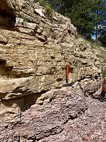
The Pahasapa consists mainly of grey massive limestone and dolomite.[1] The limestone has been classified as primary dolo-sparitic, with some micrite,[8] using the Folk classification, and as skeletal wackestone using the Dunham classification.[5] The central Black Hills Pahasapa is more dominantly dolomite, while the outer fringes tend more strongly limestone.[8] In the upper sections, it can consist of limestone interbedded with dolomites, or simply evaporite dolomites.[9]
The Pahasapa has a gradational, conformable contact with the Devonian Englewood Formation beneath it, and an unconformable contact Pennsylvanian Minnelusa Formation.[1]
Geologic history
During the Mississippian, the sea gradually transgressed over the current United States Mid-west, depositing significant limestone sequences across the region. The Pahasapa is one of a suite of geologically analogous formations that cover much of the central US and were deposited by the same sea.[9] Within this large-scale sea level rise, there were many smaller cycles of transgression and regression, which are expressed in stratigraphic facies packages within the larger framework of the formation.[5]
The formation is marine in origin, and bedding planes, cross-stratification, and fossil assemblages indicate that it was deposited in high-energy, relatively shallow water.[8] The formation lacks reef-building organisms, but variable dip directions in the deposits indicate it may have been deposited on a marine bank.[8]
Due to the widespread nature of the dolomitization of the Pahasapa in the central Black Hills, but the sparse alteration outside of this area, the alteration is interpreted to have occurred early in the formation's history, before consolidation, while the newly deposited limestone was still close to sea-level.[8] This selective alteration also supported the interpretation of a marine bank deposition, with the central Pahasapa making up the central marine bank.[8]

Fossil content
As the Pahasapa is a marine limestone, the fossils it contains are primarily brachiopods and scattered corals,[1] along with some crinoid plates, gastropods, and bryozoans.[8] Corals are chiefly Syringopora, and are found generally found near the gradational contact with the Englewood Formation. Also found were the molluscs Bellerophon, Euomphalus, and the marine invertebrates Pentremites.[1] Burrows, a trace fossil left by species working the sediment before it lithified, are also common in the lower sections of the formation.[10]
In the sections of the Pahasapa that have been dolomitized, many of the fossils have been destroyed due to recrystallization of the calcium carbonate, and those that remain have a distinctive "sugary" appearance.[10]
Features
All of the caves in the Black Hills are developed in the Pahasapa.[8] Two of the most notable of these caves are Wind Cave, the seventh largest cave in the world,[7] and Jewel Cave, the third largest cave in the world.[7] Wind Cave is known for its calcite box work, a distinctive speleothem, and its passages that intersect with paleocave fill, indicating Mississippian-era caves that developed and then were flooded with sediment.[10]
The Madison aquifer, the most important aquifer in South Dakota, is contained within the upper sections of the Pahasapa formation.[11]
See also
Citations
- Darton, N.H. (1901). "Preliminary description of the geology and water resources of the southern half of the Black Hills and adjoining regions in South Dakota and Wyoming" (PDF). U.S. Geological Survey Annual Report. 21 (pt. 4): 489. Bibcode:1901JG......9..732H. doi:10.1086/620971. Retrieved 11 June 2021.
- Feldman, R.M.; Heimlich, R.A. (1980). The Black Hills Field Guide. Dubuque: Kendell/Hunt Publishing Co. p. 190.
- Butler, R.J.; Battin, R.L.; Winston, G.O. (1955). "Lithologic correlation of middle and lower Paleozoic rocks". North Dakota Geological Society Field Conference Guidebook. 3: 38–42.
- Condra, G.E.; Schramm, E.F.; Lugn, A.L. (1931). "Deep Wells of Nebraska". Nebraska Geological Survey Bulletin. 2nd Series (4).
- Petty, David M. (2003). "Sequence Stratigraphy of the Pahasapa Formation (Madison Group) in the Northeastern Black Hills: Insights from Regional Correlations". The Mountain Geologist. 40 (2): 19.
- Darton, N.H. and Paige, Sidney (1925). Central Black Hills folio, South Dakota (Map). 1:125,000. Geologic Atlas of the United States. United States Geological Survey. p. GF-219.
{{cite map}}: CS1 maint: multiple names: authors list (link) - Gulden, Bob (2021-10-04). "Worlds longest caves". Geo2 Committee on Long and Deep Caves. National Speleological Society (NSS). Retrieved 2021-10-08.
- Najjar, Abdullatif (1971). Dolomitized Pahasapa Limestone (Mississippian), northeastern sector of the Black Hills, South Dakota, petrography and geological setting. Missouri S&T: Master's Thesis. Retrieved 2 November 2022.
- Andrichuk, J.M. (1955). "Mississippian Madison group stratigraphy and sedimentation in Wyoming and southern Montana". American Association of Petroleum Geologists. 39 (11): 2170.
- KellerLynn, K. (2009). Wind Cave National Park Geologic Resources Inventory Report, Natural Resource Report NPS/NRPC/GRD/NRR-2009/087. Denver: National Park Service. pp. 14–15, 29–30.
- Strobel, M.L.; Davis, A.D.; Sawyer, J.F.; Rahn, P.H.; Webb, C.J.; Naus, C.A. (2000). "Hydrology of the Black Hills". South Dakota School of Mines and Technology Bulletin. 20: 247.