Pak Wai, Sai Kung District
Pak Wai (Chinese: 北圍) is a village in the Hebe Haven area of Sai Kung District, Hong Kong. It is located along Hiram's Highway, next to the Marina Cove housing development.

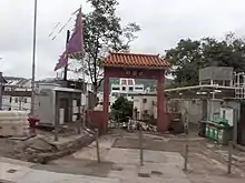
Entrance gate of Pak Wai, viewed from Hiram's Highway.
.png.webp)
Pak Wai on the "Map of the San-On District" by Simeone Volonteri (1866).
Administration
Pak Wai is a recognized village under the New Territories Small House Policy.[1]
History
Pak Wai is a mixed clan village, probably established in the late 17th century. It appears on the "Map of the San-On District", published in 1866 by Simeone Volonteri.[2]
See also
References
- "List of Recognized Villages under the New Territories Small House Policy" (PDF). Lands Department. September 2009.
- Hill, Ronald D. (1985). "Fragments and speculations: the walled villages of Hong Kong". Journal of the Hong Kong Archaeological Society. Hong Kong Archaeological Society. 11: 25-38. OCLC 02465191.
Further reading
- Hamilton, Eric; Schofield, Walter; Peplow, S. H.; Tsui, Paul; Coates, Austin; Hayes, James (2010). "Chapter 6. Sai Kung Peninsula". In Strickland, John (ed.). Southern District Officer Reports: Islands and Villages in Rural Hong Kong, 1910-60. Hong Kong University Press. pp. 237–238. ISBN 9789888028382.
This article is issued from Wikipedia. The text is licensed under Creative Commons - Attribution - Sharealike. Additional terms may apply for the media files.