Pauschikushish Ewiwach River
The Pauschikushish River Ewiwach is a tributary of Dana Lake (Eeyou Istchee Baie-James) in Regional County Municipality (RCM) of Eeyou Istchee Baie-James (municipality), in the administrative region of Nord-du-Québec, in the Canadian province of Quebec, in Canada.
| Pauschikushish Ewiwach | |
|---|---|
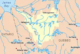
 Watershed of Nottaway River | |
| Location | |
| Country | Canada |
| Province | Quebec |
| Region | Eeyou Istchee Baie-James (municipality) |
| Physical characteristics | |
| Source | Creek of marsh |
| • location | Eeyou Istchee Baie-James (municipality), Nord-du-Québec, Quebec |
| • coordinates | 50°35′16″N 77°20′45″W |
| • elevation | 289 m (948 ft) |
| Mouth | Dana Lake (Eeyou Istchee Baie-James) |
• location | Eeyou Istchee Baie-James (municipality), Nord-du-Québec, Quebec |
• coordinates | 50°44′10″N 77°22′14″W |
• elevation | 241 m (791 ft) |
| Length | 74.8 km (46.5 mi)[1] |
| Basin features | |
| Tributaries | |
| • left | (from the mouth) Matawawskweyasi creek, Matawawaskweyau River, Kakaskutatakuch creek, Iskaskunikaw River. |
| • right | (from the mouth) Mitapeschiskau creek, Kapisaukanew creek. |
The hydrographic slope of the “Pauschikushish Ewiwach River” does not have a nearby access road; however, the northern route from Matagami passes 3.1 kilometres (1.9 mi) west of a curve of the “Pauschikushish Ewiwach River”. The surface of the river is usually frozen from early November to mid-May, however, safe ice circulation is generally from mid-November to mid-April.
Geography
The main hydrographic slopes near the “Pauschikushish Ewiwach River” are:
- North side: Dana Lake (Eeyou Istchee Baie-James), Du Tast Lake;
- East side: Enistustikweyach River, Evans Lake, Broadback River;
- South side: Muskiki River, Nottaway River, Soscumica Lake;
- West side: Dusaux Lake, Nottaway River, Davoust River.
The “Pauschikushish Ewiwach River” has its source of a stream (elevation: 289 metres (948 ft)) surrounded by marsh and located at:
- 3.1 kilometres (1.9 mi) south-west of Lake Ouagama;
- 10.7 kilometres (6.6 mi) south of Evans Lake;
- 20.0 kilometres (12.4 mi) south-east of the mouth of the “Pauschikushish Ewiwach River”;
- 34.2 kilometres (21.3 mi) southeast of the mouth of Dana Lake (Eeyou Istchee Baie-James);
- 99 kilometres (62 mi) north of downtown Matagami.
From its source, the "Pauschikushish Ewiwach River" flows over 74.8 kilometres (46.5 mi) according to the following segments:
Upper course of the' Pauschikushish Ewiwach River (segment of 57.4 kilometres (35.7 mi))
- 13.7 kilometres (8.5 mi) easterly to a creek (coming from the northeast);
- 21.0 kilometres (13.0 mi) westerly passing the north side of a mountain whose summit reaches 322 metres (1,056 ft), to the Iskaskunikaw River (coming from the South);
- 12.3 kilometres (7.6 mi) northwesterly to the northeast of Kakusikuch Hill (elevation: 256 metres (840 ft)) to Kakuskwapiminakuch Creek (coming from the south);
- 10.4 kilometres (6.5 mi) north across the Amikanan Rapids, then forming a hook to the east, to the confluence of the Matawawaskweyau River (coming from the west);
Lower section of the' Pauschikushish Ewiwach River (segment of 17.4 kilometres (10.8 mi))
- 4.7 kilometres (2.9 mi) northeasterly in a marsh zone to Kapisaukanwe Creek (from the southeast);
- 3.1 kilometres (1.9 mi) northeasterly in a marsh zone to Matawawskweyasi Creek (from the northwest);
- 6.1 kilometres (3.8 mi) easterly forming a hook to the south to Mitapeschiskau Creek (coming from the northeast);
- 0.8 kilometres (0.50 mi) north to the mouth of the river.[2]
The "Pauschikushish Ewiwach River" flows into a bay on the south shore of [Dana Lake (Eeyou Istchee Baie-James)] where the current flows north and east, where it flows into a bay west of Evans Lake.
The mouth of the "Pauschikushish Ewiwach River" is located at:
- 25.1 kilometres (15.6 mi) south-west of the mouth of Dana Lake (Eeyou Istchee Baie-James);
- 48.9 kilometres (30.4 mi) Southwest of the mouth of Evans Lake
- 45.2 kilometres (28.1 mi) north of Lake Soscumica;
- 125.2 kilometres (77.8 mi) south-east of the mouth of the Broadback River;
North of downtown Matagami.
Toponymy
Of Cree origin, the toponym "Pauschikushish Ewiwach River" means: "the river flowing from the small rapids".
The toponym "Pauschikushish Ewiwach River" was formalized on December 5, 1968, at the Commission de toponymie du Québec[3]
References
- Atlas of Canada
- Distances from the Atlas of Canada (published on the Internet) of the Department of Natural Resources Canada.
- "Commission de toponymie du Québec (Quebec Geographic Names Board) - Place Names Bank - Toponym: "Pauschikushish River Ewiwach"". toponymie.gouv.qc.ca. Retrieved 2017-11-22.
See also
- James Bay
- Rupert Bay
- Broadback River, a watercourse
- Evans Lake, a body of water
- Dana Lake (Eeyou Istchee Baie-James), a body of water
- Matawawaskweyau River, a watercourse
- Kakaskutatakuch River, a watercourse
- Iskaskunikaw River, a watercourse
- List of rivers of Quebec