Pedja (river)
The Pedja (Estonian: Pedja jõgi) is the fourth longest river in Estonia. Its source is near Simuna on the southern slopes of the Pandivere Upland. The river flows for 122 km through Lääne-Viru, Jõgeva and Tartu counties before joining the Emajõgi northeast of Lake Võrtsjärv. The last 4 km section of the river after confluence with Põltsamaa is known as the Pede. The largest settlement on the river is Jõgeva.
| Pedja | |
|---|---|
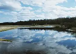
 The Pedja in spring | |
| Location | |
| Country | Estonia |
| Physical characteristics | |
| Source | |
| • location | Simuna, Lääne-Viru County |
| Mouth | Emajõgi |
• coordinates | 58°24′47″N 26°11′28″E |
• elevation | 33 m (108 ft) |
| Length | 122 km (76 mi) |
| Basin size | 2,719 km2 (1,050 sq mi) |
| Discharge | |
| • average | 10.9 m3/s (380 cu ft/s) |
| Basin features | |
| Progression | Emajõgi→ Lake Peipus→ Narva→ Gulf of Finland |
The Pedja is also the origin of the name of Alam-Pedja Nature Reserve, a large protected area on the river's lower reaches.
References
- Pedja jõgi (in Estonian)
This article is issued from Wikipedia. The text is licensed under Creative Commons - Attribution - Sharealike. Additional terms may apply for the media files.