Petersstrasse
Petersstrasse is one of the oldest streets in Leipzig's district of Mitte (neighborhood Zentrum). For centuries it was a main and commercial street for the Leipzig trade fair with exhibition houses, inns and shops. In the second half of the 19th century, many of the old buildings on the street fell victim to the modernization of the city center.[1] Today it is a heavily frequented pedestrian zone in a prime location with shopping centers, department stores, shops, restaurants and cinemas.[2]
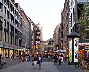 View of Petersstrasse in 2009 | |
| Length | 347 m (1,138 ft) |
|---|---|
| Width | between 11 m (36.1 ft) and 19 m (62.3 ft) |
| Location | Leipzig-Mitte, Leipzig, Germany |
| Postal code | 04109 |
| Nearest metro station | Leipzig Markt station and Leipzig Wilhelm-Leuschner-Platz station of S-Bahn Mitteldeutschland |
| North end | Markt |
| South end | Schillerstrasse |
| Construction | |
| Completion | created before the city was founded in 1165, newly designed 2014 |
Location and history
Petersstraße is 347 m (1,138.5 ft) long and connects Leipzig's market square in a north–south direction with Wilhelm-Leuschner-Platz. At its southern end were until 1860 the Peterstor (gate St. Peter) and until 1886 the eponymous[3] Peterskirche (old church St. Peter). To the south, at the former gate St. Peter, it continues beyond the Inner City Ring Road as Peterssteinweg. It was part of the Via Imperii[4] and the central street of the surrounding Petersviertel (quarter St. Peter).[5]
There were numerous courtyards on Petersstrasse, some of which had passageways into the neighboring streets (on the western side of Petersstrasse to Thomaskirchhof[6] or Burgstrasse, on the eastern side of Petersstrasse to Neumarkt, which was called Neuer Neumarkt until 1839).[7]
Since the middle of the 19th century, the street has been characterized by a large number of trading houses and trade fair exhibition palaces. Petersstrasse was particularly busy during trade fairs in the 19th and 20th centuries.
_b_441.jpg.webp)
The street space experienced a change in scale. Narrow alley structures made the delivery situation for the exhibition palaces too difficult. After the Second World War, Petersstrasse was initially widened in its northern part from 11 m (36.1 ft) to 19 m (62.3 ft).[8]
Today, the entire length of Petersstrasse is designated as a pedestrian zone and is primarily a shopping and business street. With the construction of the house used by Peek and Cloppenburg, the road widening at this point was reversed. In 2019 the Karstadt department store was closed. A new opening as a shopping, office and restaurant building is announced for the end of 2023.[9]
Small crossing streets are Sporergässchen, Preußergässchen, Peterskirchhof and Schlossgasse.
In 2007 and 2008, two tunnel tubes of the Leipzig City Tunnel of the railway were drilled under Petersstrasse.[10] The City Tunnel was opened in 2013 and opens up Petersstraße from the north through the Leipzig Markt station and from the south through the Leipzig Wilhelm-Leuschner-Platz station.
In 2017, the first public drinking fountain was put into operation by the Leipziger Wasserwerke (Leipzig waterworks) in Petersstrasse, which has since been followed by others in Leipzig.[11]
Literature
- Horst Riedel: Stadtlexikon Leipzig von A bis Z. PRO LEIPZIG, Leipzig 2012, ISBN 978-3-936508-82-6, p. 461 f. (in German)
Footnotes
- Sebastian Ringel: Wie Leipzigs Innenstadt verschwunden ist. 150 verlorene Bauten aus 150 Jahren, edition überland, Leipzig 2019, ISBN 978-3-948049-00-3
- City report of the Immobilien-Zeitung undated (in German)
- "Verzeichnis Leipziger Straßennamen mit Erläuterungen" (PDF). Website der Stadt Leipzig (in German). 2018. Retrieved 2023-08-07., including Petersstrasse on p. 2087
- Ringel, Sebastian (2015). Leipzig! One Thousand Years of History. Leipzig: Author and Edition Leipzig in the Seemann Henschel GmbH & Co. KG. p. 11. ISBN 978-3-361-00710-9.
- Friedrich Gottlob Leonhardi, Leipzig um 1800, kommentierte und mit einem Register versehene Neuausgabe der Geschichte und Beschreibung der Kreis- und Handelsstadt Leipzig (1799), hrsg. von Klaus Sohl, Lehmstedt Verlag, Leipzig 2010, ISBN 978-3-942473-03-3, S. 14–18, in German
- Church yard of St. Thomas Church
- Keyword "Petersstraße", on webpage www.leipzig-lexikon.de (in German)
- "Petersstraße, in: Leipzig-Innenstadt. Städtebaulicher Denkmalschutz 1994-2017" (PDF). leipzig.de. Beiträge zur Stadtentwicklung (Blaue Reihe), Issue 61 (in German). Stadt Leipzig, Dezernat Stadtentwicklung und Bau. pp. 52–53. Retrieved 2023-10-01.
- Webpage of the developer (in German)
- "Riesenbohrmaschine Leonie schafft erste Röhre unter Leipzigs City", Leipziger Volkszeitung (in German), p. 1, 2008-03-11
- Erster öffentlicher Trinkwasserbrunnen sprudelt in der Petersstraße, on the webpage of the city of Leipzig, date: 13. July 2017, retrieved 7. August 2023
External links
- "Petersstraße". Leipzig gestern heute (in German). Retrieved 2020-11-13.
- "Petersstraße". Leipzig-Lexikon (in German). Retrieved 2020-11-13.