Petrovo Polje (Croatia)
The Petrovo Polje (Croatian: Petrovo polje, "Peter's Field") is a karstic field in the northern part of Dalmatian Hinterland in Croatia.
| Petrovo field | |
|---|---|
| Petrovo polje | |
| Floor elevation | 260 to 330 m (850 to 1,080 ft)[1] |
| Length | 17 km (11 mi) NW-SE[2] |
| Width | 7 km (4.3 mi) |
| Area | 57 km2 (22 sq mi) |
| Geology | |
| Type | Polje |
| Geography | |
| Country | Croatia |
| State/Province | Zagora |
| District | Šibenik-Knin County |
| Borders on | |
| Coordinates | 43.856806°N 16.210145°E |
| River | Čikola |
Geography
Petrovo Polje is the shape of an isosceles triangle 17 kilometres (11 mi) long and 7 kilometres (4.3 mi) wide, and is surrounded by mountains Svilaja, Promina and Moseć. It slopes from the north-east at 320 m.a.s.l. to its south-western end at 265 m.a.s.l. Its area is 57 km2 (22 sq mi).[2][3]
Climate
The climate of Petrovo Polje has the elements of both the cooler and harsher continental climate of the north and the warmer climate predominant in the south. In the winter, jugo and bora winds are common. The average number of frost days per year is 30, between October and April. Summers are dry.[4]
Settlements
The settlements are situated on the edge of the field: Drniš, Kričke, Ružić, Umljanović, Kljake, Čavoglave, Gradac, Otavice, Kanjane, Parčić, Miočić, Biočić, Tepljuh, Siverić, Badanj. Kadina Glavica is located on the hill with the same name, while Baljci and Mirlović Polje are located above the field, on the slopes of Svilaja.
History and culture

In the antiquity, Petrovo Polje was known under the name of Campus Illyricum. Its present-day name, first mentioned in the 11th century, is believed to refer to Petar Snačić (or Svačić), the last Croatian king, and his Petrovac castle which he built in the Petrovo Polje's northern edge.[2][3]
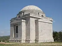
In Otavice, a small village on the edge of Petrovo Polje, there is a Church of the Most Holy Redeemer, which is also the Meštrović family mausoleum, built by the famous Croatian sculptor Ivan Meštrović between 1926 and 1930.[5]
See also
References
- Ostroški, Ljiljana, ed. (December 2015). Statistički ljetopis Republike Hrvatske 2015 [Statistical Yearbook of the Republic of Croatia 2015] (PDF). Statistical Yearbook of the Republic of Croatia (in Croatian and English). Vol. 47. Zagreb: Croatian Bureau of Statistics. p. 51. ISSN 1333-3305. Retrieved 27 December 2015.
- Aralica 2008, p. 318.
- "How it all began: fields". np-krka.hr. Krka National Park. Retrieved 20 June 2020.
- Aralica 2008, pp. 318–319.
- "Otavice". Croatian Encyclopedia (in Croatian). Miroslav Krleža Institute of Lexicography. Retrieved 20 June 2020.
Bibliography
- Aralica, Mile (2008). "Petropoljska raskršća" [The crossroads of Petropolje] (PDF). Titius (in Croatian). 1 (1): 317–328. Retrieved 20 June 2020.
