Petza'el
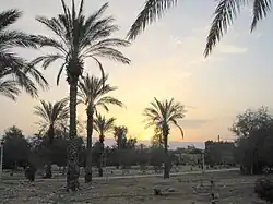
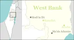
Petza'el (Hebrew: פְּצָאֵל) is a moshav and Israeli settlement in the West Bank. Located in the center of the Jordan Valley, 34.5 kilometers from the Green line, it falls under the jurisdiction of Bik'at HaYarden Regional Council.[2] In 2021 it had a population of 361. It is named for Phasael, older brother of Herod the Great, for whom he had named a city nearby in ancient times.
Petza'el
פְּצָאֵל | |
|---|---|
 | |
 Petza'el | |
| Coordinates: 32°02′39″N 35°26′32″E | |
| District | Judea and Samaria Area |
| Council | Bik'at HaYarden |
| Region | West Bank |
| Affiliation | Moshavim Movement |
| Founded | 1970 |
| Founded by | Moshavim Movement |
| Population (2021)[1] | 361 |
The international community considers Israeli settlements in the West Bank illegal under international law, but the Israeli and US governments dispute this.[3]
History
Antiquity
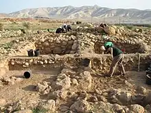
Under the Roman Empire, area was known as Phasaelis. (Greek: Φασαηλίς, Phasaēlís, or Φασηλίς, Phasēlís). The ancient name derived from a tower that Herod the Great, the king of Judea (Roman province), built in the Jordan Valley north of Jericho in dedication to his elder brother Phasael.[4] Hence the theory that Herod founded Phasaelis.[5][6] The town is described by Jewish historian and commander in the First Jewish-Roman War Josephus as being south of Archelais. It was part of a toparchy ruled by Herod's sister Salome I.[7]
Modern era
Petza'el was established near Ma'ale Efraim in 1970 by former soldiers who were members of the Moshavim Movement. The settlement was initially administered as both a moshav and a kibbutz. In 1975 the settlement moved to a location in the valley where the agricultural fields of the members were located. According to ARIJ, in order to construct Petza'el Israel confiscated land from two Palestinian villages: 1,242 dunams from Fasayil,[8] 176 dunams from Al-Jiftlik[9]
In recent years, the settlements has absorbed around 30 new families, mostly the children of the founding members.[2][10]
Economy
Most of the settlement's residents earn their living from agriculture. The younger members work in both agriculture and other jobs.[2]

In the 2013 the settlement had 3,960 dunams of cultivated land, of which 2,700 dunams was used for date palms, 800 for vineyards, 400 for vegetables (mostly peppers) and 60 for flowers.[2] Most of the agricultural output is designated for export.[11] There are conflicting views about the builder of a race track near the settlement. Haaretz reported the illegal race track was built by the west bank regional council by using public funds.[12]
Community and civic services
The settlement operates two kindergartens, several clubs for the members, a synagogue, pool, grocery store and recreation sites. Some of the electricity is created by solar panels in the settlements and some residents also use solar panels for their personal use.[2]
References
- "Regional Statistics". Israel Central Bureau of Statistics. Retrieved 22 February 2023.
- "פצאל [Petza'el]". Bik'at HaYarden regional council website.
- "The Geneva Convention". BBC News. 10 December 2009. Retrieved 27 November 2010.
- Josephus, Jewish War 1.21.9;
- The Estate of the Southern Jordan River Archived 2013-04-16 at archive.today Virtual Karak Resources Project and Appalachian College Association.
- Conder and Kitchener, 1883, SWP III, p. 388
- The Toparchy of Salome, Sister of King Herod, and its Towns: Archelais, Phasaelis, and Livias
- Fasayil Village Profile p. 17, ARIJ
- Al Jiftlik Village Profile p. 17, ARIJ
- Hareuveni, Immanuel; Eretz Yisrael Lexicon; Ministry of Education p.796
- "פצאל [Petza'el]". Jordan Valley Tourism.
- "West Bank regional council built illegal racetrack with public Israeli funds". Haaretz.