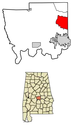
Pine Level, Autauga County, Alabama
Pine Level is a census-designated place and unincorporated community in Autauga County, Alabama, north of Prattville and west of Deatsville. As of the 2010 census, its population was 4,183.[3] Pine Level is home to Pine Level Elementary School and Marbury High School, part of the Autauga County School System.
Pine Level, Alabama | |
|---|---|
 | |
 Pine Level, Alabama | |
| Coordinates: 32°35′01″N 86°27′56″W | |
| Country | United States |
| State | Alabama |
| County | Autauga |
| Area | |
| • Total | 25.22 sq mi (65.33 km2) |
| • Land | 25.17 sq mi (65.20 km2) |
| • Water | 0.05 sq mi (0.13 km2) |
| Elevation | 574 ft (175 m) |
| Population (2020) | |
| • Total | 4,885 |
| • Density | 194.05/sq mi (74.92/km2) |
| Time zone | UTC-6 (Central (CST)) |
| • Summer (DST) | UTC-5 (CDT) |
| ZIP code | 36067,36066,36022 |
| Area code | 334 |
| GNIS feature ID | 124826[2] |
The community is located along U.S. Route 31, 18 mi (29 km) northwest of Montgomery and 77 mi (124 km) south of Birmingham, both via I-65.
References
- "2020 U.S. Gazetteer Files". United States Census Bureau. Retrieved October 29, 2021.
- "Pine Level". Geographic Names Information System. United States Geological Survey, United States Department of the Interior.
- "U.S. Census website". United States Census Bureau. Retrieved May 14, 2011.
- "Census of Population and Housing". Census.gov. Retrieved June 4, 2016.
Municipalities and communities of Autauga County, Alabama, United States | ||
|---|---|---|
| Cities | 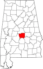 Map of Alabama highlighting Autauga County | |
| Towns | ||
| CDPs | ||
| Unincorporated communities | ||
| Ghost town | ||
| Footnotes | ‡This populated place also has portions in an adjacent county or counties | |
This article is issued from Wikipedia. The text is licensed under Creative Commons - Attribution - Sharealike. Additional terms may apply for the media files.