Piz Julier
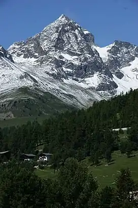
Piz Julier (German, Romansh: Piz Güglia) is a mountain of the Albula Alps, overlooking the Julier Pass, in the Swiss canton of Graubünden. With a height of 3,380 metres above sea level, Piz Julier is the second highest peak (after Piz Calderas) of the group between the Julier Pass and the Albula Pass.
| Piz Julier | |
|---|---|
| Piz Güglia | |
 View from St. Moritz (east side) | |
| Highest point | |
| Elevation | 3,380 m (11,090 ft) |
| Prominence | 489 m (1,604 ft)[1] |
| Parent peak | Piz Calderas |
| Isolation | 7.0 km (4.3 mi)[2] |
| Listing | Alpine mountains above 3000 m |
| Coordinates | 46°29′27.3″N 9°45′35.8″E |
| Geography | |
 Piz Julier Location in Switzerland | |
| Location | Graubünden, Switzerland |
| Parent range | Albula Alps |
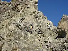
Piz Julier can be summited by experienced hikers. From the heights of St. Moritz, a trail leads to Fuorcla Albana (2,870 metres), the pass between Piz Julier and Piz Albana. From there a via ferrata, named Senda Enferrada leads to the summit.

Climbers on the normal route
References
- Retrieved from the Swisstopo topographic maps. The key col is the Fuorcla Güglia (2,891 m).
- Retrieved from Google Earth. The nearest point of higher elevation is southeast of Piz Calderas.
External links
 Media related to Piz Julier at Wikimedia Commons
- Piz Julier on Hikr
- Piz Julier on Summitpost
This article is issued from Wikipedia. The text is licensed under Creative Commons - Attribution - Sharealike. Additional terms may apply for the media files.