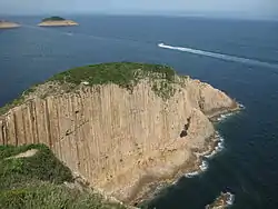
Po Pin Chau
Po Pin Chau (Chinese: 破邊洲) is an island in Hong Kong. Off the eastern coast of the East Dam of the High Island Reservoir, the island is known for its hexagonal columnar jointing po po pooiong. The island was originally a cape connected to the mainland, but eventually broke away from the mainland due to years of erosion. The island is administered by the Sai Kung District.[1][2][3]

.jpg.webp)
Geology
The columnar rock formations on the island were formed after a series of volcanic eruptions in Hong Kong during the Jurassic Era.[4]
Conservation
Po Pin Chau is part of the Hong Kong Geopark and Sai Kung East Country Park.
Po Pin Chau is part of the High Island Special Area (糧船灣特別地區), which covers 3.9 hectares and was designated in 2011.[5] The area includes the two islands Po Pin Chau and Conic Island and no part of High Island proper.[6] The geology of the area is characterised by volcanic rocks of the Cretaceous period.[7]
References
- "破邊洲". trippers.info.
- 亞洲電視:《香港風華》,青桐社 ISBN 962-451954-4
- "山上行‧破邊洲". walkonhill.com. 8 May 2015.
- Williams, Martin (12 October 2015). "The four best sights in Hong Kong's below-the-radar geopark and how to visit them". South China Morning Post. Retrieved 28 August 2022.
- "Country Parks & Special Areas". Agriculture, Fisheries and Conservation Department.
- "Double Haven and Others (Special Areas) Order 2010" (PDF). Legislative Council of Hong Kong. 20 October 2010.
- "Five geologically important sites designated as special areas". Government of Hong Kong. 31 December 2010.