Ponta Creek
Ponta Creek is a stream in the U.S. states of Alabama and Mississippi.[2] It is a tributary to the Sucarnoochee River. Tributaries include Lost Horse Creek, Possum Creek, and Big Creek.[3][4]
| Ponta Creek | |
|---|---|
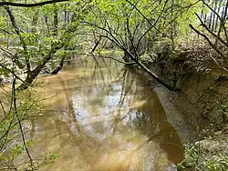
 Ponta Creek after a rain. | |
| Location | |
| Country | United States |
| State | Alabama and Mississippi |
| Physical characteristics | |
| Source | |
| • coordinates | 32.575338°N 88.695623°W |
| Mouth | |
• coordinates | 32.611829°N 88.364464°W |
| Length | 23.5 mi (37.8 km) |
| Basin size | 64.6 sq mi (167 km2)[1] |
Ponta is a name derived from the Choctaw language purported to mean "mouse".[5] Variant names are "Panthe Creek" and "Ponti Creek".[2]
The Choctaw settlement of Coosha was located on Ponta Creek.[3] One of the three main divisions of the Choctaw tribe, the Eastern Division, lived in the area around Ponta Creek.[6] In 1795, 99 Choctaw lived in the village of Pante on Ponta Creek, with Hochinchimastabe serving as the village captain.[7]
References
- Telis, Pamela (1991). Low-flow and Flow-duration Characteristics of Mississippi Streams. Washington, D.C.: U.S. Geological Survey. p. 134.
- U.S. Geological Survey Geographic Names Information System: Ponta Creek
- Riley, Franklin L., ed. (1902). Publications of the Mississippi Historical Society, Volume VI. Oxford, Mississippi: Mississippi Historical Society. p. 416.
- Logan, William N. (1914). The Pottery Clays of Mississippi. Jackson, Mississippi: Mississippi State Geological Survey. p. 200.
- Baca, Keith A. (2007). Native American Place Names in Mississippi. University Press of Mississippi. p. 84. ISBN 978-1-60473-483-6.
- Barnett, James F., Jr. (2012). Mississippi's American Indians. Jackson, Mississippi: University Press of Mississippi. p. 92. ISBN 978-1-61703-245-5.
{{cite book}}: CS1 maint: multiple names: authors list (link) - "1795 Census of the Choctaws". Choctaw Nation ITGenWeb. Retrieved August 1, 2023.
This article is issued from Wikipedia. The text is licensed under Creative Commons - Attribution - Sharealike. Additional terms may apply for the media files.