Pooles Island
Pooles Island is a small island located on the Chesapeake Bay, part of Harford County, Maryland.[1] It is southeast of the southern tip of Gunpowder Neck. The Pooles Island Light was built on it. Pooles Island was used for bombing practice from 1918 through the 1960s as part of Aberdeen Proving Ground. Access to the island is prohibited due to unexploded ordnance.[2]
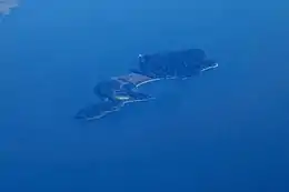 Pooles Island in 2020 | |
| Geography | |
|---|---|
| Location | Chesapeake Bay |
| Coordinates | 39°17′07″N 76°15′57″W |
| Length | 1.5 km (0.93 mi) |
| Administration | |
United States | |
| State | Maryland |
| Demographics | |
| Population | 0 (2020) |
Poole's Island was first occupied by Native Americans. The shell middens on the island were evidence of their presence. It was first sighted by Europeans in 1608 wshen Captain John Smith explored the Chesapeake. He named it after Nathanial Powell, a member of his party. Over the years the name evolved from "Powell's Island" to "Poole's Island".
In 1855, two watermen Capt. Elijah Williams and Capt. James Williams, were lost in a storm. Capt. Elijah William's body washed ashore on the island, while his older brother James' body was never found; Elijah was buried by the lighthouse keeper.
References
- USGS Gunpowder Neck, MD 7.5" Quadrangle Map, 2019. 1:24:000 scale.
- "Chesapeake History: Pooles Island | PropTalk".