Port Louis District
Port Louis (French: Port-Louis) is a district of Mauritius, located in the northwest of the island, it is the smallest district and has the highest population density. The district wholly encompasses Port Louis, the capital of the country. Port Louis district has an area of 42.7 km2 and the population estimate was at 118,123 as at the end of 2019.[2]
Port Louis
Port-Louis | |
|---|---|
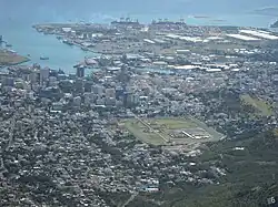 Port Louis and its harbour | |
 Flag | |
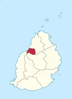 Map of Mauritius island with Port Louis District highlighted | |
| Coordinates: 20°10′S 57°31′E | |
| Country | |
| Government | |
| • Type | City Council |
| • Lord Mayor | Mr. Hoseenally Aslam Adam |
| • Deputy Lord Mayor | Mrs. Chukowry M. Christianne Dorinne |
| Area | |
| • Total | 42.7 km2 (16.5 sq mi) |
| Population (2019)[2] | |
| • Total | 118,123 |
| • Rank | 4th in Mauritius |
| • Density | 2,800/km2 (7,200/sq mi) |
| Time zone | UTC+4 (MUT) |
| ISO 3166 code | MU-PL (Port Louis) |
| Website | www |
Places of interest
The district hosts the Aapravasi Ghat, a UNESCO World Heritage Site since 2006.
References
- "Portal of Local Authorities, Mauritius". Retrieved 8 March 2014.
- "Table 1.6(b) - Estimated resident population1 by geographical district, sex and density - Republic of Mauritius2, 2018 & 2019". Annual Digest of Statistics 2019 (XLS). Statistics Mauritius. November 2020.
| Subdivisions |
| .svg.png.webp) | ||||||||||||
|---|---|---|---|---|---|---|---|---|---|---|---|---|---|---|
| Politics | ||||||||||||||
| Economy | ||||||||||||||
| Society |
| |||||||||||||
This article is issued from Wikipedia. The text is licensed under Creative Commons - Attribution - Sharealike. Additional terms may apply for the media files.