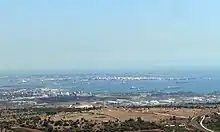
Port of Augusta
Port of Augusta (Italian: Porto di Augusta) is a port serving Augusta, Sicily. In 2007, 33.041 million tonnes passed through the port.

History
The natural port has been used since ancient times. In the 1910s the Royal Italian Navy developed the port and established an important military base to exercise control of the coast. The port was used by the Regia Marina during the Italo-Turkish War (1911-1912) and during the landing in Sicily by the Allies the port was subjected to repeated raids.
_1943.jpg.webp)
An air base was built in Augusta harbor between November 1917 and 1920 with a reinforced concrete airship hangar for use as a bombing and gunnery training school and as a reconnaissance base. Converted into a seaplane station in 1925, it became Italy’s main seaplane base on Sicily. During the war years, some 30 seaplanes were usually here at any one time including the types CANT Z.501 Gabbiano, CANT Z.506 Airone, Fiat RS.14 and the IMAM Ro.43. The base was protected by the Augusta harbor and town defenses which in late 1942 consisted of at least 8 to 13 anti-aircraft gun positions with 45-65 heavy anti-aircraft guns and 8 light anti-aircraft guns.
During the Battle of Sicily the port was subjected to repeated raids. It was occupied by the British Navy from 1943 to 1946. Oil tycoon Angelo Moratti's oil refinery Rasiom Moratti was built in 1949,[1][2] marking the beginning of its history as a large-scale industrial harbor, nowadays part of the petrochemical complex Augusta-Priolo. It underwent significant development in the 1950s and early 1960s with the establishment of Sincat, belonging to the Edison Group, which operated in the sectors of inorganic chemicals and fertilizers, the power plant Tifeo, and numerous other firms including Liquigas, Ilgas, Sotis Cables and Siciltubi.
References
- "Augusta, un premio a Moratti "Capitano d'industria" (in Italian). Srlive.it. 2015-01-05. Retrieved 6 May 2015.
- "La Sicilia dei veleni, dalla raffineria nel siracusano al petrolchimico di Gela". Il Fatto Quotidiano. August 2012.