Portal:Australian roads/Selected article/1
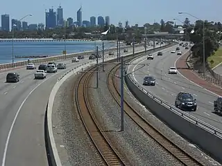
The Kwinana Freeway is a 72-kilometre (45 mi) freeway in and beyond the southern suburbs of Perth, Western Australia, linking central Perth with Mandurah to the south. It is the central section of State Route 2, which continues north as Mitchell Freeway to Clarkson, and south as Forrest Highway towards Bunbury. A 4-kilometre (2.5 mi) section between Canning and Leach highways is also part of National Route 1. Along its route are interchanges with several major roads, including Roe Highway and Mandjoogoordap Drive. The northern terminus of the Kwinana Freeway is at the Narrows Bridge, which crosses the Swan River, and the southern terminus is at Pinjarra Road, east of Mandurah.

Planning for the Kwinana Freeway began in the 1950s, and the first segment in South Perth was constructed between 1956 and 1959. The route has been progressively widened and extended south since then. During the 1980s, the freeway was extended to South Street in Murdoch, and in June 2001, it reached Safety Bay Road in Baldivis. The final extension began as the New Perth Bunbury Highway project, constructed between December 2006 and September 2009. In early 2009, the section north of Pinjarra Road was named as part of the Kwinana Freeway, with the remainder named Forrest Highway. The freeway has been adapted to cater for public transport, with the introduction of bus priority measures in 1987, and the 2007 opening of the Mandurah railway line, constructed in the freeway median strip. (Full article...)