French Prealps
The French Prealps (French: Préalpes françaises, pronounced [pʁealp fʁɑ̃sɛz]) are a group of subalpine mountain ranges of medium elevation located immediately west of the French Alps. They roughly stretch from Lake Geneva southwest to the rivers Isère and Drôme; east to a line running from Chamonix, to Albertville, to Grenoble, to Gap, to Barcelonette; and south from Grasse to Vence.
| French Prealps | |
|---|---|
| Prealps — Préalpes (French) | |
 Summits in the Chartreuse Mountains, part of the French Prealps | |
| Highest point | |
| Peak | Haute Cime |
| Elevation | 10,686 ft (3,257 m) |
| Geography | |
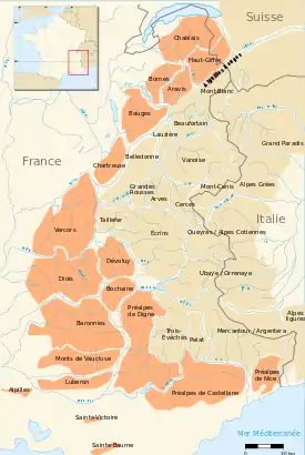
 Ranges of the French Alps,
with the Prealps ranges highlighted in orange | |
| Country | France |
| Regions | Rhône-Alpes and Provence-Alpes-Côte d'Azur |
| Range coordinates | 43°59′N 6°6.65′E |
| Parent range | Alps |
| Geology | |
| Orogeny | Alpine orogeny |
| Age of rock | Mesozoic and Tertiary |
| Type of rock | Sedimentary and Flysch |
In the northern subalpine regions, the various ranges are easily identifiable by geographical separations, such as the Voreppe Gorge between Vercors and Chartreuse, or Chambéry, which sits in a valley between the Bauges and Chartreuse ranges. In the southern subalpine regions, the ranges are generally disorganized and lack the wide, deep valleys that divide them in the north.
Three non-contiguous ranges traditionally comprise the southern French Prealps: the Alpilles, Mont Sainte-Victoire and Sainte-Baume.
Ranges and peaks
| Chain | Range | Highest summit | Elevation (m/ft) | Comments |
|---|---|---|---|---|
| Savoy Prealps | Haut-Giffre Massif | Dents du Midi, Haute Cime | 3,257 metres (10,686 ft) | Highest summit in the French Prealps |
| Savoy Prealps | Aiguilles Rouges | Aiguille du Belvédère | 2,965 metres (9,728 ft) | |
| Savoy Prealps | Chablais Alps | Hauts-Forts | 2,464 metres (8,084 ft) | Peak on French side of the range |
| Savoy Prealps | Bornes | Pointe Blanche | 2,438 metres (7,999 ft) | |
| Savoy Prealps | Aravis Range | Pointe Percée | 2,750 metres (9,022 ft) | |
| Savoy Prealps | Bauges | Arcalod | 2,217 metres (7,274 ft) | |
| Savoy Prealps | Chartreuse Mountains | Chamechaude | 2,082 metres (6,831 ft) | |
| Dauphiné Prealps | Vercors Plateau | Grand Veymont | 2,341 metres (7,680 ft) | also called the French Dolomites |
| Dauphiné Prealps | Diois Mountains | Mont Jocou | 2,051 metres (6,729 ft) | |
| Provence Prealps | Baronnies | Mont Mare | 1,603 metres (5,259 ft) | |
| Dauphiné Prealps | Dévoluy Mountains | Grande Tête de l'Obiou | 2,789 metres (9,150 ft) | |
| Dauphiné Prealps | Bochaine | Mont Céüse | 2,016 metres (6,614 ft) | also called the Pays du Buëch |
| Provence Prealps | Massif des Trois-Évêchés | Tête de l'Estrop | 2,961 metres (9,715 ft) | |
| Provence Prealps | Digne Prealps | Les Monges | 2,115 metres (6,939 ft) | |
| Provence Prealps | Vaucluse Mountains | Signal de Saint-Pierre | 1,256 metres (4,121 ft) | |
| Provence Prealps | Luberon Mountains | Mourre Nègre | 1,125 metres (3,691 ft) | |
| Provence Prealps | Castellan Prealps | Puy de Rent | 1,996 metres (6,549 ft) | also called the Grasse Prealps |
| Maritime Prealps | Nice Prealps | Pointe des Trois Communes | 2,080 metres (6,824 ft) | Highest point on the Authion Massif |
| Non-contiguous | Alpilles | Tour des Opies | 498 metres (1,634 ft) | Traditional southern range |
| Non-contiguous | Mont Sainte-Victoire | Pic des Mouches | 1,011 metres (3,317 ft) | Traditional southern range |
| Non-contiguous | Sainte-Baume | Joug de l'Aigle | 1,148 metres (3,766 ft) | Traditional southern range |
Among the best known peaks in the French Prealps are:
- Mont Ventoux, near Carpentras, Vaucluse, called the "Giant of Provence" 1,912 metres (6,273 ft)
- Mont Aiguille, near Chichilianne, Isère, which has a distinctive broad flat top, 2,087 metres (6,847 ft)
References
- L'Organisation structurale des Alpes françaises (French)
- Raoul Blanchard (1938–1956), Les Alpes Occidentales. Paris: Édition Arthaud. (French)
- Roger Frison-Roche (1964), Les montagnes de la terre. Paris: Flammarion. (French)