Praslin Quarter
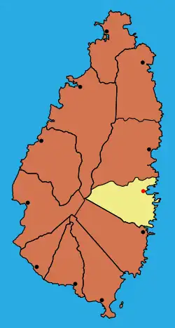
Praslin Quarter was a former quarter on the island nation of Saint Lucia. Since at least 2001, it has been a second-order subdivision of the Micoud District.[2] The 2001 and 2010 Census show Praslin as part of the Micoud District. The population of Praslin is 341.[1][3][4]
Praslin | |
|---|---|
 Former Praslin Quarter in Saint Lucia | |
 Praslin Location of Praslin in Micoud District, Saint Lucia | |
| Coordinates: 13.87545°N 60.89717°W | |
| Country | Saint Lucia |
| District | Micoud District |
| 2nd-order administrative division | Praslin |
| Population (2010)[1] | |
| • Total | 341 |
| Praslin 2nd-order subdivision | |
Places of interest
Other places of interest in the Praslin region are:[1]
- Old Settlement (13°53′00″N 60°54′00″W)
- Praslin Bay (13°52′25″N 60°53′18″W)
- Praslin Island (13°52′31″N 60°53′23″W)
- Praslin Estate (13°53′01″N 60°53′47″W).
- Rivière des Trois Islets stream, (13°52′44″N 60°53′45″W)
History
An English explorer, Thomas Warner, sent Capt. Judlee with 300-400 Englishmen to establish a settlement at Praslin Bay but they were attacked over three weeks by Caribs, until the few remaining colonists fled on 12 October 1640.[5]
References
- "Praslin". GeoNames. Retrieved August 14, 2021.
- Law, Gwillim (2015). "Districts of Saint Lucia". Statoids. Retrieved August 10, 2021.
- "Map of Micoud District showing Praslin division" (PDF). Government of Saint Lucia. Retrieved August 14, 2021.
- "2001 Census" (PDF). Government of Saint Lucia. Retrieved August 11, 2021.
- Harmsen, Jolien; Ellis, Guy; Devaux, Robert (2014). A History of St Lucia. Vieux Fort: Lighthouse Road. p. 10. ISBN 9789769534001.
This article is issued from Wikipedia. The text is licensed under Creative Commons - Attribution - Sharealike. Additional terms may apply for the media files.