County of St. Paul No. 19
The County of St. Paul No. 19 is a municipal district in eastern central Alberta, Canada. Located in Census Division No. 12, its municipal office is located in the Town of St. Paul.[3]
County of St. Paul No. 19 | |
|---|---|
 Welcome sign | |
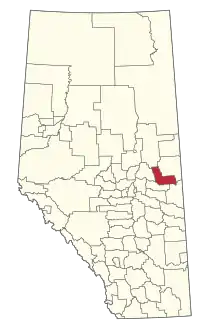 Location within Alberta | |
| Country | Canada |
| Province | Alberta |
| Region | Northern Alberta |
| Census division | 12 |
| Established | 1942 |
| Incorporated | 1962 (County) |
| Government | |
| • Reeve | Glen Ockerman |
| • Governing body | County of St. Paul Council |
| • Administrative office | St. Paul |
| Area (2021)[2] | |
| • Land | 3,280.4 km2 (1,266.6 sq mi) |
| Population (2021)[2] | |
| • Total | 6,306 |
| • Density | 1.9/km2 (5/sq mi) |
| Time zone | UTC−7 (MST) |
| • Summer (DST) | UTC−6 (MDT) |
| Website | county.stpaul.ab.ca |
History
It was previously known as the Municipal District of St. Paul No. 86 until January 1, 1962 when it became the County of St. Paul No. 19.
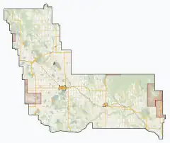
Geography
Communities and localities
|
The following urban municipalities are surrounded by the County of St. Paul No. 19.[4]
|
The following hamlets are located within the County of St. Paul No. 19.[4]
|
The following localities are located within the County of St. Paul No. 19.[5]
- Localities
|
|
Demographics
In the 2021 Census of Population conducted by Statistics Canada, the County of St. Paul No. 19 had a population of 6,306 living in 2,491 of its 3,764 total private dwellings, a change of 4.5% from its 2016 population of 6,036. With a land area of 3,280.4 km2 (1,266.6 sq mi), it had a population density of 1.9/km2 (5.0/sq mi) in 2021.[2]
The population of the County of St. Paul No. 19 according to its 2017 municipal census is 6,468,[7] a change of 4.9% from its 2012 municipal census population of 6,168.[8]
In the 2016 Census of Population conducted by Statistics Canada, the County of St. Paul No. 19 had a population of 6,036 living in 2,334 of its 3,562 total private dwellings, a 3.6% change from its 2011 population of 5,826. With a land area of 3,309.44 km2 (1,277.78 sq mi), it had a population density of 1.8/km2 (4.7/sq mi) in 2016.[9]
References
- Alberta Municipal Affairs: Municipal Officials Search
- "Population and dwelling counts: Canada, provinces and territories, and census subdivisions (municipalities)". Statistics Canada. February 9, 2022. Retrieved February 9, 2022.
- "County of St. Paul No. 19 - Location and History Profile". Alberta Municipal Affairs. May 13, 2011. Retrieved May 17, 2011.
- "Specialized and Rural Municipalities and Their Communities" (PDF). Alberta Municipal Affairs. January 12, 2022. Retrieved January 21, 2022.
- "Standard Geographical Classification (SGC) 2006, Economic Regions: 4812014 - St. Paul County No. 19, geographical codes and localities, 2006". Statistics Canada. March 5, 2010. Archived from the original on May 25, 2013. Retrieved August 12, 2012.
- Geo-Administrative Areas (Hamlet, Locality and Townsite Culture Points) (Geodatabase layer) (Map). AltaLIS. October 26, 2020. Retrieved October 2, 2021.
{{cite map}}: CS1 maint: date and year (link) - 2017 Municipal Affairs Population List (PDF). Alberta Municipal Affairs. ISBN 978-1-4601-3652-2. Retrieved January 13, 2018.
- 2016 Municipal Affairs Population List (PDF). Alberta Municipal Affairs. ISBN 978-1-4601-3127-5. Retrieved January 13, 2018.
- "Population and dwelling counts, for Canada, provinces and territories, and census subdivisions (municipalities), 2016 and 2011 censuses – 100% data (Alberta)". Statistics Canada. February 8, 2017. Retrieved February 8, 2017.
External links
Places adjacent to County of St. Paul No. 19 | |
|---|---|