Promontory Point (Utah)
Promontory Point is the cape or southernmost point of the peninsula formed where the Promontory Mountains project into the northern Great Salt Lake in southeastern Box Elder County, Utah, United States.[1][2]
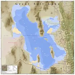
Promontory Peninsula with the Lucin Cutoff crossing the end of the peninsula
Promontory Point | |
|---|---|
 Promontory Point Location within the state of Utah  Promontory Point Location within the United States | |
| Coordinates: 41°13′20″N 112°24′41″W | |
| Location | Box Elder County, Utah United States |
| Range | Promontory Mountains |
| Offshore water bodies | Great Salt Lake |
| Elevation | 1,497 m (4,912 ft) |
Description
The cape is 3 miles (4.8 km) northwest of the west end of Fremont Island in Weber County.[2] The Lucin Cutoff passes 1,250 feet (380 m) north of the point of the cape.[2]
The unincorporated community of Promontory and its location, Promontory Summit, are also frequently referred to as "Promontory Point".[3] Promontory Summit is the site where the First transcontinental railroad was completed and is located about 30 miles (48 km) north–northwest of the cape, near the north end of the Promontory Mountains.
See also
References
- U.S. Geological Survey Geographic Names Information System: Promontory Point
- Promontory Point, Utah, 7.5 Minute Quadrangle, USGS, 1991
- "Ceremony at "Wedding of the Rails," May 10, 1869 at Promontory Summit, Utah Territory". World Digital Library. 1869-05-10. Retrieved 2013-07-20.
This article is issued from Wikipedia. The text is licensed under Creative Commons - Attribution - Sharealike. Additional terms may apply for the media files.