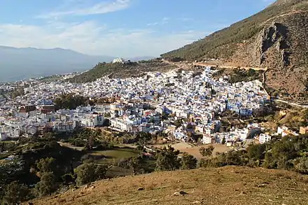
Chefchaouen Province
Chefchaouen is a province in the Moroccan economic region of Tanger-Tetouan-Al Hoceima. According to the 2014 national census in Morocco, the province has more than 457,432 inhabitants. The population is 87.45% rural.[1]

Chefchaouen-hill
The major cities and towns are:[2]
Subdivisions
The province is divided administratively into the following:[3]
| Name | Geographic code | Type | Households | Population (2004) | Foreign population | Moroccan population | Notes |
|---|---|---|---|---|---|---|---|
| Chefchaouen | 151.01.01. | Municipality | 7739 | 35709 | 58 | 35651 | |
| Amtar | 151.03.01. | Rural commune | 1459 | 10038 | 0 | 10038 | |
| Bab Berred | 151.03.03. | Rural commune | 3879 | 23239 | 0 | 23239 | 5043 residents live in the center, called Bab Berred; 18196 residents live in rural areas. |
| Bni Ahmed Cherqia | 151.03.05. | Rural commune | 2021 | 10365 | 1 | 10364 | |
| Bni Ahmed Gharbia | 151.03.07. | Rural commune | 2286 | 12923 | 1 | 12922 | |
| Bni Rzine | 151.03.09. | Rural commune | 2630 | 19585 | 0 | 19585 | |
| Bni Smih | 151.03.11. | Rural commune | 2109 | 15577 | 0 | 15577 | |
| Iounane | 151.03.13. | Rural commune | 3085 | 23132 | 0 | 23132 | |
| Mansoura | 151.03.15. | Rural commune | 2664 | 16559 | 0 | 16559 | |
| M'Tioua | 151.03.17. | Rural commune | 1867 | 12076 | 0 | 12076 | 2984 residents live in the center, called Jebha; 9092 residents live in rural areas. |
| Ouaouzgane | 151.03.19. | Rural commune | 2279 | 16075 | 0 | 16075 | |
| Oued Malha | 151.03.21. | Rural commune | 1974 | 12088 | 0 | 12088 | |
| Tamorot | 151.03.23. | Rural commune | 3581 | 24541 | 0 | 24541 | |
| Bab Taza | 151.05.01. | Rural commune | 4544 | 28549 | 0 | 28549 | 4006 residents live in the center, called Bab Taza; 24543 residents live in rural areas. |
| Bni Darkoul | 151.05.03. | Rural commune | 1888 | 11706 | 0 | 11706 | |
| Bni Faghloum | 151.05.05. | Rural commune | 1603 | 9951 | 0 | 9951 | |
| Bni Salah | 151.05.07. | Rural commune | 1384 | 9662 | 0 | 9662 | |
| Derdara | 151.05.09. | Rural commune | 1644 | 10762 | 0 | 10762 | |
| Fifi | 151.05.11. | Rural commune | 1312 | 7720 | 0 | 7720 | |
| Laghdir | 151.05.13. | Rural commune | 1278 | 7077 | 0 | 7077 | |
| Tanaqoub | 151.05.15. | Rural commune | 1157 | 7219 | 0 | 7219 | |
| Bni Bouzra | 151.07.01. | Rural commune | 2245 | 15254 | 0 | 15254 | |
| Bni Mansour | 151.07.03. | Rural commune | 2468 | 18542 | 0 | 18542 | |
| Bni Selmane | 151.07.05. | Rural commune | 3090 | 23396 | 0 | 23396 | |
| Steha | 151.07.07. | Rural commune | 1695 | 10637 | 0 | 10637 | |
| Talambote | 151.07.09. | Rural commune | 1465 | 10659 | 0 | 10659 | |
| Tassift | 151.07.11. | Rural commune | 1193 | 8139 | 0 | 8139 | |
| Tizgane | 151.07.13. | Rural commune | 1883 | 11711 | 1 | 11710 | |
References
- "Recensement Général de la Population et de l'Habitat de 2014 : Population Légale du Maroc". Haut-Commissariat au Plan du Royaume du Maroc. Retrieved 2022-02-22.
- "World Gazetteer".
- "Recensement général de la population et de l'habitat de 2004" (PDF). Haut-commissariat au Plan, Lavieeco.com. Archived from the original (PDF) on 24 July 2012. Retrieved 27 April 2012.
This article is issued from Wikipedia. The text is licensed under Creative Commons - Attribution - Sharealike. Additional terms may apply for the media files.