Puerto Leguízamo
Puerto Leguízamo[2] (Spanish pronunciation: [ˈpweɾto leɣiˈsamo]) is a town and municipality located in the Putumayo Department, a southern border region of the Republic of Colombia. It is on the north bank of the Putumayo River.
Puerto Leguizamo | |
|---|---|
Municipality and town | |
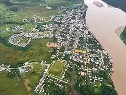 Aerial view of the town | |
 Flag  Seal | |
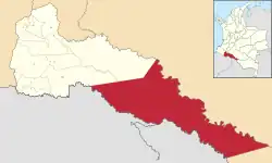 Location of the municipality and town of Puerto Leguízamo in the Putumayo Department of Colombia. | |
| Country | |
| Department | |
| Area | |
| • Municipality and town | 10,907 km2 (4,211 sq mi) |
| • Urban | 2.13 km2 (0.82 sq mi) |
| Elevation | 177 m (581 ft) |
| Population (2018 census)[1] | |
| • Municipality and town | 28,468 |
| • Density | 2.6/km2 (6.8/sq mi) |
| • Urban | 12,755 |
| • Urban density | 6,000/km2 (16,000/sq mi) |
| Time zone | UTC-5 (Colombia Standard Time) |
Its Catedral Nuestra Señora del Carmen, dedicated to Our Lady of Mount Carmel, is the cathedral episcopal see of the Latin Catholic missionary pre-diocesan Apostolic Vicariate of Puerto Leguízamo-Solano.
Puerto Leguízamo is served by Caucayá Airport.
Climate
Located just a few kilometres south of the equator, Puerto Leguízamo has a tropical rainforest climate (Af) with heavy to very heavy rainfall year-round.
| Climate data for Puerto Leguízamo | |||||||||||||
|---|---|---|---|---|---|---|---|---|---|---|---|---|---|
| Month | Jan | Feb | Mar | Apr | May | Jun | Jul | Aug | Sep | Oct | Nov | Dec | Year |
| Average high °C (°F) | 32.1 (89.8) |
31.8 (89.2) |
31.5 (88.7) |
30.6 (87.1) |
30.7 (87.3) |
29.5 (85.1) |
28.5 (83.3) |
30.5 (86.9) |
31.9 (89.4) |
30.3 (86.5) |
31.9 (89.4) |
30.7 (87.3) |
30.8 (87.5) |
| Daily mean °C (°F) | 27.4 (81.3) |
27.2 (81.0) |
26.6 (79.9) |
26.2 (79.2) |
26.3 (79.3) |
25.3 (77.5) |
24.7 (76.5) |
25.5 (77.9) |
26.4 (79.5) |
26.3 (79.3) |
27.2 (81.0) |
26.5 (79.7) |
26.3 (79.3) |
| Average low °C (°F) | 22.8 (73.0) |
22.7 (72.9) |
21.8 (71.2) |
21.9 (71.4) |
22.0 (71.6) |
21.2 (70.2) |
20.9 (69.6) |
20.6 (69.1) |
20.9 (69.6) |
22.4 (72.3) |
22.6 (72.7) |
22.3 (72.1) |
21.8 (71.3) |
| Average rainfall mm (inches) | 108 (4.3) |
175 (6.9) |
218 (8.6) |
307 (12.1) |
360 (14.2) |
377 (14.8) |
335 (13.2) |
276 (10.9) |
263 (10.4) |
250 (9.8) |
192 (7.6) |
131 (5.2) |
2,992 (118) |
| Source: Climate-Data.org[3] | |||||||||||||
References
- Citypopulation.de
- (in Spanish) Puerto Leguízamo official website Archived 2007-09-29 at the Wayback Machine
- "Climate: Puerto Leguízamo". Climate-Data.org. Retrieved August 9, 2020.
External links
- (in Spanish) Informacion Ambiental de la Amazonia colombiana
Municipalities in the Putumayo Department | ||
|---|---|---|
This article is issued from Wikipedia. The text is licensed under Creative Commons - Attribution - Sharealike. Additional terms may apply for the media files.