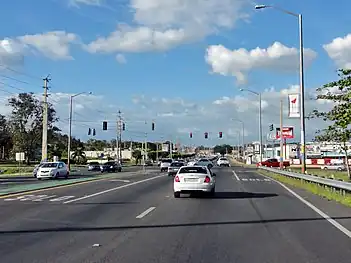
Puerto Rico Highway 100
Puerto Rico Highway 100 (PR-100) is a secondary highway in southwestern Puerto Rico, located mostly in the municipality of Cabo Rojo.[3]
Highway 100 | ||||
|---|---|---|---|---|
| Ruta 100 | ||||
| Avenida Antonio J. "Tony" Fas Alzamora[1] | ||||
| Route information | ||||
| Maintained by Puerto Rico DTPW | ||||
| Length | 16.3 km[2] (10.1 mi) | |||
| Major junctions | ||||
| South end | ||||
| ||||
| North end | ||||
| Location | ||||
| Country | United States | |||
| Territory | Puerto Rico | |||
| Municipalities | Cabo Rojo, Hormigueros | |||
| Highway system | ||||
| ||||
Route description
Beginning at its intersection with PR-2 in Hormigueros, Puerto Rico, the highway runs south for about 15 kilometers and is main gateway to local tourist destinations such as Boquerón, Combate (via PR-301 and PR-3301) and Puerto Real. It also connects PR-2 to PR-102. It is mostly divided, but in the end it is three lanes (2 to go and 1 returning, and later backwards). It ends at PR-301.[4]
 Puerto Rico Highway 100 in Cabo Rojo
Major intersections
| Municipality | Location | km[2] | mi | Destinations | Notes |
|---|---|---|---|---|---|
| Cabo Rojo | Boquerón | 16.3 | 10.1 | Southern terminus of PR-100; seagull intersection | |
| 15.0 | 9.3 | Eastern terminus of PR-101 concurrency; seagull intersection | |||
| 14.6 | 9.1 | Western terminus of PR-101 concurrency; seagull intersection | |||
| Pedernales | 9.9 | 6.2 | |||
| Pedernales–Miradero line | 8.3 | 5.2 | |||
| Miradero | 7.4– 7.3 | 4.6– 4.5 | |||
| Miradero–Guanajibo line | 4.6 | 2.9 | |||
| Guanajibo | 3.6 | 2.2 | |||
| Hormigueros | Guanajibo | 0.0 | 0.0 | Northern terminus of PR-100; PR-2 exit 161; trumpet interchange | |
1.000 mi = 1.609 km; 1.000 km = 0.621 mi
| |||||
References
- "Ley Núm. 75 de 2016 -Para designar la Carretera PR-100 y la Carretera PR-301 como "Avenida y Carretera Antonio J. "Tony" Fas Alzamora"". LexJuris (Leyes y Jurisprudencia) de Puerto Rico (in Spanish). Retrieved 1 June 2019.
- Google (3 March 2020). "PR-100" (Map). Google Maps. Google. Retrieved 3 March 2020.
- Puerto Rico Department of Transportation and Public Works. "Datos de Transito 2000-2009" (in Spanish). Archived from the original on 1 April 2019. Retrieved 23 April 2019.
- National Geographic Maps (2011). Puerto Rico (Map). 1:125,000. Adventure Map (Book 3107). Evergreen, Colorado: National Geographic Maps. ISBN 978-1566955188. OCLC 756511572.
This article is issued from Wikipedia. The text is licensed under Creative Commons - Attribution - Sharealike. Additional terms may apply for the media files.
