Puerto Rico Highway 107
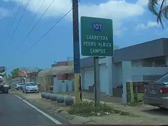
Puerto Rico Highway 107 (PR-107), or Carretera Pedro Albizu Campos,[2] is a north–south highway located in Aguadilla, Puerto Rico.[3][4] It extends from PR-2 to Ramey Air Force Base.[5]
 Puerto Rico Highway 107 north near Crash Boat Beach
Highway 107 | ||||
|---|---|---|---|---|
| Ruta 107 | ||||
| Carretera Pedro Albizu Campos | ||||
| Route information | ||||
| Maintained by Puerto Rico DTPW | ||||
| Length | 4.5 km[1] (2.8 mi) | |||
| Major junctions | ||||
| South end | ||||
| North end | Borinquen Road in Borinquen–Camaceyes | |||
| Location | ||||
| Country | United States | |||
| Territory | Puerto Rico | |||
| Municipalities | Aguadilla | |||
| Highway system | ||||
| ||||
| ||||
Major intersections
The entire route is located in Aguadilla.
| Location | km[1] | mi | Destinations | Notes | |
|---|---|---|---|---|---|
| Caimital Bajo | 0.0 | 0.0 | Southern terminus of PR-107 | ||
| Caimital Bajo–Camaceyes line | 0.1– 0.2 | 0.062– 0.12 | Northern terminus of PR-1107 (former PR-111); access to Aguadilla Centro | ||
| Camaceyes–Borinquen line | 0.5– 0.6 | 0.31– 0.37 | Access to Aguadilla Centro | ||
| Borinquen | 0.9 | 0.56 | Clockwise terminus of PR-467 | ||
| 1.9– 2.0 | 1.2– 1.2 | Eastern terminus of PR-458 | |||
| Borinquen–Camaceyes line | 4.1 | 2.5 | Western terminus of PR-4467 | ||
| 4.5 | 2.8 | Ramey Air Force Base (Borinquen Road) | Northern terminus of PR-107 | ||
1.000 mi = 1.609 km; 1.000 km = 0.621 mi
| |||||
Related route
Highway 1107 | |
|---|---|
| Location | Aguadilla |
| Length | 6.3 km[6] (3.9 mi) |
Puerto Rico Highway 1107 (PR-1107) is a north–south spur route that connects PR-107 with downtown Aguadilla. This highways extends from PR-107 between Camaceyes and Caimital Bajo barrios until its end at PR-2 and PR-111 in Victoria. This highway was part of PR-111 and is designated as Carretera Doctor Gregorio Igartúa Acevedo.[7][8] The entire route is located in Aguadilla.
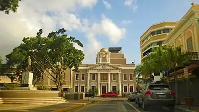
 PR-1107 south in downtown Aguadilla
 PR-1107 south at PR-460 intersection between Camaceyes and Caimital Bajo barrios
| Location | km[6] | mi | Destinations | Notes | |
|---|---|---|---|---|---|
| Victoria | 6.3 | 3.9 | Partial cloverleaf interchange; southern terminus of PR-1107 and western terminus of PR-111 | ||
| 6.2– 6.1 | 3.9– 3.8 | Northern terminus of PR-418 | |||
| 6.0 | 3.7 | Northern terminus of PR-4439 | |||
| 5.9 | 3.7 | Northern terminus of PR-115 | |||
| Aguadilla barrio-pueblo | 4.0 | 2.5 | Northern terminus of PR-4440 | ||
| 3.8 | 2.4 | PR-4442 | Northern terminus of PR-4442; unsigned | ||
| 3.6 | 2.2 | Southern terminus of PR-440 | |||
| 3.1– 3.0 | 1.9– 1.9 | Former PR-2R | |||
| 2.8– 2.7 | 1.7– 1.7 | Northern terminus of PR-440 | |||
| 2.2 | 1.4 | Southern terminus of PR-460 | |||
| Aguadilla barrio-pueblo–Camaceyes– Borinquen tripoint | 1.7– 1.6 | 1.1– 0.99 | Southern terminus of PR-4458 | ||
| Camaceyes–Caimital Bajo line | 0.3– 0.2 | 0.19– 0.12 | Northern terminus of PR-460 | ||
| 0.0 | 0.0 | Northern terminus of PR-1107; access to Arecibo, San Juan, Mayagüez and Ramey Air Force Base | |||
| 1.000 mi = 1.609 km; 1.000 km = 0.621 mi | |||||
References
- Google (2 March 2020). "PR-107" (Map). Google Maps. Google. Retrieved 2 March 2020.
- "Av. Dr. Pedro Albizu Campos & PR-107". Google maps.
- National Geographic Maps (2011). Puerto Rico (Map). 1:125,000. Adventure Map (Book 3107). Evergreen, Colorado: National Geographic Maps. ISBN 978-1566955188. OCLC 756511572.
- "Listado NHS2008(Muestras).xls" (PDF). DTOP gov't of P.R. 5 November 2010. Archived from the original (PDF) on 5 November 2010.
- "Tránsito Promedio Diario (AADT)". Transit Data (Datos de Transito) (in Spanish). DTOP PR. p. 58. Archived from the original on 1 April 2019.
- Google (8 April 2023). "PR-1107" (Map). Google Maps. Google. Retrieved 8 April 2023.
- "PR-111, Barrio Pueblo". mapio.net. Retrieved 9 April 2023.
- "Resolución Conjunta Para denominar con el nombre del "Dr. Gregorio Igartúa Acevedo" la Carretera PR-1107 desde el Km.0.0, intersección con la Carretera PR-107 hasta el Km.6.30, intersección con las Carreteras PR-2 y PR-111 del Municipio de Aguadilla; y para otros fines relacionados". Cámara de Representantes de Puerto Rico (in Spanish). Retrieved 8 April 2023.
External links
Wikimedia Commons has media related to Puerto Rico Highway 107 and Puerto Rico Highway 1107.
This article is issued from Wikipedia. The text is licensed under Creative Commons - Attribution - Sharealike. Additional terms may apply for the media files.

