Black Rocks at Pungo Andongo
The Black Rocks at Pungo Andongo (Pedras Negras de Pungo Andongo) are a set of extensive monolithic rock formations, millions of years old, that stand out for their size in relation to the savanna landscape of the region.[1] It is subdivided into Western, South, North and Southeast subsystems. The formation is an extension of the Cacuso Plateau.[2]
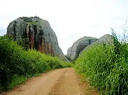
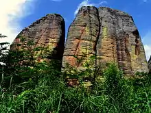
The western rocky subsystem, the best known and most visited of all, is located in the municipality of Cacuso, in Malanje Province, and is an important tourist attraction in Angola.[3]
According to tradition, the footprints carved into the rock belong to Ana de Sousa Ginga of Ndongo and Matamba, the great monarch of the kingdom of Ndongo.[4]
The commune of Pungo-Andongo is located in the center of the western subsystem of the formation. During its last years, this town was the capital of the Kingdom of Ndongo. In 1671 the Portuguese besieged and captured the city, enslaving many of its inhabitants and destroying the kingdom.[5] The ruins of the Fortress of Pungo-Andongo, built by the Portuguese after the battle, are located in the modern town.[6]
References
- Oyebade, Adebayo (2006). Culture and Customs of Angola. Greenwood Publishing Group. p. 102. ISBN 978-0-313-01529-8. Retrieved 2008-10-03.
- Diniz, A. Castanheira.; Aguiar, F. de Barros.. Zonagem Agro-Ecológica de Angola: estudo cobrindo 200 000 Km2 do território. Lisboa - Porto: Instituto da Cooperação Portuguesa; Fundação Portugal-África; Fundo da EFTA para o Desenvolvimento Industrial em Portugal. 1998.
- Património histórico angolano deixado ao abandono. VOA Português. 23 April 2017.
- "Prime Minister Ends Visit to Pungo-Andongo". Angola Press Agency. 10 July 2008. Retrieved 2008-10-03.
- Angola - The Defeat of Kongo and Ndongo, Country Studies US
- Livingstone, David (1858). Missionary Travels and Researches in South Africa. Harper & Bros. pp. 456. Retrieved 2008-10-03.
Pungo Andongo +fort.