Mexico City Metro Line A
Mexico City Metro Line A is one of the twelve metro lines operating in Mexico City, Mexico. The line's color is purple. It was the ninth line to be opened.
| Line A / Línea A | |||||||||||||||||||||||||||||||||||||||||||||||||||||||||||||||||||||||||||||||||||||||||||||||||
|---|---|---|---|---|---|---|---|---|---|---|---|---|---|---|---|---|---|---|---|---|---|---|---|---|---|---|---|---|---|---|---|---|---|---|---|---|---|---|---|---|---|---|---|---|---|---|---|---|---|---|---|---|---|---|---|---|---|---|---|---|---|---|---|---|---|---|---|---|---|---|---|---|---|---|---|---|---|---|---|---|---|---|---|---|---|---|---|---|---|---|---|---|---|---|---|---|---|
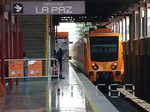
 FE-07 at the Agrícola Oriental station. | |||||||||||||||||||||||||||||||||||||||||||||||||||||||||||||||||||||||||||||||||||||||||||||||||
| Overview | |||||||||||||||||||||||||||||||||||||||||||||||||||||||||||||||||||||||||||||||||||||||||||||||||
| Locale | Mexico City | ||||||||||||||||||||||||||||||||||||||||||||||||||||||||||||||||||||||||||||||||||||||||||||||||
| Termini | |||||||||||||||||||||||||||||||||||||||||||||||||||||||||||||||||||||||||||||||||||||||||||||||||
| Connecting lines | |||||||||||||||||||||||||||||||||||||||||||||||||||||||||||||||||||||||||||||||||||||||||||||||||
| Stations | 10 | ||||||||||||||||||||||||||||||||||||||||||||||||||||||||||||||||||||||||||||||||||||||||||||||||
| Service | |||||||||||||||||||||||||||||||||||||||||||||||||||||||||||||||||||||||||||||||||||||||||||||||||
| Type | Rapid transit | ||||||||||||||||||||||||||||||||||||||||||||||||||||||||||||||||||||||||||||||||||||||||||||||||
| System | Mexico City Metro | ||||||||||||||||||||||||||||||||||||||||||||||||||||||||||||||||||||||||||||||||||||||||||||||||
| Operator(s) | Sistema de Transporte Colectivo (STC) | ||||||||||||||||||||||||||||||||||||||||||||||||||||||||||||||||||||||||||||||||||||||||||||||||
| Rolling stock | FM-86, FM-95A, FE-07 | ||||||||||||||||||||||||||||||||||||||||||||||||||||||||||||||||||||||||||||||||||||||||||||||||
| Ridership | 307,639 passengers per day (2019)[1] | ||||||||||||||||||||||||||||||||||||||||||||||||||||||||||||||||||||||||||||||||||||||||||||||||
| History | |||||||||||||||||||||||||||||||||||||||||||||||||||||||||||||||||||||||||||||||||||||||||||||||||
| Opened | 12 August 1991[2] | ||||||||||||||||||||||||||||||||||||||||||||||||||||||||||||||||||||||||||||||||||||||||||||||||
| Technical | |||||||||||||||||||||||||||||||||||||||||||||||||||||||||||||||||||||||||||||||||||||||||||||||||
| Line length | 14.893 km (9 mi) | ||||||||||||||||||||||||||||||||||||||||||||||||||||||||||||||||||||||||||||||||||||||||||||||||
| Track length | 17.192 km (11 mi) | ||||||||||||||||||||||||||||||||||||||||||||||||||||||||||||||||||||||||||||||||||||||||||||||||
| Track gauge | 1,435 mm (4 ft 8+1⁄2 in) standard gauge | ||||||||||||||||||||||||||||||||||||||||||||||||||||||||||||||||||||||||||||||||||||||||||||||||
| Electrification | Overhead line | ||||||||||||||||||||||||||||||||||||||||||||||||||||||||||||||||||||||||||||||||||||||||||||||||
| |||||||||||||||||||||||||||||||||||||||||||||||||||||||||||||||||||||||||||||||||||||||||||||||||
The line was opened in 1983 and it runs from eastern Mexico City southeast into the State of Mexico. Line A has 10 stations and a length of 17.192 km (10.683 mi), out of which 14.893 km (9.254 mi) are for service. It was the second line to service the State of Mexico, after the Cuatro Caminos station of the Line 2, opened in 1984.
History
Line A was inaugurated on August 12, 1991 by Carlos Salinas de Gortari, President of Mexico from 1988 to 1994, Manuel Camacho Solís, Head of the Federal District Department from 1988 to 1993, and Ignacio Pichardo Pagaza, Governor of the State of Mexico from 1989 to 1993.
Line A was conceived as a feeder line, thus, instead of using a number (which, in this case, it would have been 10 – Line 10), it used a letter in its denomination. The line was designed to connect Mexico City to the State of Mexico. For this reason, until December 2013, it was necessary to pay another fare when commuting from Line A to Lines 1, 5 and 9 at Pantitlán station.[3][4]
Another feeder line, also connecting the State of Mexico to Mexico City, would be inaugurated in 1999: Line B, also using a letter instead of a number to designate it.
A proposed extension of the line was presented in 2018 by the Sistema de Transporte Colectivo. According to the plan, Line A would be expanded southbound towards Chalco in the State of Mexico. The stretch would have six new stations and a length of 13.19 km (8.20 mi).[5]
Rolling stock
Line A has had different types of rolling stock throughout the years.
Currently, out of the 390 trains in the Mexico City Metro network, 17 are in service in Line A.[6]
Station list
| Denotes a partially accessible station | |
| Denotes a fully accessible station | |
| Denotes a metro transfer | |
| Denotes a connection with the Cablebús system | |
| Denotes a connection with the Centro de transferencia modal (CETRAM) system. In the State of Mexico, they are called Estación de tranferencia modal (ETRAM). | |
| Denotes a connection with the Metrobús system | |
| Denotes a connection with the Mexibús system | |
| Denotes a connection with the public bus system | |
| Denotes a connection with the Red de Transporte de Pasajeros (RTP) system | |
| Denotes a connection with the Trolleybus system |
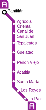
The stations from east to west:


| No. | Station | Date opened | Level | Distance (km) | Connection | Location | ||
|---|---|---|---|---|---|---|---|---|
| Between stations |
Total | |||||||
| 01 | Pantitlán |
12 August 1991 | Underground | - | 0.0 |
|
Iztacalco / Venustiano Carranza | Mexico City |
| 02 | Agrícola Oriental | Grade-level, overground access | 1.6 | 1.6 |
|
Iztacalco | ||
| 03 | Canal de San Juan | 1.2 | 2.8 |
| ||||
| 04 | Tepalcates |
1.6 | 4.4 |
|
Iztapalapa | |||
| 05 | Guelatao | 1.3 | 5.7 |
| ||||
| 06 | Peñón Viejo | 2.4 | 8.1 |
| ||||
| 07 | Acatitla | 1.5 | 9.6 |
| ||||
| 08 | Santa Marta |
1.3 | 10.9 |
| ||||
| 09 | Los Reyes | 1.9 | 12.8 | La Paz | State of Mexico | |||
| 10 | La Paz |
2.1 | 14.9 |
| ||||
Ridership
The following table shows each of Line 6 stations total and average daily ridership during 2019.[1]
| ‡ | Terminal |
| †‡ | Transfer station and terminal |
| Rank | Station | Total ridership | Average daily |
|---|---|---|---|
| 1 | Pantitlán†‡ | 45,550,938 | 124,797 |
| 2 | La Paz‡ | 15,636,790 | 42,841 |
| 3 | Santa Marta | 10,088,191 | 27,639 |
| 4 | Guelatao | 7,898,506 | 21,640 |
| 5 | Tepalcates | 7,054,067 | 19,326 |
| 6 | Los Reyes | 6,242,517 | 17,103 |
| 7 | Acatitla | 5,846,455 | 16,018 |
| 8 | Peñón Viejo | 5,025,958 | 13,770 |
| 9 | Canal de San Juan | 4,813,813 | 13,189 |
| 10 | Agrícola Oriental | 4,130,829 | 11,317 |
| Total | 112,288,064 | 307,639 | |
See also
Notes
- The following list was adapted from different websites and official maps.
- Metro (
_version_2019.svg.png.webp) ) connections obtained from the official Mexico City Metro system map.[7]
) connections obtained from the official Mexico City Metro system map.[7] - Accessibility obtained from the Mexico City Metro system map. In some cases, the map omits the accessibility icon as the station(s) are actually partially accessible. However, the respective websites of each station on the official site indicate the respective accessibility methods. Stations with the symbol
 ‡ are fully accessible; stations with the symbol
  † are partially accessible.[7]
 - Cablebús (
 ) obtained from their official website.[8]
 - Centro de transferencia modal (CETRAM;
_%C3%93rgano_Regulador_de_Transporte_(CETRAM).svg.png.webp) ) obtained from the official website of the Órgano Regulador de Transporte.[9]
) obtained from the official website of the Órgano Regulador de Transporte.[9] - Metrobús (
 ) obtained from the Mexico City Metrobús system map.[10]
 - Mexibús (
.svg.png.webp) ) obtained from the official Mexico City Metro system map.[7]
) obtained from the official Mexico City Metro system map.[7] - Public buses network (peseros) (
_Red_de_Autobuses_de_la_CDMX.svg.png.webp) ) obtained from the official website of the Órgano Regulador de Transporte.[11]
) obtained from the official website of the Órgano Regulador de Transporte.[11] - Red de Transporte de Pasajeros (
 ) obtained from their official website.[12]
 - Trolleybuses (
 ) obtained from their official website.[8]
- Metro (
References
- "Afluencia de estación por línea 2019" (in Spanish). Metro CDMX. Retrieved 26 April 2020.
- "Línea A 2017". MetroCDMX. Retrieved 11 August 2018.
- "Elimina STC el doble pago para usuarios de la Línea "A" al retirar Torniquetes de Transbordo en Pantitlán" (in Spanish). Metro CDMX. 13 December 2013. Retrieved 13 August 2018.
- "Este viernes, retiran torniquetes de Línea A del Metro". Milenio (in Spanish). 12 December 2013. Retrieved 13 August 2018.
- Sistema de Transporte Colectivo. "Plan Maestro del Metro 2018–2030" (PDF) (in Spanish). p. 49. Retrieved 26 April 2020.
- CDMX, Metro. "Parque Vehicular". Metro CDMX. Retrieved 11 August 2018.
- "Mi Mapa Metro 22032021" [My Metro Map 22032021] (PDF) (in Spanish). Sistema Transporte Colectivo Metro. 22 March 2021. Retrieved 30 October 2021.
- "Servicios" [Services] (in Spanish). Servicio de Transportes Eléctricos. Retrieved 30 October 2021.
- "Centros de Transferencia Modal (CETRAM)" [Modal Transfer Centers] (in Spanish). Órgano Regulador de Transporte. Retrieved 30 October 2021.
- "Mapa del sistema" [System map] (in Spanish). Mexico City Metrobús. Retrieved 30 October 2021.
- "Red de corredores" [Route network] (in Spanish). Retrieved 30 October 2021.
- "Red de Rutas" [Routes network] (in Spanish). Red de Transporte de Pasajeros. Retrieved 30 October 2021.