Shire of Pyrenees
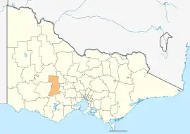
The Shire of Pyrenees is a local government area (LGA) in Victoria, Australia, located in the western part of the state. It covers an area of 3,435 square kilometres (1,326 sq mi) and in June 2018 had a population of 7,353.[1]
| Shire of Pyrenees Victoria | |||||||||||||||
|---|---|---|---|---|---|---|---|---|---|---|---|---|---|---|---|
 Location in Victoria | |||||||||||||||
| Population | 7,671 (2021)[1] | ||||||||||||||
| • Density | 2.2332/km2 (5.7839/sq mi) | ||||||||||||||
| Established | 1994 | ||||||||||||||
| Gazetted | 23 September 1994[2] | ||||||||||||||
| Area | 3,435 km2 (1,326.3 sq mi)[1] | ||||||||||||||
| Mayor | Cr Tanya Kehoe | ||||||||||||||
| Council seat | Beaufort | ||||||||||||||
| Region | Grampians | ||||||||||||||
| State electorate(s) | Ripon | ||||||||||||||
| Federal division(s) | |||||||||||||||
| Website | Shire of Pyrenees | ||||||||||||||
| |||||||||||||||
It includes the towns of Avoca, Beaufort, Lexton and Trawalla. It was formed in 1994 from the amalgamation of the Shire of Avoca, Shire of Lexton and Shire of Ripon.[2][3]
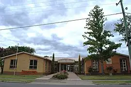
The Shire is governed and administered by the Pyrenees Shire Council; its seat of local government and administrative centre is located at the council headquarters in Beaufort, it also has a service centre located in Avoca. The Shire is named after the major geographical feature in the region, The Pyrenees Ranges which also gives its name to the Pyrenees wine region, which is located in the north of the Local Government Area.
Council
Current composition
The council is composed of five wards and five councillors, with one councillor per ward elected to represent each ward.[4] Council Composition as of September 2022:
| Ward | Councillor | Notes | |
|---|---|---|---|
| Avoca | Ron Eason | Mayor | |
| Beaufort | Damian Ferrari | ||
| De Cameron | Robert Vance | ||
| Ercildoune | David Clark | ||
| Mount Emu | Tanya Kehoe | ||
Administration and governance
The council meets in the council chambers at the council headquarters in the Beaufort Municipal Offices, which is also the location of the council's administrative activities. It also provides customer services at both its administrative centre in Beaufort, and its service centre in Avoca.
Traditional owners
The traditional owners of this land are the Wadawurrung, Dja Dja Wurrung, Wotjobaluk and Eastern Maar.[5]
Townships and localities
The 2021 census, the shire had a population of 7,671 up from 7,238 in the 2016 census[6]
| Population | ||
|---|---|---|
| Locality | 2016 | 2021 |
| Amphitheatre | 248 | 223 |
| Avoca | 1,193 | 1,356 |
| Barkly^ | 43 | 49 |
| Beaufort | 1,539 | 1,712 |
| Bo Peep^ | 21 | 25 |
| Brewster | 51 | 47 |
| Buangor^ | 103 | 112 |
| Bung Bong^ | 51 | 63 |
| Burnbank | 59 | 47 |
| Burrumbeet^ | 232 | 249 |
| Carngham | 146 | 171 |
| Carranballac^ | 42 | 43 |
| Chepstowe | 61 | 60 |
| Chute | 18 | 13 |
| Cross Roads | 19 | 27 |
| Crowlands^ | 89 | 72 |
| Elmhurst^ | 183 | 185 |
| Population | ||
|---|---|---|
| Locality | 2016 | 2021 |
| Ercildoune^ | 70 | 90 |
| Evansford^ | 131 | 147 |
| Eversley^ | 10 | 14 |
| Frenchmans | 13 | 7 |
| Glenbrae | 30 | 30 |
| Glenlofty | 17 | 11 |
| Glenlogie^ | 33 | 29 |
| Glenpatrick | 31 | 13 |
| Hillcrest | 95 | 99 |
| Homebush | 36 | 31 |
| Lake Goldsmith | 29 | 22 |
| Lake Wongan | 8 | 3 |
| Lamplough | 61 | 49 |
| Landsborough | 180 | 200 |
| Landsborough West^ | 41 | 49 |
| Langi Kal Kal | 400 | 336 |
| Lexton | 231 | 284 |
| Population | ||
|---|---|---|
| Locality | 2016 | 2021 |
| Lillicur^ | 29 | 85 |
| Linton^ | 580 | 635 |
| Main Lead | 46 | 42 |
| Mena Park | 27 | 32 |
| Middle Creek^ | 19 | 22 |
| Moonambel | 167 | 185 |
| Mount Emu | 26 | 28 |
| Mount Lonarch | 42 | 44 |
| Natte Yallock^ | 94 | 89 |
| Navarre^ | 98 | 99 |
| Nerring | 15 | 14 |
| Nowhere Creek | 17 | 20 |
| Percydale | 39 | 22 |
| Pittong^ | 15 | 12 |
| Raglan | 231 | 223 |
| Rathscar^ | 21 | 19 |
| Population | ||
|---|---|---|
| Locality | 2016 | 2021 |
| Rathscar West | 23 | 31 |
| Redbank^ | 94 | 102 |
| Shays Flat^ | 13 | 3 |
| Skipton^ | 586 | 609 |
| Smythesdale^ | 1,032 | 1,189 |
| Snake Valley | 743 | 820 |
| Stockyard Hill | 49 | 49 |
| Stoneleigh^ | 45 | 45 |
| Streatham^ | 156 | 158 |
| Tanwood | 26 | 15 |
| Trawalla | 141 | 140 |
| Wareek^ | 68 | 72 |
| Warrenmang | 17 | 16 |
| Waterloo | 110 | 122 |
| Wattle Creek^ | 0 | 0 |
| Waubra^ | 275 | 308 |
^ - Territory divided with another LGA
References
- "3218.0 – Regional Population Growth, Australia, 2017-18: Population Estimates by Local Government Area (ASGS 2018), 2017 to 2018". Australian Bureau of Statistics. Australian Bureau of Statistics. 27 March 2019. Retrieved 25 October 2019. Estimated resident population, 30 June 2018.
- Victoria Government Gazette – Online Archive (1837–1997). "S63 of 1994: Order estg the Shire of Pyrenees". State Library of Victoria. State Government of Victoria (published 23 September 1994). pp. 16–23. Retrieved 10 January 2014.
- Victoria Government Gazette – Online Archive (1837–1997). "S4 of 1995: Order altg (Part 12) the Shire of Pyrenees". State Library of Victoria. State Government of Victoria (published 20 January 1995). p. 5. Retrieved 10 January 2014.
- Victorian Electoral Commission. "Pyrenees Shire Council election results 2020". Retrieved 13 September 2022.
- "Reconciliation". www.pyrenees.vic.gov.au. Retrieved 1 May 2021.
- "Census | Australian Bureau of Statistics". www.abs.gov.au. 11 January 2023.
External links
- Pyrenees Shire Council official website
- Metlink local public transport map
- Link to Land Victoria interactive maps
- Avoca and District Historical Society Inc
- https://web.archive.org/web/20110203095139/http://www.moonambel-pyrenees.com/
Localities in the Shire of Pyrenees | ||
|---|---|---|
| Town | 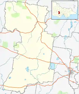 | |
| Locality |
| |
^ - Territory divided with another LGA | ||