Qingyuan Manchu Autonomous County
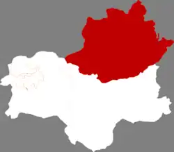
Qingyuan Manchu Autonomous County (simplified Chinese: 清原满族自治县; traditional Chinese: 清原滿族自治縣; pinyin: Qīngyuán Mǎnzú Zìzhìxiàn, Manchu: ᠴᡳᠩᠶᡠᠸᠠᠨ ᠮᠠᠨᠵᡠ ᠪᡝᠶᡝ ᡩᠠᠰᠠᠩᡤᠠ ᠰᡳᠶᠠᠨ; Möllendorff: cingyuwan manju beye dasangga siyan), or simply Qingyuan County (清原县) is one of the three counties under the administration of the prefecture-level city of Fushun, in the east of Liaoning, China, and is also one of the 11 Manchu autonomous counties and one of 117 autonomous counties nationally. It has a population of about 340,000, covering an area of 3,921 square kilometres (1,514 sq mi).
Qingyuan
清原县 ᠴᡳᠩᠶᡠᠸᠠᠨ ᠰᡳᠶᠠᠨ | |
|---|---|
清原满族自治县 ᠴᡳᠩᠶᡠᠸᠠᠨ ᠮᠠᠨᠵᡠ ᠪᡝᠶᡝ ᡩᠠᠰᠠᠩᡤᠠ ᠰᡳᠶᠠᠨ Qingyuan Manchu Autonomous County | |
 Qingyuan in Fushun | |
.png.webp) Fushun in Liaoning | |
| Coordinates: 42°06′02″N 124°55′27″E | |
| Country | China |
| Province | Liaoning |
| Prefecture-level city | Fushun |
| County seat | Qingyuan |
| Area | |
| • Total | 3,921 km2 (1,514 sq mi) |
| Elevation | 238 m (781 ft) |
| Population (2020 census)[1] | |
| • Total | 238,890 |
| • Density | 61/km2 (160/sq mi) |
| Time zone | UTC+8 (China Standard) |
| Postal code | 113300 |
| Area code | 0413 |
| Website | www |
Administrative divisions
There are 10 towns and 4 townships in the county.[2]
| Name | Simplified Chinese | Hanyu Pinyin | Manchu | Möllendorff | Administrative division code |
|---|---|---|---|---|---|
| Towns | |||||
| Qingyuan | 清源镇 | Qīngyuán zhèn | ᠴᡳᠩ ᠶᡠᠸᠠᠨ ᠵᡝᠨ | cing yuwan jen | 210423100 |
| Hongtoushan | 红透山镇 | Hóngtòushān zhèn | ᡥᡡᠩ ᡨᠣᠣ ᡧᠠᠨ ᠵᡝᠨ | hūng too šan jen | 210423101 |
| Caoshi | 草市镇 | Cǎoshì zhèn | ᡮᠣᠣ ᡧᡳ ᠵᡝᠨ | tsʹoo ši jen | 210423103 |
| Ying'emen | 英额门镇) | Yīng'émén zhèn | ᠸᡝᠩᡤᡝ ᠸᠠᠰᡝ ᠵᡝᠨ | wengge wase jen | 210423104 |
| Nankouqian | 南口前镇 | Nánkǒuqián zhèn | ᠵᡠᠯᡝᡵᡤᡳ ᡴᠣᡴᡳ ᠵᡝᠨ | julergi koki jen | 210423105 |
| Nanshancheng | 南山城镇 | Nánshānchéng zhèn | ᠨᠠᠨ ᡧᠠᠨ ᠴᡝᠩ ᠵᡝᠨ | nan šan ceng jen | 210423106 |
| Wandianzi | 湾甸子镇 | Wāndiànzi zhèn | ᠸᠠᠨ ᡩᡳᠶᠠᠨ ᡯᡳ᠌ ᠵᡝᠨ | wan diyan dzi jen | 210423107 |
| Dagujia | 大孤家镇 | Dàgūjiā zhèn | ᡩᠠ ᡤᡠ ᠵᡳᠶᠠ ᠵᡝᠨ | da gu jiya jen | 210423108 |
| Xiajiabao | 夏家堡镇 | Xiàjiābǎo zhèn | ᠰᡳᠶᠠ ᠵᡳᠶᠠ ᡦᡡ ᠵᡝᠨ | siya jiya pū jen | 210423109 |
| Beisanjia | 北三家镇 | Běisānjiā zhèn | ᠪᡝᡳ ᠰᠠᠨ ᠵᡳᠶᠠ ᠵᡝᠨ | bei san jiya jen | 210423110 |
| Townships | |||||
| Tukouzi Township | 土口子乡 | Tǔkǒuzi xiāng | ᡨᠣ᠋ ᡴᡝᠣ ᡯᡳ᠌ ᡤᠠᡧᠠᠨ | to keo dzi gašan | 210423203 |
| Aojiabao Township | 敖家堡乡 | Àojiāpǔ Xiāng | ᡠᠰᡳᡥᠠ ᡦᡠᡯ ᡤᠠᡧᠠᠨ | usiha pudzi gašan | 210423206 |
| Dasuhe Township | 大苏河乡 | Dàsūhé Xiāng | ᡩᠠ ᠰᡠ ᡥᡝ ᡤᠠᡧᠠᠨ | da su he gašan | 210423207 |
| Gounai Township | 枸乃甸乡 | Gǒunǎidiàn Xiāng | ᡤᠣ ᠨᠠᡳ ᡩᡳᠶᠠᠨ ᡤᠠᡧᠠᠨ | go nai diyan gašan | 210423208 |
Geography and climate
Qingyuan is located in the north of Fushun City. It spans 41°48′−42°29′ N latitude and 124°20′−125°29′ E longitude. Bordering county-level divisions are as follows:
In Liaoning:
- Xinbin Manchu Autonomous County – south
- Fushun County – west
- Tieling County – west
- Xifeng County – north
- Kaiyuan – north
In Jilin:
- Dongfeng County – east
- Meihekou – east
- Liuhe County – east
Qingyuan has a monsoon-influenced humid continental climate (Köppen Dwa), characterised by hot, humid summers and long, cold and windy, but dry winters. The four seasons here are distinctive. Over 60% of the annual rainfall of 774 mm (30.5 in) occurs from June to August alone. The monthly 24-hour average temperature ranges from −14.3 °C (6.3 °F) in January to 23.1 °C (73.6 °F) in July, and the annual mean is 6.2 °C (43.2 °F). In winter, due to the elevation and normally dry climate, diurnal temperature variation regularly exceeds 15 °C (27 °F).
| Climate data for Qingyuan (1991–2020 normals, extremes 1971–2010) | |||||||||||||
|---|---|---|---|---|---|---|---|---|---|---|---|---|---|
| Month | Jan | Feb | Mar | Apr | May | Jun | Jul | Aug | Sep | Oct | Nov | Dec | Year |
| Record high °C (°F) | 6.6 (43.9) |
15.5 (59.9) |
21.0 (69.8) |
30.2 (86.4) |
34.0 (93.2) |
36.7 (98.1) |
37.2 (99.0) |
37.1 (98.8) |
32.0 (89.6) |
29.0 (84.2) |
21.3 (70.3) |
11.5 (52.7) |
37.2 (99.0) |
| Average high °C (°F) | −5.6 (21.9) |
−0.8 (30.6) |
6.4 (43.5) |
16.2 (61.2) |
23.0 (73.4) |
27.0 (80.6) |
29.2 (84.6) |
28.2 (82.8) |
23.5 (74.3) |
15.6 (60.1) |
4.8 (40.6) |
−3.8 (25.2) |
13.6 (56.6) |
| Daily mean °C (°F) | −14.1 (6.6) |
−9.1 (15.6) |
−0.6 (30.9) |
8.5 (47.3) |
15.4 (59.7) |
20.4 (68.7) |
23.5 (74.3) |
22.1 (71.8) |
15.7 (60.3) |
7.4 (45.3) |
−2.1 (28.2) |
−11.3 (11.7) |
6.3 (43.4) |
| Average low °C (°F) | −20.6 (−5.1) |
−15.8 (3.6) |
−6.6 (20.1) |
1.5 (34.7) |
8.4 (47.1) |
14.6 (58.3) |
18.9 (66.0) |
17.6 (63.7) |
9.9 (49.8) |
1.2 (34.2) |
−7.5 (18.5) |
−17.1 (1.2) |
0.4 (32.7) |
| Record low °C (°F) | −36.3 (−33.3) |
−31.2 (−24.2) |
−23.1 (−9.6) |
−10.3 (13.5) |
−2.5 (27.5) |
5.2 (41.4) |
10.4 (50.7) |
5.3 (41.5) |
−3.2 (26.2) |
−12.2 (10.0) |
−25.4 (−13.7) |
−31.7 (−25.1) |
−36.3 (−33.3) |
| Average precipitation mm (inches) | 6.0 (0.24) |
11.0 (0.43) |
19.4 (0.76) |
39.7 (1.56) |
61.9 (2.44) |
108.8 (4.28) |
189.2 (7.45) |
190.9 (7.52) |
56.1 (2.21) |
49.9 (1.96) |
26.9 (1.06) |
12.3 (0.48) |
772.1 (30.39) |
| Average precipitation days (≥ 0.1 mm) | 5.2 | 4.9 | 6.8 | 8.6 | 11.1 | 14.1 | 14.2 | 13.2 | 8.5 | 8.3 | 8.1 | 6.6 | 109.6 |
| Average snowy days | 9.9 | 7.4 | 7.9 | 2.7 | 0 | 0 | 0 | 0 | 0 | 1.4 | 7.8 | 10 | 47.1 |
| Average relative humidity (%) | 70 | 65 | 60 | 54 | 61 | 71 | 79 | 82 | 77 | 70 | 70 | 72 | 69 |
| Mean monthly sunshine hours | 171.4 | 188.1 | 220.0 | 221.2 | 240.8 | 216.9 | 191.4 | 199.1 | 217.0 | 198.9 | 155.5 | 152.3 | 2,372.6 |
| Percent possible sunshine | 58 | 63 | 59 | 55 | 53 | 48 | 42 | 47 | 59 | 59 | 53 | 54 | 54 |
| Source 1: China Meteorological Administration[3][4] | |||||||||||||
| Source 2: Weather China[5] | |||||||||||||
References
- "抚顺市第七次全国人口普查公报(第二号)" (in Chinese). Fushun Municipal Bureau of Statistics. 2021-11-08.
- 2022年统计用区划代码和城乡划分代码:清原满族自治县 (in Chinese). National Bureau of Statistics of the People's Republic of China.
- 中国气象数据网 – WeatherBk Data (in Simplified Chinese). China Meteorological Administration. Retrieved 29 July 2023.
- 中国气象数据网 (in Simplified Chinese). China Meteorological Administration. Retrieved 29 July 2023.
- 清原 - 气象数据 -中国天气网 (in Chinese). Weather China. Retrieved 24 September 2022.


