Queslett
Queslett is an area of Great Barr, Birmingham, England.

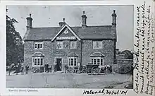
The name (originally Quieslade) has been in use since the 16th century. The first part, from "Queest", means a wood pigeon,[1] the second comes from the Anglo-Saxon "slade", for a small valley.[2] Another old spelling, Queeslet, appears on Victorian maps and postcards.

The area was part of Staffordshire until 1928.
In 1810, in A Complete History of the Druids, T G Lomax described the area:[3]
At the declivity of very pleasingly diversified hills, near Quieslade, is a most delightful lake, by crossing the head of which, the admirer of variegated landscape will be amply rewarded by an agreeable range over the opposite hills, where the High-Wood and Barr Beacon present themselves to view; and by gradually climbing the first of these two summits, the south-east prospect becomes very rich and extensive; and the latter presents an unbounded panorama into fifteen counties, which PLOT, in his History of Staffordshire, has specified.
(the later being a reference to Robert Plot's Natural History of Staffordshire).
The area was mostly developed with private housing from the 1930s onwards, and is centred on the A4041 Queslett Road between West Bromwich and Sutton Coldfield, overlooked by Barr Beacon. A former sand quarry, on the site of William Booth's farm, was subsequently used for landfill. One half of the site is now Queslett Nature Reserve. The Moonstones, an artwork commemorating The Lunar Society, who met at nearby Great Barr Hall, stands in the grounds of a supermarket, on the site of the quarry's former office.
See also
- The Moonstones
References
- "Queest definition and meaning". Collins English Dictionary. Retrieved 23 October 2021.
- "Talk of the town: how where you live got its name". BBC. Retrieved 23 October 2021.
- Lomax, T G (1810). A Complete History of the Druids... with an inquiry into their religion and its coincidence with the patriarchal.