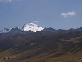
Raju Cutac
Raju Cutac[2] (possibly from Quechua rahu snow, ice, mountain with snow, Ancash Quechua kuta flour; corner, -q a suffix),[3][4][5] Rajo Cutac[6][7] or Rajutuna[8][9][10] (possibly from Quechua tuna slope,[11] "snow peak slope"), is a 5,355-metre-high (17,569 ft)[2][6] mountain in the Cordillera Blanca in the Andes of Peru. It is situated in the Ancash Region, Bolognesi Province, Aquia District. Raju Cutac lies southeast of Challhua and Tuco.[7]
| Raju ancha | |
|---|---|
| Rajutuna | |
 Raju ancha as seen from Lake Conococha | |
| Highest point | |
| Elevation | 5,355 m (17,569 ft) |
| Coordinates | 10°00′34″S 77°10′36″W |
| Geography | |
 Raju ancha Peru | |
| Location | Peru, Ancash Region |
| Parent range | Andes, Cordillera Blanca |
| Climbing | |
| First ascent | 1962[1] |
References
- Neate, Jill (1994). "Peru". Mountaineering in the Andes (PDF). RGS-IBG Expedition Advisory Centre. p. 16. ISBN 0-907649-64-5.
- Alpenvereinskarte 0/3b. Cordillera Blanca Süd (Peru). 1:100 000. Oesterreichischer Alpenverein. 2005. ISBN 3-937530-05-3.
- babylon.com
- Robert Beér, Armando Muyolemaj, Dr. Hernán S. Aguilarpaj, Vocabulario comparativo, quechua ecuatoriano - quechua ancashino - castellano - English, Brighton 2006
- Teofilo Laime Ajacopa (2007). Diccionario Bilingüe: Iskay simipi yuyayk’anch: Quechua – Castellano / Castellano – Quechua (PDF). La Paz, Bolivia.
{{cite book}}: CS1 maint: location missing publisher (link) - Peru 1:100 000, Chiquián (21-i). IGN (Instituto Geográfico Nacional - Perú).
- http://escale.minedu.gob.pe/documents/10156/1367926/ugel_bolognesi.pdf - UGEL map of the Bolognesi Province (Ancash Region)
- Ricker, John (1977). Yuraq Janka: A Guide to the Peruvian Andes. The Mountaineers Books. p. 128.
- "Rajutuna - Peakbagger.com". www.peakbagger.com. Retrieved 2016-07-06.
- Díaz, Felipe (2008–2009). Carta Turística. Cordilleras Blanca, Negra, Huayhuash y Callejón de Huaylas.
- Rimaycuna, Quechua de Huánuco, Diccionario del quechua dell Huallaga con índices castellano e inglés, Serie Lingüistica Peruana No. 48
This article is issued from Wikipedia. The text is licensed under Creative Commons - Attribution - Sharealike. Additional terms may apply for the media files.