Rangiroa (commune)
Rangiroa is a commune of French Polynesia in the archipelago of the Tuamotu Islands. The commune includes four islands: Rangiroa, Tikehau, Mataiva and Makatea.[2] The chef-lieu is the village Tiputa.[2]
Rangiroa | |
|---|---|
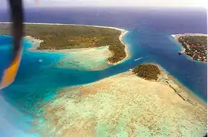 Avatoru Pass, atoll of Rangiroa | |
.gif) Flag | |
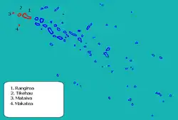 Location (in red) within the Tuamotu Archipelago | |
Location of Rangiroa | |
| Coordinates: 14°57′01″S 147°39′04″W | |
| Country | France |
| Overseas collectivity | French Polynesia |
| Subdivision | Îles Tuamotu-Gambier |
| Government | |
| • Mayor (2021–2026) | Tahuhu Maraeura[1] |
| Area 1 | 139 km2 (54 sq mi) |
| Population (2017) | 3,657 |
| • Density | 26/km2 (68/sq mi) |
| Time zone | UTC−10:00 |
| INSEE/Postal code | 98740 / |
| 1 French Land Register data, which excludes lakes, ponds, glaciers > 1 km2 (0.386 sq mi or 247 acres) and river estuaries. | |
Geography
Commune of Rangiroa
The commune is composed of three atolls and one island:
| Atoll or island | Main village | Population 2017[3] | Area above water(km2) | Lagoon (km2) | Coordinates |
|---|---|---|---|---|---|
| Rangiroa1 | Avatoru | 2,709 | 79 | 1,446 | 15°07′S 147°37′W |
| Tikehau1 | Tuherahera | 560 | 20 | 400 | 15°01′S 148°10′W |
| Mataiva1 | Pahua | 294 | 16 | 25 | 14°53′S 148°40′W |
| Makatea1 | Moumu | 94 | 24 | - | 15°51′S 148°15′W |
| Rangiroa commune | Avatoru | 3,657 | 139 | 1,871 |
Administration
See also
References
- "Répertoire national des élus: les maires". data.gouv.fr, Plateforme ouverte des données publiques françaises (in French). 9 August 2021.
- Décret n°72-407 du 17 mai 1972 portant création de communes dans le territoire de la Polynésie française, Légifrance
- Répartition de la population en Polynésie française en 2017, Institut de la statistique de la Polynésie française
This article is issued from Wikipedia. The text is licensed under Creative Commons - Attribution - Sharealike. Additional terms may apply for the media files.