Rapid intensification
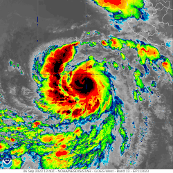
In meteorology, rapid intensification is any process wherein a tropical cyclone intensifies dramatically in a short period of time. The United States National Hurricane Center defines rapid intensification as an increase in the maximum sustained winds of a tropical cyclone of at least 30 knots (35 mph; 55 km/h) in a 24-hour period.[1]
Necessary conditions
External
In order for rapid intensification to occur, several conditions must be in place. Water temperatures must be extremely warm (near or above 30 °C, 86 °F), and water of this temperature must be sufficiently deep that waves do not churn deeper cooler waters up to the surface. Wind shear must be low; when wind shear is high, the convection and circulation in the cyclone will be disrupted.[2] Dry air can also limit the strengthening of tropical cyclones.[3]
Internal
Usually, an anticyclone in the upper layers of the troposphere above the storm must also be present for extremely low surface pressures to develop. This is because air must be converging towards the low pressure at the surface, which the requires the air to rise very rapidly in the eyewall of the storm due to conservation of mass, which in turn also requires a divergence of wind at the top of the troposphere. This process is aided by an upper-level anticyclone which helps efficiently channel this air away from the cyclone.[4] Hot towers have been implicated in tropical cyclone rapid intensification, though they have diagnostically seen varied impacts across basins.[5]
Previous nomenclature and definitions
The United States National Hurricane Center previously defined rapid deepening of a tropical cyclone, when the minimum central pressure decreased by 42 millibars (1.240 inHg) over a 24-hour period.[6] Currently it is defined as an increase in the maximum sustained winds of a tropical cyclone of at least 30 knots (35 mph; 55 km/h) in a 24-hour period.[1]
Forecasting
Probabilistic metrics estimating the likelihood of rapid intensification based on characteristics of the environment surrounding tropical cyclones have been developed and used operationally in storm forecasting.[7][8] Weather models have also shown an improved ability to project rapid intensification events,[9] but continue to face difficulties in accurately depicting their timing and magnitude.[10]
The later half of the 21st century forecasts envision stronger greenhouse gas forcing dominating natural variability which along with warming sea surface temperatures will create more intense hurricanes along the U.S. Atlantic coasts.[11] The same period forecasts for the Gulf of Mexico coasts indicate sufficient wind shear in place to somewhat diminish rapid storm intensification. Atlantic storms, Hurricane Maria and Hurricane Harvey intensified rapidly in 2017.[12]
See also
References
- National Hurricane Center (March 25, 2013). "Glossary of NHC Terms". United States National Oceanic and Atmospheric Administration's National Weather Service. Archived from the original on May 15, 2014. Retrieved April 1, 2014.
- Lam, Linda (October 23, 2015). "Multiple Factors Allowed Hurricane Patricia to Rapidly Intensify". The Weather Channel. Retrieved August 6, 2018.
- Lam, Linda (September 7, 2018). "Based on Hurricane Florence's Location, We Didn't Expect It to Get So Strong So Soon". The Weather Channel. Retrieved September 7, 2018.
- Engle, Diana. "Hurricane Structure and Energetics". Data Discovery Hurricane Science Center. Archived from the original on May 27, 2008. Retrieved October 26, 2008.
- Zhuge, Xiao-Yong; Ming, Jie; Wang, Yuan (October 2015). "Reassessing the Use of Inner-Core Hot Towers to Predict Tropical Cyclone Rapid Intensification*". Weather and Forecasting. 30 (5): 1265–1279. Bibcode:2015WtFor..30.1265Z. doi:10.1175/WAF-D-15-0024.1.
- National Hurricane Center/Tropical Prediction Center (February 7, 2005). "Glossary of NHC/TPC Terms". United States National Oceanic and Atmospheric Administration's National Weather Service. Archived from the original on October 17, 2005. Retrieved April 1, 2014.
- Kaplan, John; DeMaria, Mark; Knaff, John A. (1 February 2010). "A Revised Tropical Cyclone Rapid Intensification Index for the Atlantic and Eastern North Pacific Basins". Weather and Forecasting. 25 (1): 220–241. doi:10.1175/2009WAF2222280.1.
- DeMaria, Mark; Franklin, James L.; Onderlinde, Matthew J.; Kaplan, John (26 May 2021). "Operational Forecasting of Tropical Cyclone Rapid Intensification at the National Hurricane Center". Atmosphere. 12 (6): 683. doi:10.3390/atmos12060683.
- Cangialosi, John P.; Blake, Eric; DeMaria, Mark; Penny, Andrew; Latto, Andrew; Rappaport, Edward; Tallapragada, Vijay (1 October 2020). "Recent Progress in Tropical Cyclone Intensity Forecasting at the National Hurricane Center". Weather and Forecasting. 35 (5): 1913–1922. doi:10.1175/WAF-D-20-0059.1.
- Zhang, Zhan; Wang, Weiguo; Doyle, James D.; Moskaitis, Jonathan; Komaromi, William A.; Heming, Julian; Magnusson, Linus; Cangialosi, John P.; Cowan, Levi; Brennan, Michael; Ma, Suhong; Das, Ananda Kumar; Takuya, Hosomi; Clegg, Peter; Birchard, Thomas; Knaff, John A.; Kaplan, John; Mohapatra, Mrutyunjay; Sharma, Monica; Masaaki, Ikegami; Wu, Liguang; Blake, Eric (March 2023). "A review of recent advances (2018–2021) on tropical cyclone intensity change from operational perspectives, part 1: Dynamical model guidance". Tropical Cyclone Research and Review. 12 (1): 30–49. doi:10.1016/j.tcrr.2023.05.004.
- Ting, Mingfang; P. Kossin, James; J. Camargo, Suzana; Cuihua, Li (24 May 2019). "Past and Future Hurricane Intensity Change along the U.S. East Coast". Scientific Reports. United States National Library of Medicine. 9 (1): 7795. doi:10.1038/s41598-019-44252-w. PMC 6534560. PMID 31127128.
- Shao, Alena (26 September 2022). "A 'Nightmare' for Forecasters: Here's Why Hurricanes Are Getting Stronger, Faster". The New York Times. Retrieved 27 September 2022.
