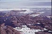
Rauer Islands
The Rauer Islands (68°51′S 77°50′E) are a group of rocky coastal islands which lie between Sorsdal Glacier Tongue and Ranvik Bay, in the southeast part of Prydz Bay. Discovered and roughly charted in February 1935 by a Norwegian expedition under Captain Klarius Mikkelsen (see Caroline Mikkelsen). He named them Rauer, probably after the island lying in Oslofjorden opposite Tønsberg, Norway.

Rauer Islands, 1974, Australian Antarctic Division
See also
![]() This article incorporates public domain material from "Rauer Islands". Geographic Names Information System. United States Geological Survey.
This article incorporates public domain material from "Rauer Islands". Geographic Names Information System. United States Geological Survey.
This article is issued from Wikipedia. The text is licensed under Creative Commons - Attribution - Sharealike. Additional terms may apply for the media files.