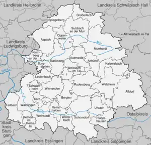
Rems-Murr-Kreis
Rems-Murr is a Landkreis (district) in the middle of Baden-Württemberg, Germany. Neighboring districts are (from north clockwise) Heilbronn, Schwäbisch Hall, Ostalbkreis, Göppingen, Esslingen, the district-free city Stuttgart and the district Ludwigsburg.
Rems-Murr-Kreis | |
|---|---|
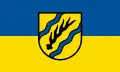 Flag 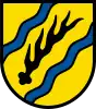 Coat of arms | |
| Country | Germany |
| State | Baden-Württemberg |
| Adm. region | Stuttgart |
| Capital | Waiblingen |
| Area | |
| • Total | 858.14 km2 (331.33 sq mi) |
| Population (31 December 2021)[1] | |
| • Total | 427,316 |
| • Density | 500/km2 (1,300/sq mi) |
| Time zone | UTC+01:00 (CET) |
| • Summer (DST) | UTC+02:00 (CEST) |
| Vehicle registration | WN, BK |
| Website | www |
History
The district was created in 1973 when Waiblingen was merged with most of the district Backnang and a few municipalities from the district Schwäbisch Gmünd.
Geography
The largest part of the district is located in the Swabian-Franconian Forest (Schwäbisch-Fränkischer Wald), of which the Mainhardt Forest forms a part. The two rivers Rems and Murr gave the district its name.
Coat of arms
The coat of arms shows a deer antler in the middle, the symbol of the former state of Württemberg. The two wavy blue lines above and below symbolize the two rivers Murr (in the north) and Rems (in the south) after which the district was named.
Cities and towns
| Cities | Administrative districts | Towns | |
|---|---|---|---|
|
References
- "Bevölkerung nach Nationalität und Geschlecht am 31. Dezember 2021" [Population by nationality and sex as of December 31, 2021] (CSV) (in German). Statistisches Landesamt Baden-Württemberg. June 2022.
External links
- Official website (German)