Renton Hill, Seattle
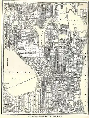
Historically, Renton Hill was a neighborhood of Seattle, Washington, United States. Centered roughly at 18th Avenue and Madison Street, it was roughly the southern part of today's Capitol Hill plus a large adjacent section south of Madison Street.[1][2] It was named after lumberman and merchant Captain William Renton (1818-1891) and replaced the earlier name of Second Hill.[3]

The Renton Hill Community Improvement Club was the city's first community club, organized in 1901 for public improvements such as water, sidewalks, lighting, and beautification.[2] Along with the Capitol Hill Community Club, the club reorganized in 1929 to exclude racial minorities, using a restrictive covenant. This was in reaction to encroaching African American population from the east, Asian from the south, and urban downtown from the west.[4]
The name Renton Hill has fallen into disuse within Seattle, possibly to avoid confusion with a neighborhood in nearby Renton, WA, also named Renton Hill.[5] The portion of Renton Hill north of Madison Street has been subsumed into Capitol Hill while the portion south of it is now commonly referred to as Cherry Hill.

Notes
- Map of the city of Seattle, The New Encyclopedic Atlas & Gazetteer of the World, 1917 Edition, P. F. Collier & Son, p. 234
- David Wilma, Renton Hill residents organize Seattle's first community club on June 18, 1901, HistoryLink, April 1, 2001. Accessed 26 January 2008.
- "Seattle Historical Sites Search Result - Department of Neighborhoods (DON)". web6.seattle.gov. Retrieved 2020-08-23.
- David Wilma, Renton Hill Community Club reorganizes to exclude racial minorities from the neighborhood in 1929, HistoryLink, April 1, 2001. Accessed 26 January 2008.
- "Renton Hill Neighborhood Association – The Official Website of Historic Renton Hill". Retrieved 2020-08-23.