Reporoa Caldera
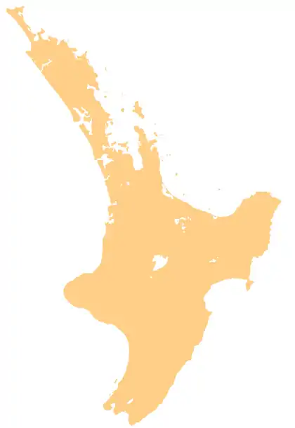
The Reporoa Caldera is a 10 km by 15 km caldera in New Zealand's Taupō Volcanic Zone located in the Taupō-Reporoa Basin. It formed some 280,000 years ago,[1]: 197 in a large eruption that deposited approximately 100 km3 of tephra, forming the Kaingaroa Ignimbrite layer.[2] The ignimbrite sheet extends up to 15 km (9.3 mi) to the east.[3]
| Reporoa Caldera | |
|---|---|
 Reporoa Caldera | |
| Highest point | |
| Elevation | 592 m (1,942 ft) |
| Coordinates | 38°25′00″S 176°20′00″E |
| Dimensions | |
| Length | 15 km (9.3 mi) |
| Width | 10 km (6.2 mi) |
| Geography | |
| Location | Taupō Volcanic Zone, New Zealand |
| Geology | |
| Age of rock | |
| Mountain type | Caldera |
| Last eruption | 1180 (?), 2005 hydrothermal |
In April 2005, a large hydrothermal explosion occurred near a cow paddock within the Taupō-Reporoa Basin, destroying some trees, temporarily blocking a nearby stream and creating a 50-metre crater at 38°32′02″S 176°10′19″E.[4] A similar explosion happened in the area in 1948, and smaller explosions have happened in the years between.[5][4] At the time of the last eruption, it was believed to be within the caldera, but these recent eruptions are not technically within the now known area of the caldera.[1]: 197
Geography
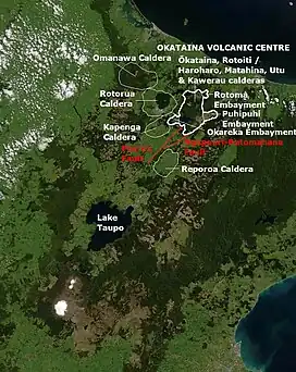
The Reporoa Caldera is located in the northern part of the Taupō-Reporoa Basin, which extends north-east from Lake Taupō in the south to the Waiotapu geothermal area, and whose southern features are distinct from the caldera.[1]: 189 The Waikato River where it leaves Lake Taupō enters the south east corner of the basin and is flanked by geothermal areas developed for power near Wairakei. In the north-west, the basin rises up to the Paeroa Range whose western limit is defined by the Paeroa Fault scarp.[1]: 189 The hills of the eastern basin margin are mostly covered by the Kaingaroa Forest. The Waikato River loops to the north before exiting the basin at its south-west but is always south of the caldera. The basin has been the location of several temporary lakes during its volcanic history. The largest recent one was Lake Reporoa, formed after the Taupō Hatepe eruption about 1,800 years ago.[6]: 109 This lake occupied up to 190 km2 (73 sq mi) of the basin impounding about 2.5 km3 (0.60 cu mi) of water.[6]: 109 In due course its natural dam was breached with a resulting initial flood down the Waikato River and this is known to have been before the later breaching of the ignimbrite dam, also formed by the same eruption, at present outlet of the Lake Taupō.[6]: 109 This larger breach released about 20 km3 (4.8 cu mi) of water,[7]: 327 temporarily flooded some of the area of the former Lake Reporoa.[6]: 109
Geology
It was first recognised as a volcanic caldera in 1994[2]: 1 and later work has defined it as a single major event caldera within the Taupō Rift.[8]: 471 Initially the age was thought to be 0.23 Ma[8]: 471, 473 but is now thought to be about 50,000 years older at 281 ± 21 ka BP.[1]: 197 This age is more consistent with argon–argon dating on the tephra, ignimbrite and samples from the later smaller rhyolite dome eruptions that happened after caldera formation.[1]: 197 One of these was at Deer Hill, which is just to the south of the caldera margin and is dated at 264 ± 4 ka BP. Within the southern area of the caldera proper Pukekahu (263 ± 5 ka BP), and Kairuru (247 ± 2 ka BP) formed.[1]: 197, 203 Gravitational[9]: 1–6 and magnetic[10] studies have been used to define the caldera to being north of the present Waikato River course in the Taupō-Reporoa Basin.[11]: Fig. 1.(a) [1]: 187 A relative gravity low does exist south-west of the river and caldera in the Mihi area and has been called the Mihi volcanic depression, although there is presently no evidence of a related volcanic event.[9]: 4 It is associated with three geothermal fields. These are the active Reporoa geothermal field in the caldera, the Waiotapu geothermal area north of the caldera rim, and the Broadlands thermal area to the south.[11]: Fig. 1.(a & b)
See also
References
- Downs, D.T.; Rowland, J.V.; Wilson, C.J.N.; Rosenberg, M.D.; Leonard, G.S.; Calvert, A.T. (2014). "Evolution of the intra-arc Taupo-Reporoa basin within the Taupo Volcanic Zone of New Zealand". Geosphere. 10 (1): 185–206. doi:10.1130/GES00965.1.
- Nairn, I.A.; Wood, C.P.; Bailey, R.A. (December 1994). "The Reporoa Caldera, Taupo Volcanic Zone: source of the Kaingaroa Ignimbrites". Bulletin of Volcanology. 56 (6): 529–537. Bibcode:1994BVol...56..529N. doi:10.1007/BF00302833. S2CID 128947835.
- Spinks, Karl D. (2005). "Rift Architecture and Caldera Volcanism in the Taupo Volcanic Zone, New Zealand".
- Simpson, Mark P.; Rosenberg, Michael D.; Rae, Andrew J.; Bignall, Greg; Mountain, Bruce W.; Graham, Duncan; Chappell, Debra (2014). "Insight into the 2005 hydrothermal eruption at South Orakonui, Ngatamariki Geothermal Field, New Zealand from calcite microthermometry". Retrieved 16 October 2022.
- Geothermal eruption in New Zealand paddock leaves big crater, The Star, 20 April 2005.
- Manville, V (18 April 2001). James D. L. White; N. R. Riggs (eds.). Sedimentology and history of Lake Reporoa: an ephemeral supra‐ignimbrite lake, Taupo Volcanic Zone, New Zealand in Volcaniclastic sedimentation in lacustrine settings. Wiley. pp. 109–40. ISBN 1444304267.
- Manville, V.; Segschneider, B.; Newton, E.; White, J.D.L.; Houghton, B.F.; Wilson, C.J.N. (2009). "Environmental impact of the 1.8 ka Taupo eruption, New Zealand: Landscape responses to a large-scale explosive rhyolite eruption". Sedimentary Geology. 220 (3–4): 318–336. doi:10.1016/j.sedgeo.2009.04.017.
- S. W. Beresford; J. W. Cole (2000). "Kaingaroa Ignimbrite, Taupo Volcanic Zone, New Zealand: evidence for asymmetric caldera subsidence of the Reporoa Caldera". New Zealand Journal of Geology & Geophysics. 43 (3): 471–481. doi:10.1080/00288306.2000.9514903. S2CID 129243910.
- Soengkono, S. (2012). "Gravity Modelling Of Reporoa Basin, Eastern Taupo Volcanic Zone (TVZ), New Zealand: In Proceedings of the 34th New Zealand Geothermal Workshop, Auckland, New Zealand" (PDF). Retrieved 1 September 2023.
- Soengkono, S.; Hochstein, M.P. (1996). "Interpretation of Magnetic Anomalies over the Reporoa Geothermal Field, Taupo Volcanic Zone, New Zealand: In Proceedings of the 18th New Zealand Geothermal Workshop, Auckland, New Zealand" (PDF). Retrieved 1 September 2023.
- Kaya, E.; O'Sullivan, M.J.; Hochstein, M.P. (2014). "A three dimensional numerical model of the Waiotapu, Waikite and Reporoa geothermal areas, New Zealand". Journal of Volcanology and Geothermal Research. 283: 127–142. doi:10.1016/j.jvolgeores.2014.07.008.