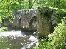
Respryn Bridge
Respryn Bridge is a 15th-century granite and stone bridge over the River Fowey in the parish of Lanhydrock in Cornwall, England. The bridge is a Grade II* listed building.

History
The current Respryn Bridge was built in the 15th century, replacing an earlier bridge over the River Fowey built around 1300.[1][2] The bridge was on the old road from Bodmin to Looe.[2] During the English Civil War, the bridge was used a strategic crossing point between Lanhydrock and Boconnoc, who were on opposing sides in the conflict.[1][3] The bridge was initially held by Roundheads led by Robert Devereux, 3rd Earl of Essex, but was captured by Cavaliers led by Sir Richard Grenville, 1st Baronet in 1644.[4] That same year, King Charles I crossed over the bridge.[1] The bridge carries a through road, with the entrance of Lanhydrock House a short distance away.[5]
In 1969, Respryn Bridge became a Grade II* listed building.[2] In 2006, the bridge was closed for a month after being struck by a lorry, causing thousands of pounds' worth of damage.[3] In 2019, stone bollards were added to the entrance of the bridge, to prevent large vehicles from crossing the bridge.[6]
Architecture
The current Respryn Bridge is constructed from granite and stone, and has five arches.[1][2] Only the central arch is original to the bridge; the other four were added later,[2] and the two arches on the western side are the newest.[1] The bridge is 40 metres (130 feet) long, and has a width of 3 m (9.8 ft).[2] The central arch has a span of 15 ft (4.6 m).[3]
References
- "Respryn Bridge". Cornwall Council. 20 February 2018. Retrieved 29 November 2020.
- "Respryn Bridge". Historic England. Retrieved 29 November 2020.
- Neale, John (March 2013). Exploring the River Fowey. Amberley Publishing. ISBN 9781445623412.
- Gardiner, Samuel Rowson (1894). Volume 2 of History of the Great Civil War, 1642-1649. Longmans, Green. pp. 13–14.
- Polsue, Joseph (1870). A complete parochial history of the county of Cornwall. pp. 7–8.
- "Fears for lives as ambulance gets stuck on bridge following work by Cornwall Council". Cornwall Live. 4 November 2019. Retrieved 29 November 2020.