Richardson Mountains
The Richardson Mountains are a mountain range located west of the mouth of the Mackenzie River in northern Yukon, Canada. They parallel the northernmost part of the boundary between Yukon and Northwest Territories.
| Richardson Mountains | |
|---|---|
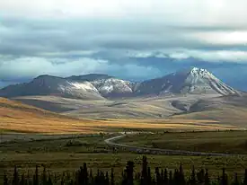 Dempster Highway crossing the Richardson Mountains | |
| Highest point | |
| Peak | Manuel Peak |
| Elevation | 1,722 m (5,650 ft)[1] |
| Prominence | 1,292 m (4,239 ft)[1] |
| Coordinates | 67°59′36″N 136°35′07″W[1] |
| Naming | |
| Etymology | Named for Arctic explorer John Richardson[2] |
| Geography | |
| Country | Canada |
| Territory | Yukon |
| Range coordinates | 68°19′59″N 135°45′09″W[3] |
| Parent range | Brooks Range |
| Topo map | NTS 106L05[3] |
Although some sources[4] consider the Richardson Mountains to be part of the Canadian Rockies, the common northern limit of the Canadian Rockies is the Liard River, which is a long way south. The Richardson Mountains are a sub-range of the Brooks Range which lies mostly in Alaska.[2]
References
- "Manuel Peak". Bivouac.com. Retrieved 2022-10-06.
- "Richardson Mountains". bivouac.com. Retrieved 2016-02-10.
- "Richardson Mountains". Geographical Names Data Base. Natural Resources Canada. Retrieved 2022-10-06.
- "Rocky Mountains | Location, Map, History, & Facts | Britannica".
This article is issued from Wikipedia. The text is licensed under Creative Commons - Attribution - Sharealike. Additional terms may apply for the media files.