Beni River
The Beni River (Spanish: Río Beni) is a river in the north of Bolivia.
| Beni River | |
|---|---|
 | |
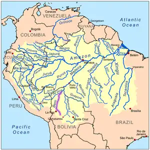
 Map of the Amazon Basin with the Beni River highlighted | |
| Location | |
| Country | Bolivia, Brazil |
| Physical characteristics | |
| Source | |
| • location | La Paz Department, Bolivia |
| Mouth | Madre de Dios River |
• location | near Riberalta, Bolivia–Brazil border |
| Length | 1,100 km (680 mi)[1] |
| Discharge | |
| • location | mouth |
| • average | 2,875 m3/s (101,500 cu ft/s)[2] |
It rises north of La Paz and flows northeast. The Madre de Dios River is where its mouth is at. In the upper portion of its course it flows through highland forest and rainforest, where the rapids of Cachuela Esperanza interrupt the upstream navigability of the river. The middle river runs through dense rainforest where it is joined by the Madidi River and the Tuichi River which flow through Madidi National Park. The Tuichi River joins the Beni River upstream from the town Rurrenabaque. North of Rurrenabaque, the Beni River runs through the Llanos de Moxos also known as the Beni Savanna, which is named from the river. It empties into the larger Madre de Dios at Riberalta.
The Beni River has a number of minor tributaries, including intermittent streams such as the Emero River.[3][4]
In 1947, the CIA received unverified information that suggested there were settlements of escaped Nazis along the Beni and its tributaries.[5]
References
- Ziesler, R.; Ardizzone, G.D. (1979). "Amazon River System". The Inland waters of Latin America. Food and Agriculture Organization of the United Nations. ISBN 92-5-000780-9. Archived from the original on 21 October 2013.
- Molina-Carpio, Jorge; Espinoza, Jhan Carlo; Vauchel, Philippe; Ronchail, Josyane; Gutierrez Caloir, Beatriz; Guyot, Jean-Loup; Noriega, Luis (2017). "Hydroclimatology of the Upper Madeira River basin: Spatio-temporal variability and trends". Hydrological Sciences Journal. 62 (6): 911–927. doi:10.1080/02626667.2016.1267861. S2CID 133578964.
- López, Said Zeitúm (1991). Amazonía boliviana (in Spanish).
- vetenskapsakademien, Kungl Svenska (1945). Kungliga Svenska vetenskapsakademiens handlingar ...
- CIA Information Report: Subject: Heavily Armed Nazi Colony - received 1947, disseminated 1950, declassified 2001.