River Cam (Somerset)
The River Cam is a tributary of the River Yeo in the south of Somerset, England.
| River Cam | |
|---|---|
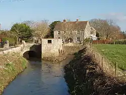 File:The Old Mill on the River Cam, West Camel | |
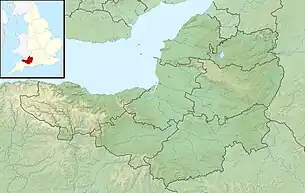 Location of the mouth in Somerset | |
| Location | |
| Country | England |
| State | Somerset |
| District | South Somerset |
| City | North Cadbury, Sparkford, Queen Camel, West Camel |
| Physical characteristics | |
| Source | |
| • location | Yarlington |
| • coordinates | 51°03′38″N 2°27′55″W |
| • elevation | 144 m (472 ft) |
| Mouth | River Yeo |
• location | Yeovilton |
• coordinates | 51°00′06″N 2°38′10″W |
| Length | 17 km (11 mi) |
The Cam rises east of Yarlington (51°00′06″N 2°38′11″W). It flows south west past North Cadbury, Sparkford, Queen Camel and West Camel, and joins the Yeo near Yeovilton (51°00′06″N 2°38′11″W).[1]
Other tributaries include the stream (designated Main River) through Blackford and Compton Pauncefoot and benefited from works in the 1980s to the riverbanks in Blackford to help keep the water moving. Flooding in Blackford is rarer than previously, as a result. This tributary stream has its headwaters in the hills around Blackford and Compton Pauncefoot together with a number of springs. The main waters come from three primary sources: Maperton, Quarry Hill and Sigwells Hill. The first two combine in Blackford around the Crossroads/Hollow and further springs contribute at several points all the way through both villages. The river then travels under the A303 to join the Yarlington headwaters.
The Cam flows onto the Royal Naval Station at Yeovilton where it joins the Yeo, which in turn flows west to the south of Yeovilton and through the town of Ilchester. The river course continues to the west and at Langport becomes the River Parrett.
In 2009 the river burst its banks at West Camel following flash flooding.[2]
The dates the river got to top of the banks in Blackford since 2000 were:
9th May 2023
24th March 2023
4th January 2014
9th February 2009
13th December 2008
Previous floods:
2000
May 1979 - major flooding of church
9th May 2023 flooding was caused by 2 thunderstorms converging and becoming trapped in the vicinity of North Cadbury and creating major flooding from River Cam (& tributaries) of Queen Camel, West Camel, North Cadbury and other villages making the national news. Somerset County Council has started a Section 19 investigation under the Flood & Water Management Act 2010 by holding a series of meetings in June 2023 to gather information. A report will be issued in due course.
The Environment Agency has a monitoring station that gives a clear idea of how the water levels in the River Cam at Weston Bampfylde rises and falls:
0.60m is considered normal
Record High Levels:
2.09m 13.12.08
2.85m 9.5.23
The data shows the river exceeded 1m on 28 occasions between 1998 and 2023:
1m - 1.29m 14 occasions
1.3m - 1.49m 8 occasions
1.5m or more 6 occasions
Total 28
1998 - Oct 2002 = 0
Nov 2002 - Dec 2007 = 3
Jan 2008 - Dec 2012 = 10
Jan 2013 - Dec 2018 = 10
Jan 2019 - Jul 2023 = 5
Total 28
Some years had no events and the maximum in one year was 5 in 2008.
Reference
- "River Cam". Somerset Rivers. Retrieved 2 September 2011.
- "More than 20 rescued from floods". BBC. Retrieved 2 September 2011.
https://www.bbc.co.uk/news/uk-england-somerset-65538995
https://www.somerset.gov.uk/beaches-ports-and-flooding/flood-investigations/