River Tilt
The River Tilt is a tributary of the River Garry in Perth and Kinross, Scotland. It is sourced from the confluence of Tarf Water and the Allt Garbh Buidhe, from which point it flows in a southwesterly direction down the fault-aligned Glen Tilt. In the vicinity of Marble Lodge, it turns gradually to a more southerly course and, at Blair Atholl, enters the left bank of the Garry after being bisected by two islands.[1] The river's elevation drops 270 metres (890 ft) between source and mouth.[2]
| River Tilt | |
|---|---|
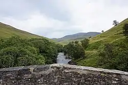 Looking downstream from Gow's Bridge, the first crossing of the river on its journey south | |
| Location | |
| Country | Scotland |
| Physical characteristics | |
| Source | Taft Water and Allt Garbh Buidhe |
| • coordinates | 56.89623962°N 3.67064287°W |
| • elevation | 392 m (1,286 ft) |
| Mouth | River Garry |
• location | Blair Atholl |
• coordinates | 56.761957511°N 3.84488451°W |
• elevation | 122 m (400 ft) |
It is crossed by five bridges on its course, the last one being the Bridge of Tilt, at Blair Atholl village, which carries the traffic of the B8079.[3]
Woodland walks from nearby Blair Castle pass beside the river.[4]
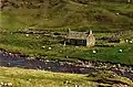 An aerial ropeway spanning the river, approximately halfway along its course, provides a resident easy access to their cottage (2000)
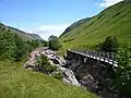 A footbridge across the river
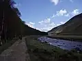
References
- "River Tilt from The Gazetteer for Scotland". www.scottish-places.info. Retrieved 2 July 2022.
- "Find altitude by coordinates - AdvancedConverter". www.advancedconverter.com. Retrieved 2 July 2022.
- "Blair Atholl, Bridge Of Tilt | Canmore". canmore.org.uk. Retrieved 2 July 2022.
- Gifford, John (2007). Perth and Kinross. Yale University Press. p. 87. ISBN 9780300109221.
This article is issued from Wikipedia. The text is licensed under Creative Commons - Attribution - Sharealike. Additional terms may apply for the media files.