Valserine
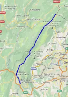
The river Valserine (French pronunciation: [valsəʁin]) is a tributary of the Rhône that flows for 47.6 kilometres (29.6 mi) from the Col de la Faucille in the Jura Mountains to its confluence with the Rhône at Bellegarde-sur-Valserine.[1] The Valserine Valley has great charm; it includes the Pont des Pierres that spans the river between Montanges and Mulaz (in the commune of Confort),[2][3] as well as the Pertes de la Valserine just north of Bellegarde-sur-Valserine, a canyon in which during the dry season the Valserine runs underground.
| Valserine | |
|---|---|
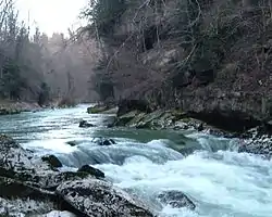 The Valserine at Bellegarde-sur-Valserine | |
 | |
| Location | |
| Country | France |
| Physical characteristics | |
| Source | |
| • location | Jura Mountains |
| Mouth | Rhône |
• location | Bellegarde-sur-Valserine |
• coordinates | 46.1062°N 5.8292°E |
| Length | 48 km (30 mi) |
| Basin features | |
| Progression | Rhône→ Mediterranean Sea |
As the river flows through the village of Mijoux, it marks the border between Ain (a department in the Auvergne-Rhône-Alpes region) and Jura (in Bourgogne-Franche-Comté).[4][5]
References
- Sandre. "Fiche cours d'eau - La Valserine (V1010500)".
- Valserine, www.planetware.com. Accessed 31 March 2008
- Pont des Pierres at Structurae
- Monts Jura, www.frenchaccommodation.co.uk Accessed 31 March 2008
- map
Wikimedia Commons has media related to Valserine.
Further reading
- Parks, Reserves, and Other Protected Areas in France (Haut-Jura and Pont-des-Pierres)
- Natura 2000 : Fiche du site FR8201648 (GALERIE A CHAUVES-SOURIS DU PONT DES PIERRES) (French)
This article is issued from Wikipedia. The text is licensed under Creative Commons - Attribution - Sharealike. Additional terms may apply for the media files.