Rivière-Ojima
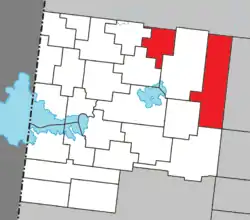
Rivière-Ojima is an unorganized territory in the Abitibi-Témiscamingue region of Quebec, Canada. It consists of two non-contiguous areas in the Abitibi-Ouest Regional County Municipality, separated by the municipality of Authier-Nord. The hamlets of Languedoc (48°48′26″N 78°41′48″W) and Saint-Eugène-de-Chazel (48°57′06″N 78°58′38″W) are located within its boundaries.
Rivière-Ojima | |
|---|---|
 Location within Abitibi-Ouest RCM | |
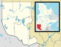
 Rivière-Ojima Location in western Quebec | |
| Coordinates: 48°50′N 78°42′W[1] | |
| Country | Canada |
| Province | Quebec |
| Region | Abitibi-Témiscamingue |
| RCM | Abitibi-Ouest |
| Constituted | January 1, 1986 |
| Government | |
| • Federal riding | Abitibi—Témiscamingue |
| • Prov. riding | Abitibi-Ouest |
| Area | |
| • Total | 359.59 km2 (138.84 sq mi) |
| • Land | 354.47 km2 (136.86 sq mi) |
| Population (2021)[3] | |
| • Total | 60 |
| • Density | 0.2/km2 (0.5/sq mi) |
| • Pop (2016-21) | |
| • Dwellings | 39 |
| Time zone | UTC−05:00 (EST) |
| • Summer (DST) | UTC−04:00 (EDT) |
| Highways | No major routes |
Founded in 1949, Languedoc is the youngest rural population centre in the Abitibi region and named after the Languedoc Regiment, which arrived in New France in 1755 from Languedoc in southern France. The Parish of Saint-Etienne-de-Languedoc was formed in 1952.[4]
Demographics
Population
Canada census – Rivière-Ojima community profile
| 2021 | 2016 | 2011 | |
|---|---|---|---|
| Population | 60 (-30.2% from 2016) | 86 (-17.3% from 2011) | 104 (-17.5% from 2006) |
| Land area | 354.47 km2 (136.86 sq mi) | 356.56 km2 (137.67 sq mi) | 356.04 km2 (137.47 sq mi) |
| Population density | 0.2/km2 (0.52/sq mi) | 0.2/km2 (0.52/sq mi) | 0.3/km2 (0.78/sq mi) |
| Median age | 57.6 (M: 57.6, F: 58.0) | 54.5 (M: 54.5, F: 54.5) | 50.6 (M: 54.5, F: 48.5) |
| Private dwellings | 39 (total) | 53 (total) | 51 (total) |
| Median household income | $.N/A | $.N/A | $.N/A |
|
| ||||||||||||||||||||||||||||||
| Source: Statistics Canada[10] | |||||||||||||||||||||||||||||||
Language
| Canada Census Mother Tongue - Rivière-Ojima, Quebec[10] | ||||||||||||||||||
|---|---|---|---|---|---|---|---|---|---|---|---|---|---|---|---|---|---|---|
| Census | Total | French |
English |
French & English |
Other | |||||||||||||
| Year | Responses | Count | Trend | Pop % | Count | Trend | Pop % | Count | Trend | Pop % | Count | Trend | Pop % | |||||
2011 |
100 |
100 | 100.00% | 0 | 0.00% | 0 | 0.00% | 0 | 0.00% | |||||||||
2006 |
120 |
120 | 100.00% | 0 | 0.00% | 0 | 0.00% | 0 | 0.00% | |||||||||
2001 |
115 |
115 | 100.00% | 0 | 0.00% | 0 | 0.00% | 0 | 0.00% | |||||||||
1996 |
120 |
120 | n/a | 100.00% | 0 | n/a | 0.00% | 0 | n/a | 0.00% | 0 | n/a | 0.00% | |||||
See also
References
- "Reference number 149739 in Banque de noms de lieux du Québec". toponymie.gouv.qc.ca (in French). Commission de toponymie du Québec.
- "Geographic code 87904 in the official Répertoire des municipalités". www.mamh.gouv.qc.ca (in French). Ministère des Affaires municipales et de l'Habitation.
- "Profile table, Census Profile, 2021 Census of Population - Rivière-Ojima, Unorganized (NO) [Census subdivision], Quebec". 9 February 2022.
- "Languedoc (Village)" (in French). Commission de toponymie du Québec. Retrieved 2008-10-01.
- "2021 Community Profiles". 2021 Canadian Census. Statistics Canada. February 4, 2022. Retrieved 2022-04-27.
- "2016 Community Profiles". 2016 Canadian Census. Statistics Canada. August 12, 2021. Retrieved 2023-07-14.
- "2011 Community Profiles". 2011 Canadian Census. Statistics Canada. March 21, 2019. Retrieved 2014-03-30.
- "2006 Community Profiles". 2006 Canadian Census. Statistics Canada. August 20, 2019.
- "2001 Community Profiles". 2001 Canadian Census. Statistics Canada. July 18, 2021.
- 1996, 2001, 2006, 2011, 2016, 2021 census
External links
Wikimedia Commons has media related to Rivière-Ojima.
- Languedoc (TNO Rivière-Ojima) - MRC d'Abitibi-Ouest
- St-Eugene-de-Chazel (TNO Rivière-Ojima) - MRC d'Abitibi-Ouest
This article is issued from Wikipedia. The text is licensed under Creative Commons - Attribution - Sharealike. Additional terms may apply for the media files.