Rivière à la Loutre (Témiscamingue)
The rivière à la Loutre (English: Otter River) is a tributary of the upper part of the Ottawa River. Rivière à la Loutre crosses the territory of the municipalities of Fugèreville and Saint-Bruno-de-Guigues, in the regional county municipality (MRC) of Témiscamingue, in Abitibi-Témiscamingue, in Quebec, in Canada.
| Rivière à la Loutre | |
|---|---|
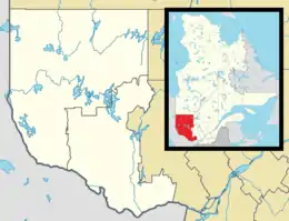 Location of mouth.  Rivière à la Loutre (Témiscamingue) (Quebec)  Rivière à la Loutre (Témiscamingue) (Canada) | |
| Location | |
| Country | Canada |
| Province | Quebec |
| Region | Abitibi-Témiscamingue |
| Regional County Municipality | Témiscamingue Regional County Municipality |
| Physical characteristics | |
| Source | Lac de l'Argentier (ex-Lake d'Argent) |
| • location | Fugèreville |
| • coordinates | 47°17′00″N 79°08′05″W |
| • elevation | 292 m (958 ft) |
| Mouth | Lake Timiskaming |
• location | Saint-Bruno-de-Guigues |
• coordinates | 47°31′12″N 79°28′58″W |
• elevation | 172 m (564 ft) |
| Length | 57.4 km (35.7 mi) |
| Basin features | |
| Progression | Lake Timiskaming— Ottawa River→ Saint Lawrence River→ Gulf of Saint Lawrence |
Geography

The neighboring watersheds of the Rivière à la Loutre are:
- north side: Lake Timiskaming;
- east side: Laverlochère River, Cameron stream;
- south side: Lac Témiscamingue, Ottawa River, l'Africain stream;
- west side: lac Témiscamingue.
The main tributary of the Rivière à la Loutre is the Laverlochère River (coming from the east).
Lac d'Argent (formerly Lac d'Argent) (altitude: 292 m (958 ft)) constitutes the head lake of Rivière à la Loutre. ”It is located west of Lac Brisebois and west of the village of Ville-Marie.
From Lac d'Argent, the Rivière à la Loutre flows on 8.1 km (5.0 mi) west, then north, to the south shore of Lac des Douze, which the current crosses on 2.1 km (1.3 mi) to the north; then 4.8 km (3.0 mi) north to the mouth of the Laverdochère river (coming from the north); then, 21.2 km (13.2 mi) (or 12.9 km (8.0 mi) in a direct line) westward, forming several small coils, until the outlet of a stream coming from the south; then 12.8 km (8.0 mi) (or 9.0 km (5.6 mi) in a direct line) northward, forming several coils, to the discharge (coming from the north) of Deep Lake (altitude: 222 m (728 ft)); then 8.4 km (5.2 mi) west and north, up to its mouth.
Along its course, the Rivière à la Loutre collects several agricultural streams and passing just south of the village of Fugèreville. Its mouth is located at 229 m (751 ft) of altitude in the sixth rang of Fugèreville. The river flows into Paulson Bay, on the east shore of Lake Timiskaming, on the Ottawa River.
Toponymy
The toponym Rivière à la Loutre was made official on December 5, 1968, at the Commission de toponymie du Québec.[1]