Rivière du Loup (Bas-Saint-Laurent)
The Rivière du Loup is a river in eastern Quebec, Canada, which empties on the south shore of Saint Lawrence River at the city of Rivière-du-Loup, which is part of the regional county municipality (RCM) Rivière-du-Loup, in the administrative region of Bas-Saint-Laurent.
| Rivière du Loup (English: Wolf River) | |
|---|---|
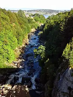 Gorge of the Riviere du Loup at the city of Rivière-du-Loup | |
| Location | |
| Country | Canada |
| Province | Quebec |
| Physical characteristics | |
| Source | Saint-Pierre Lake |
| • elevation | 479 m (1,572 ft) |
| Mouth | Saint Lawrence River |
• location | Rivière-du-Loup |
• coordinates | 47°51′07″N 69°33′16″W |
• elevation | 0 ft (0 m) |
| Length | 101.3 km (62.9 mi) |
There is a hydroelectric plant on the river near the city.
Geography
The Rivière du Loup (English: "river of the Wolf") has its source in Saint-Pierre Lake (Lac Saint-Pierre) in the geographic township of Painchaud in the Kamouraska Regional County Municipality, which is in the Notre Dame Mountains and the Zone d'exploitation contrôlée (English: Controlled Harvesting Zone) of Zec Chapais.[1] This lake is located 36.5 km (23 miles) east of the southeast coast of the Gulf of St. Lawrence, 20 km (12 miles) southeast of the village center of Saint-Bruno-of-Kamouraska and 20 km (12 miles) south-west of the village center of Saint-Athanase.
The Rivière du Loup flows to the north over 101.3 kilometers (63 miles), coursing through the regional county municipalities of:
- MRC Kamouraska: municipalities (starting from the upstream)
- MRC Rivière-du-Loup: municipalities (starting from the upstream)
At its mouth, the Rivière du Loup pours over a long ledge (at low tide) in the "Cayes to Carrier Bay" which is bordered on the north side by the Pointe-de-Rivière-du-Loup. From Malin Rock, this edge advances towards the southwest in the St. Lawrence River over a length of 1.6 km (1 mile), including the end where a marina is fitted.
The river's mouth is located in front of the Île aux Lièvres (English: Island of Hare) and the Île Blanche (English: White Island), located 10 km (6 miles) offshore and part of the municipality of Saint-André-de-Kamouraska. The Channel "Pot à l'Eau-de-Vie" (English: "Pot of stream water") separates the island and the southeast coast of St. Lawrence River. The Estuary Islands Wildlife Reserve (Réserve faunique des Îles de l'Estuaire) was built on a set of islands between the Île aux Lièvres and the channel Pot à l'Eau-de-Vie.
Toponymy
The river's name means Wolf River in French and may have come from a native tribe known as "Les Loups" or from the many seals, known in French as loup marin, once found at the river's mouth.[1]
References
- "Reference number 66892 in Banque de noms de lieux du Québec". toponymie.gouv.qc.ca (in French). Commission de toponymie du Québec.