Roads and expressways in Chicago
Roads and expressways in Chicago summarizes the main thoroughfares and the numbering system used in Chicago and its surrounding suburbs.
Street layout
Chicago's streets were laid out in a grid that grew from the city's original townsite plan platted by James Thompson. Streets following the Public Land Survey System section lines later became arterial streets in outlying sections. As new additions to the city were platted, city ordinance required them to be laid out with eight streets to the mile in one direction and 16 in the other direction. A scattering of diagonal streets, many of them originally Native American trails, also cross the city. Many additional diagonal streets were recommended in the Plan of Chicago, but only the extension of Ogden Avenue was ever constructed. In the 1950s and 1960s, a network of superhighways was built radiating from the city center.[1]
As the city grew and annexed adjacent towns, problems arose with duplicate street names and a confusing numbering system based on the Chicago River. On June 22, 1908, the city council adopted a system proposed by Edward P. Brennan;[2] amended June 21, 1909. The changes were effective September 1, 1909 for most of the city.[3]
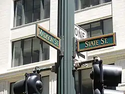
Addresses in Chicago and some suburbs are numbered outward from baselines at State Street, which runs north and south, and Madison Street, which runs east and west.
A book was published in 1909 by The Chicago Directory Company indexing the old and new street numbers for most of Chicago. This volume is available online in PDF format indexed by initial letter, Plan of Re-Numbering, City of Chicago, August 1909.[3] The opening text of the book says: EXPLANATORY
The new house numbering plan passed by the City Council June 22, 1908, to be in force and effect September 1, 1909, makes Madison Street from Lake Michigan to the city limits on the west the base line for numbering all north and south streets and streets running in northerly or southerly direction. For east and west streets and streets running in a generally east and west direction the base line is State Street from the southern city boundary line to North Avenue, thence extended by an imaginary line through Lincoln Park and Lake Michigan.
The downtown area did not conform to this system until April 1, 1911, per an amendment to the law on June 20, 1910. Downtown was defined as Lake Michigan on the east, Roosevelt Road (Twelfth Street) on the south, and the Chicago River on the north and west. The addition to cover downtown was published, and is also on line as a pdf indexed by downtown street name.[4]
This additional paragraph explained the downtown changes:
The 1909 address change did not affect downtown Chicago, between the river and Roosevelt Road, the river and Lake Michigan. The ordinance was amended June 20, 1910 to include the downtown area. The new addresses for the “loop” went into use on April 1, 1911.
Chicago house numbers are generally assigned at the rate of 800 to a mile. The only exceptions are from Madison to 31st Street, just south of downtown. Roosevelt Road (previously Twelfth St) is one mile south of Madison with 1200 addresses to the mile, Cermak Road (previously 22nd Street) is two miles south of Madison with 1000 addresses to the mile, and 31st Street (3100 S) is three miles south of Madison with 900 addresses to the mile.[3] South of 31st Street, the pattern of 800 to the mile resumes, with 39th Street the next major street, 47th after that, and so on. Individual house numbers are normally assigned at the rate of one per 20 feet of frontage. Thus the last two digits of house numbers generally go only as high as 67 before the next block number is reached. Higher house numbers are found on diagonal streets and have sometimes been assigned by request.
The blocks are normally counted out by "hundreds," so that Chicagoans routinely give directions by saying things such as "about twelve hundred north on Western" or "around twenty-four hundred west on Division" (which both describe the intersection of Western Avenue (2400 W) and Division Street (1200 N)).
South of Madison Street most of the east–west streets are simply numbered. The street numbering is aligned with the house numbering, so that 95th Street is exactly 9500 South. "Half-block" east–west thoroughfares in this area are numbered and called places; 95th Place would lie just south of and parallel to 95th Street, and just north of 96th Street.
Every four blocks (half-mile) is a major secondary street. For example, Division Street (1200 N) is less important than either Chicago Avenue (800 N) or North Avenue (1600 N), but is still a major thoroughfare. However, this is not always the case; for example, on the city's Far North Side, Peterson Avenue (6000 N) is a more heavily trafficked street than Bryn Mawr Avenue (5600 N), which sits exactly at the 7-mile marker. U.S. Route 14 is routed along Peterson between Clark Street at 1600 W and Cicero Avenue at 4800 W, whereas Bryn Mawr is discontinuous, split into two segments in this part of the city by Rosehill Cemetery between Damen and Western Avenues.
Even-numbered addresses are found on the north and west sides of a street, and odd numbers are found on the south and east sides, irrespective of the streets' position relative to the corner of State and Madison.
Diagonals, even if they were to run exactly 45 degrees off of the cardinal directions, are numbered as if they were north–south or east–west streets. Examples are North Lincoln Avenue and Ogden Avenue, which bends at Madison and changes from North Ogden to West Ogden.
The northernmost street in Chicago is Juneway Terrace (7800 N), just north of Howard Street. The southern boundary is 138th Street. The eastern boundary of Chicago is Avenue A/State Line Road (4100 E) along and south of 106th Street, and the furthest west the city extends is in the portion of O'Hare International Airport that lies in DuPage County, just east of Elmhurst/York Road.
Street names
While all north–south streets within city limits are named, rather than numbered, smaller streets in some areas are named in groups all starting with the same letter; thus, when traveling westward on a Chicago street, starting just past Pulaski Road (4000 W), one will cross a mile-long stretch of streets which have names starting with the letter K (From east to west: Keystone (North Side)/Komensky (South Side), Karlov, Kedvale, Keeler, Kildare, Kolin, Kostner, Kenneth, Kilbourn, Kolmar, Kenton, Knox, Kilpatrick, Keating), giving rise to the expression "K-town". These streets are found approximately in the 11th mile west of the Indiana state line, and so begin with the 11th letter of the alphabet. A mile later, just past Cicero (4800 W), the starting letter changes to L, and mile by mile the letters progress up to P. Additionally, for most of the first mile west of the Illinois/Indiana state line, streets are lettered from Avenue A at the state line (4100 E) to Avenue O (3430 E), forming the A group. The areas that might otherwise be the B through J groups are the older parts of the city where street names were already well established before this system was developed (although some small groups of streets seem to have been given names intended to conform to the system), and the Q group (8800 to 9600 W) would fall west of the city, as the only land in Chicago west of 8800 West is O'Hare International Airport, undeveloped forest preserve, and a small strip of land connecting O'Hare to the rest of the city and containing only Foster Avenue.
Suburbs
Some suburbs number their east–west streets in a continuation of the Chicago pattern, and even more number their houses according to the Chicago grid. A few suburbs also number their north–south avenues according to the Chicago grid, although such numbering vanished from Chicago itself long ago (the alphabetical naming scheme was devised to help eliminate it). For example, the 54th/Cermak terminus of the Pink Line is located near the intersection of 54th Avenue and Cermak Road (22nd Street) in Cicero. This is 54 blocks west of State Street in Chicago. A minor street 54+1⁄2 blocks west of State Street would be called 54th Court (in reality, that is Lotus Avenue in Chicago).
This pattern continues as far west as Plainfield, which has a 252nd Avenue, as far north as Skokie at Central Street (10100 North),[5] and as far south as the southern edge of Will County. Suburbs that follow the Chicago numbering system include Niles, Rosemont, Morton Grove, Skokie, Lincolnwood, Franklin Park, River Grove, Evergreen Park, Oak Lawn, Oak Forest, Matteson, Channahon, unincorporated parts of Des Plaines, Glenview, and other parts of Cook County, Will, and DuPage Counties. Other suburbs, including Evanston, Park Ridge, Oak Park, Glenview and Wilmette use their own numbering systems. The six "collar" counties (DuPage, Kane, Kendall, Lake, McHenry, and Will) use State and Madison as a base line. For example, 32W000 in DuPage County is 32 miles west of State Street, 38000 in Lake County would be 38 miles north of Madison Street, and is normally used without the direction letter. In these counties, unlike Chicago, numbering is 1,000 numbers to the mile, so in DuPage County 32+1⁄2 miles west is 32W500.
Some Chicago suburbs in adjoining Northwest Indiana also use the Chicago numbering system. These include East Chicago, Whiting, and Hammond. There are even examples further south in Lake County in Dyer and Schererville such as 205th Place through 215th Street (these examples coordinate with the Chicago grid, not the Gary street system). Other municipalities, such as Highland, and Griffith are based on the Gary, Indiana numbering system, beginning with 5th Avenue in Gary and increasing numerically as one travels southward. Examples in Scheider in the far south of Lake County, Indiana go as far down as 244th Avenue.
The aforementioned pattern also occurs in Waukegan, Illinois, with Washington Street being the baseline between north and south. Nearby municipalities such as Gurnee, Park City, and North Chicago continue with the Waukegan numbering pattern, while rural areas in Lake County, Illinois follow the Chicago grid.
Grid
Mile roads
| East-West Streets | North-South Streets | |||||
|---|---|---|---|---|---|---|
| Mile | Address number | Street name | Route designation | Address number | Street name | Route designation |
| 31 | 31000 W | 248th Avenue | ||||
| 30 | 30000 W | IL 59 (240th Avenue) | ||||
| 29 | 29000 W | Ogden Avenue; Rickert Drive; Book Road (232nd Avenue) | ||||
| 28 | 28000 W | Plainfield–Naperville Road (224th Avenue) | ||||
| 27 | 27000 W | Barrington Road; Shaffner Road; Washington Street; Modaff Road (216th Avenue) | ||||
| 26 | ||||||
| 25 | 20300 W | Hough Street | ||||
| 24 | 20000 W | Summit Street | ||||
| 23 | 18000 W | Roselle Road | ||||
| 22 | 16600 W | IL 53; Meacham Road (176th Avenue) | ||||
| 21 | 16200 W | Rohlwing Road; Columbine Avenue; Woodward Avenue; Smith Road (168th Avenue) | ||||
| 20 | 15800 W | Main Street; Brookbank Road; Dunham Road; Lemont Road (160th Avenue) | ||||
| 19 | 15000 W | Prospect Road; Fairview Avenue (152nd Avenue) | ||||
| 18 | 14200 W | Tonne Road; Ardmore Avenue; Cass Avenue (144th Avenue) | ||||
| 17 | 13400 W | Busse Road; Kingery Highway; Clarendon Hills Road; Parker Road (136th Avenue) | ||||
| 16 | 12800 W | Elmhurst Road; York Road; Madison Street; Bell Road (128th Avenue) | ||||
| 15 | 12000 W | Mt. Prospect Road; County Line Road; Will–Cook Road (120th Avenue) | ||||
| 14 | 11200 W | Wolf Road (112th Avenue) | ||||
| 13+1⁄2 | 10800 W | 49th Avenue; Gilbert Avenue; Willow Springs Road (108th Avenue) | ||||
| 13 | 10400 W | Mannheim Road; Brainard Avenue; Flavin Road; Willow Springs Road (104th Avenue) | ||||
| 12+1⁄2 | 10000 N | Old Orchard Road | 10000 W | 33rd Avenue; Scott Street; Eastern Avenue; West Avenue (100th Avenue) | ||
| 12 | 9600 N | Golf Road | 9600 W | La Grange Road; Rose Street; 25th Avenue; Kenman Avenue (96th Avenue) | ||
| 11+1⁄2 | 9200 N | Church Street | 9200 W | 17th Avenue; Maple Avenue; Kean Avenue (92nd Avenue) | ||
| 11 | 8800 N | Dempster Street | 8800 W | 9th Avenue; East River Road; Cork Avenue (88th Avenue) | ||
| 10+1⁄2 | 8400 N | Main Street | 8400 W | 1st Avenue; Cumberland Avenue (84th Avenue) | ||
| 10 | 8000 N | Oakton Steet | 8000 W | Pacific Avenue; Roberts Road (80th Avenue) | ||
| 9+1⁄2 | 7600 N | Howard Street | 7600 W | Oriole Avenue; Lathrop Avenue (76th Avenue) | ||
| 9 | 7200 N | Touhy Avenue | 7200 W | Harlem Avenue (72nd Avenue) | ||
| 8+1⁄2 | 6800 N | Pratt Boulevard | 6800 W | Oak Park Avenue; Justamere Road (68th Avenue) | ||
| 8 | 6400 N | Devon Avenue | 6400 W | Narragansett Avenue; Ridgeland Avenue; Nagle Avenue (64th Avenue) | ||
| 7+1⁄2 | 6000 N | Peterson Avenue | 6000 W | Austin Avenue (60th Avenue) | ||
| 7 | 5600 N | Bryn Mawr Avenue | 5600 W | Central Avenue (56th Avenue) | ||
| 6+1⁄2 | 5200 N | Foster Avenue | 5200 W | Laramie Avenue (52nd Avenue) | ||
| 6 | 4800 N | Lawrence Avenue | 4800 W | Cicero Avenue; Skokie Boulevard (48th Avenue) | ||
| 5+1⁄2 | 4400 N | Montrose Avenue | 4400 W | Kostner Avenue (44th Avenue) | ||
| 5 | 4000 N | Irving Park Road | 4000 W | Pulaski Road; Crawford Avenue (40th Avenue) | ||
| 4+1⁄2 | 3600 N | Addison Street | 3600 W | Central Park Avenue (36th Avenue) | ||
| 4 | 3200 N | Belmont Avenue | 3200 W | Kedzie Avenue (32nd Avenue) | ||
| 3+1⁄2 | 2800 N | Diversey Parkway (Diversey Parkway) | 2800 W | California Avenue (28th Avenue) | ||
| 3 | 2400 N | Fullerton Avenue (Fullerton Parkway) | 2400 W | Western Avenue (24th Avenue) | ||
| 2+1⁄2 | 2000 N | Armitage Avenue (Chicago) | 2000 W | Damen Avenue (20th Avenue) | ||
| 2 | 1600 N | North Avenue (North Boulevard) | 1600 W | Ashland Avenue (16th Avenue) | ||
| 1+1⁄2 | 1200 N | Division Street | 1200 W | Racine Avenue (12th Avenue) | ||
| 1 | 800 N | Chicago Avenue | 800 W | Halsted Street (8th Avenue) | ||
| 1⁄2 | 400 N | Kinzie Street | 400 W | Sedgwick Street; Sheridan Road (4th Avenue) | ||
| 0 | 0 N/S | Madison Street | 0 E/W | State Street (Middle Avenue) | ||
| 1⁄2 | 600 S | Harrison Street (6th Street) | 400 E | Martin Luther King Jr. Drive | ||
| 1 | 1200 S | Roosevelt Road (12th Street) | 800 E | Cottage Grove Avenue | ||
| 1+1⁄2 | 1600 S | 16th Street | 1200 E | Woodlawn Avenue | ||
| 2 | 2200 S | Cermak Road (22nd Street) | 1600 E | Stony Island Avenue | ||
| 2+1⁄2 | 2600 S | 26th Street | 2000 E | Jeffery Boulevard | ||
| 3 | 3100 S | 31st Street (Oak Brook Road) | 2400 E | Yates Boulevard | ||
| 3+1⁄2 | 3500 S | 35th Street | 2800 E | Burnham Avenue | ||
| 4 | 3900 S | Pershing Road (39th Street) | 3200 E | Brandon Avenue | ||
| 4+1⁄2 | 4300 S | 43rd Street (Muddy Waters Drive; Shields Avenue) | 3600 E | Avenue L | ||
| 5 | 4700 S | 47th Street (Chicago Avenue) | 4000 E | Avenue C | ||
| 5+1⁄2 | 5100 S | 51st Street (East Hyde Park Boulevard) | ||||
| 6 | 5500 S | Garfield Boulevard (55th Street) | ||||
| 6+1⁄2 | 5900 S | 59th Street | ||||
| 7 | 6300 S | 63rd Street | ||||
| 7+1⁄2 | 6700 S | Marquette Road (67th Street) | ||||
| 8 | 7100 S | 71st Street | ||||
| 8+1⁄2 | 7500 S | 75th Street | ||||
| 9 | 7900 S | 79th Street | ||||
| 9+1⁄2 | 8300 S | 83rd Street (German Church Road; Montgomery Road) | ||||
| 10 | 8700 S | 87th Street (Oldfield Road) | ||||
| 10+1⁄2 | 9100 S | 91st Street | ||||
| 11 | 9500 S | 95th Street | ||||
| 11+1⁄2 | 9900 S | 99th Street | ||||
| 12 | 10300 S | 103rd Street | ||||
| 12+1⁄2 | 10700 S | 107th Street | ||||
| 13 | 11100 S | Calumet Sag Road; Hassert Boulevard (111th Street) | ||||
| 13+1⁄2 | 11500 S | 115th Street | ||||
| 14 | 11900 S | 119th Street | ||||
| 14+1⁄2 | 12300 S | 123rd Street (McCarthy Road) | ||||
| 15 | 12700 S | 127th Street | ||||
| 15+1⁄2 | 13100 S | 131st Street | ||||
| 16 | 13500 S | 135th Street (Romeo Road) | ||||
| 16+1⁄2 | 13900 S | 139th Street | ||||
| 17 | 14300 S | 143rd Street | ||||
| 17+1⁄2 | 14700 S | Sibley Boulevard (147th Street) | ||||
| 18 | 15100 S | 151st Street | ||||
| 18+1⁄2 | 15500 S | 155th Street (158th Street) | ||||
| 19 | 15900 S | 159th Street (162nd Street) | ||||
| 19+1⁄2 | 16300 S | 163rd Street | ||||
| 20 | 16700 S | 167th Street (Division Street) | ||||
| 20+1⁄2 | 17100 S | 171st Street | ||||
| 21 | 17500 S | 175th Street | ||||
| 21+1⁄2 | 17900 S | 179th Street (Cambridge Drive) | ||||
| 22 | 18300 S | 183rd Street (Orland Parkway) | ||||
| 22+1⁄2 | 18700 S | 187th Street | ||||
| 23 | 19100 S | Flossmoor Road; Glenwood–Lansing Road (191st Street) | ||||
| 23+1⁄2 | 19500 S | 195th Street | ||||
| 24 | 19900 S | Vollmer Road (199th Street) | ||||
| 24+1⁄2 | 20300 S | Joe Orr Road (203rd Street) | ||||
| 25 | 20700 S | 207th Street (10th Street) | ||||
| 25+1⁄2 | 21100 S | Lincoln Highway; 14th Street (211th Street) | ||||
| 26 | 21500 S | 215th Street | ||||
| 26+1⁄2 | 21900 S | 26th Street (219th Street) | ||||
| 27 | 22300 S | 30th Street; Laraway Road; Sauk Trail (223rd Street) | ||||
| 28 | 23100 S | Steger Road (231st Street) | ||||
(No part of Golf Road, Dempster Street, Oakton Street, Wolf Road, LaGrange Road or 143rd Street to 231st Street actually lies within the boundaries of Chicago. These streets are included for reference, since they are a continuation of the Chicago mile street pattern into the suburbs.)[6]
Downtown
The density of main streets in downtown Chicago is greater than in the rest of the city, with some at half-block spacing (just 50 address numbers or one-sixteenth mile from the next parallel street), or block spacing between main streets, unlike the rest of the city where the main streets are spaced at half-mile and mile intervals:
- North/south:
- Canal Street (500 W)
- Wacker Drive (400 W)
- Franklin Street (300 W)
- Wells Street (200 W)
- LaSalle Street (150 W)
- Clark Street (100 W)
- Dearborn Street (36 W)
- State Street (0 E/W)
- Wabash Avenue (44 E)
- Michigan Avenue (100 E)
- Columbus Drive (300 E)
- McClurg Court (400 E)
- East/west:
- Oak Street (1000 N)
- Chicago Avenue (800 N)
- Huron Street (700 N)
- Ohio Street (600 N)
- Grand Avenue (530 N)
- Illinois Street (500 N)
- Hubbard Street (430 N)
- Kinzie Street (400 N)
- Wacker Drive (300 N)
- Lake Street (200 N)
- Randolph Street (150 N)
- Washington Street (100 N)
- Madison Street (0 N/S)
- Monroe Street (100 S)
- Adams Street (200 S)
- Jackson Boulevard (300 S)
- Van Buren Street (400 S)
- Ida B. Wells Drive/Congress Parkway (500 S)
- Harrison Street (600 S)
- Polk Street (800 S)
Secondary streets
- East/west:
- 10000 N – (Old Orchard Road)
- 9200 N – (Church Street)
- 8400 N – (Main Street)
- 7600 N – Howard Street
- 6800 N – Pratt Avenue
- 6000 N –
 Peterson Avenue
 - 5200 N – Foster Avenue
- 4600 N – Wilson Avenue (not a half-mile)
- 4400 N – Montrose Avenue
- 3600 N – Addison Street
- 2800 N – Diversey Parkway
- 2000 N – Armitage Avenue
- 1200 N – Division Street
- 400 N – Kinzie Street
- 1000 S – Taylor Street (not a half-mile)
- 1600 S – 16th Street
- 2600 S – 26th Street
- 3500 S – 35th Street
- 4300 S – 43rd Street
- 5100 S – 51st Street (East Hyde Park Boulevard)
- 5900 S – 59th Street
- 6700 S – Marquette Road (67th Street)
- 7500 S –
 CR 33 75th Street
 - 8300 S – 83rd Street (German Church Road in Willow Springs, Montgomery Road in Aurora)
- 9100 S – 91st Street
- 9900 S – 99th Street
- 10700 S – CR B46 107th Street
- 11500 S – CR B73 115th Street
- 12300 S – 123rd Street (McCarthy Road in Palos Park)
- 13000 S – 130th Street (not a half-mile)
The half-mile numbered streets on the South Side are all secondary streets: 35th, 43rd, 51st, 59th, etc.; all are numbered aside from Marquette Road, running at 6700 S, west from Martin Luther King Jr. Drive (400 E) to the city's western limit at Cicero Avenue (4800 W), near Midway International Airport. East of King to near Lake Michigan at 2400 E, it is called 67th Street, and Marquette is aligned one block to the north on what would be 66th Street.
- North/south:
- 9400 W – River Road (not a half-mile)
- 8400 W –
 1st Avenue (Cumberland Avenue)
 - 7600 W – Oriole Avenue
- 6800 W – Oak Park Avenue
- 6000 W – Austin Avenue
- 5200 W – Laramie Avenue
- 4400 W – Kostner Avenue
- 3600 W – Central Park Avenue
- 3400 W – Kimball Avenue (Homan Avenue) not a half-mile
- 2800 W – California Avenue
- 2000 W – Damen Avenue
- 1200 W – Racine Avenue
- 400 E – Martin Luther King Jr. Drive (King Drive)
- 1200 E – Woodlawn Avenue
- 2000 E – Jeffery Boulevard
- 2628 E – Torrence Avenue (not a half-mile)
- 2800 E – Burnham Avenue
- 3000 E – Commercial Avenue (not a half-mile)
- 3600 E – Avenue L
(No part of Old Orchard Road, Church Street, or Main Street actually lies within the boundaries of Chicago. These streets are included for reference, since they are a continuation of the Chicago mile street pattern into the suburbs.)
A similar numbering system is also used in Milwaukee, Wisconsin.[7]
Diagonal roads
The following streets run diagonally through Chicago's grid system on all or part of their courses. These streets tend to form major 5 or 6-way intersections. In many cases they were Indian trails, or were among the earliest streets established in the city. Diagonals are numbered as north–south or east–west streets. Examples are North Lincoln Avenue and Ogden Avenue, which bends at Madison and changes from North Ogden to West Ogden.
- N. Rogers Avenue
- N. Ridge Avenue/Boulevard
- N. Broadway
- N. Clark Street
- N. Rush Street
 N. Lincoln Avenue
 N. Sheridan Road
- N. Caldwell Avenue
- N. Lehigh Avenue
- N. Clybourn Avenue
- N. Kingsbury Street
- N. Elston Avenue
- N. Avondale Avenue
 N. Milwaukee Avenue
- N. Northwest Highway
- W. Forest Preserve Drive
 W. Higgins Avenue
 CR 20 W. Grand Avenue
 W. Lake Street
- W. Fifth Avenue
 N. and W. Ogden Avenue
- S. Blue Island Avenue
- S. Canalport Avenue
- S. Archer Avenue
- W. Columbus Avenue
- S. Vincennes Avenue
- S. Beverly Avenue
- S. Anthony Avenue
- S. South Chicago Avenue
- S. Exchange Avenue
- S. Ewing Avenue
- S. South Shore Drive
 S. Indianapolis Avenue
Expressways
The city of Chicago proper contains seven major Interstate highways.[8]
| Roadway Name | Numbers | Description |
|---|---|---|
| Kennedy Expressway (Northwest Expressway) | Runs from O'Hare east and south to downtown Chicago. It interchanges with the Jane Addams and the Tri-State Tollways near Cumberland Avenue on the city's far northwest side, with the Edens Expressway near Montrose Avenue on the near northwest side, and with the Dan Ryan and Eisenhower Expressways at its southern terminus downtown at the Jane Byrne Interchange. The portion from O'Hare to the Jane Addams and the Tri-State Tollways is I-190; the remainder is signed as I-90. I-94 is overlaid on I-90 south of the junction with the Edens. | |
| Jane Addams Memorial Tollway (Northwest Tollway) | Runs from its complex interchange with the Kennedy Expressway and the Tri-State Tollway through the northwest suburbs towards Rockford and South Beloit. | |
| Edens Expressway | Runs south from Park Avenue West in Highland Park to its interchange with the Kennedy Expressway near Montrose. The Edens Spur (formally a part of the Tri-State Tollway) splits off at the north end to interchange with the mainline Tri-State. All of the Edens south of the Edens Spur is signed as I-94; the 4-mile (6.4 km) northernmost section is signed as US 41 from the Edens Spur to the Skokie Road exit in Wilmette. US 41 continues north as Skokie Highway beyond the northern terminus of the Edens. | |
| Dan Ryan Expressway | Runs south from the Jane Byrne Interchange near the Loop to the Bishop Ford Freeway in the Far Southeast Side in Chicago. In between, the Dan Ryan interchanges with the Stevenson Expressway and the Chicago Skyway near 66th Street. The portion between the Jane Byrne Interchange and the junction with the Chicago Skyway is overlaid with I-90. | |
| Eisenhower Expressway (Congress Expressway) | Runs west from the Jane Byrne Interchange to an interchange with the Tri-State Tollway and the eastern terminus of the Ronald Reagan Memorial Tollway (I-88) near Hillside, Illinois. Further west, I-290 turns northwest and becomes the "Eisenhower Extension". At the interchange with I-90 near Schaumburg, it continues as IL 53 until eventually terminating at Lake Cook Road. East of the Jane Byrne Interchange, the route continues downtown as Ida B. Wells Drive. | |
| Stevenson Expressway (Southwest Expressway) | Runs southwest from Lake Shore Drive to the Tri-State Tollway in Burr Ridge. Along the way, the expressway interchanges with the Dan Ryan before heading to the south and southwestern neighborhoods of Chicago. The Stevenson then continues past Midway Airport and out of Chicago. | |
| Veterans Memorial Tollway (North–South Tollway) | Runs south from an interchange with I-290 near Itasca to I-80 near New Lenox. Along the way, I-355 runs through the western suburbs to an interchange with I-88 before continuing south to the interchange with I-55. Then it continues south along 11 miles (18 km) of tollway to its southern terminus at I-80. | |
| Ronald Reagan Memorial Tollway (East–West Tollway) | Runs from a complex interchange with the Eisenhower Expressway and the Tri-State Tollway west to U.S. Route 30 near Rock Falls. Along the way, the tollway meets another complex interchange with I-355. Then it heads through the western suburbs into north-central Illinois. | |
| Interstate 57 (Dan Ryan West Leg) | Runs south from the junction of the Dan Ryan Expressway and Bishop Ford Freeway to the southern suburbs. Known originally as the "Dan Ryan West Leg", the name has since dropped from common usage. As such, it is the only freeway within the city of Chicago lacking a formal name. | |
| Bishop Ford Freeway (Calumet Expressway) | Runs from the southern terminus of the Dan Ryan Expressway, heads east, then south through the Far Southeast Side in Chicago to the southern suburbs before ending at a junction with the Kingery Expressway and the Tri-State Tollway. South of that point, it continues as the Calumet Expressway (IL 394). | |
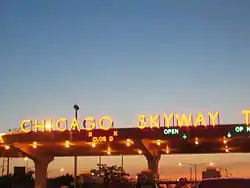
(Calumet Skyway) | The Skyway angles off from the Dan Ryan Expressway near 66th Street and heads southeast toward Indiana. The Skyway ends after a toll bridge over the Little Calumet River and the Indiana state line, at which point it becomes the Indiana Toll Road. | |
| Tri-State Tollway | Serves as a toll bypass around Chicago. The tollway runs from a combination interchange with the Kingery Expressway and the Bishop Ford Freeway towards an interchange with US 41 just south of the Wisconsin state line. North of the junction with the Edens Spur the Tri-State is signed as I-94; on and south of this it is signed as I-294, the southern part of which is overlaid by I-80. | |
| Kingery Expressway | Located entirely in Lansing, Illinois, this is a three-mile-long expressway running from the interchange with the Bishop Ford Freeway and the Tri-State Tollway to the Illinois/Indiana border. | |
| Lake Shore Drive | A major limited-access highway running along the Lake Michigan shoreline from East 67th Street in southern Chicago to Hollywood Avenue in Chicago's Edgewater neighborhood. For most of its length, Lake Shore Drive is signed as US 41. Portions of Lake Shore Drive were constructed as an expressway. | |
| Elgin Bypass | A five-mile freeway signed as US 20, bypassing Elgin, Illinois. It goes west from the Villa Street interchange, meets IL 25, crosses the Fox River, then meets State Street, McLean Boulevard, and Randall Road before continuing at-grade. | |
| Kingery Highway | From Bensenville, the Kingery Highway heads south 18 miles to just south of the Des Plaines River. It is a multi-lane divided limited-access road with grade-separated portions.[9][10] | |
| Amstutz Expressway | A two-mile expressway located entirely in Waukegan, Illinois. It has only one exit at Grand Avenue. | |
| Elgin–O'Hare Tollway ( | Formerly an unnumbered free expressway, it heads west from IL 83 in Bensenville through Itasca, Roselle, and Schaumburg until terminating at an interchange with U.S. Route 20. Until 2017, the expressway ended at IL 53 in Itasca. A one-mile eastern extension to I-490 is under construction. |
U.S. Routes
| U.S. Routes | Description |
|---|---|
| The two Routes enter through the southeastern part of the city from Indiana with U.S. Route 41, underneath the Chicago Skyway Toll Bridge. At 95th Street, they head west to an intersection with U.S. Route 45 west of the city. There they go north on LaGrange Road to Lake Street, where US 20 turns northwest through Elgin to Iowa. US 12 and US 45 continue north past O'Hare Airport to Des Plaines, where US 12 turns on Rand Road and goes northwest, then north to Wisconsin.[9][10][11] | |
| The route splits off from U.S. Route 41 at Bryn Mawr Avenue by Lake Michigan on the north side of the city. US 14 then recrosses US 41 and eventually exits the city as Caldwell Avenue. | |
| The route originally began downtown and ran west on Ogden Avenue and through the suburbs, continuing through Aurora and on to Iowa. In 1970 the beginning was moved west to Harlem Avenue (Illinois Route 43), where it intersected with US 66.[12][13] | |
| The route enters through the southeastern part of the city from Indiana with U.S. Route 12 and U.S. Route 20, underneath the Chicago Skyway Toll Bridge. At 95th Street, when US 12 and US 20 turn west, it continues north along the lakefront, especially via Lake Shore Drive. US 41 then departs from Lake Shore Drive at Foster Avenue. From Foster Avenue, US 41 continues northwest on Lincoln Avenue, finally exiting Chicago at Devon Avenue into the suburb of Lincolnwood. | |
| The route comes north from Kentucky and intersects U.S. Route 12 and U.S. Route 20 at 95th Street west of Chicago. The three routes go north on LaGrange Road, then US 12 and US 45 continue north on Mannheim Road past O'Hare Airport and into Des Plaines. Separating from US 12, it follows the Des Plaines River as Des Plaines River Road, then continues north on Milwaukee Avenue towards Wisconsin.[9][10][11] | |
| The route started downtown and followed Ogden Avenue west out of the city, then southwest to Joliet and on to St Louis. Status as a U.S. Route in Illinois was discontinued in 1974 largely due to Interstate 55 paralleling the stretch. Some remnants are signed as historic.[12] |
County roads
Cook County has a modest amount of county roads after plans were made in 2009 to designate many roads on county ownership as a public service.[14]
Only the designated streets in the townships of Lemont, Palos, Orland, Bremen, Lyons (south of the rivers) and Wheeling have the blue pentagon signs that are used to demarcate county roads.
Gallery
 Interstates in Chicago
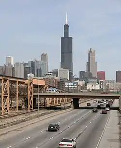 The Eisenhower Expressway at the Ashland Avenue Overpass looking east towards downtown. The 'Ike' as it is known locally, runs parallel to the CTA's Blue Line. Both connect the city to the western suburbs.
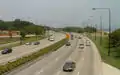 South Lake Shore Drive, looking north towards downtown.
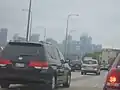 Traffic going southbound on US-41 on a foggy day.
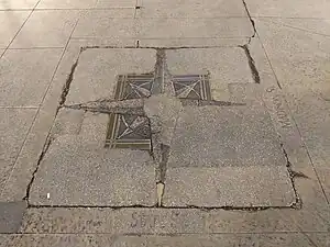 The intersection of Madison St and State St is regarded as the "zero-zero point" of Chicago.
See also
References
- McClendon, Dennis (2005). "Expressways". Encyclopedia of Chicago. University of Chicago Press. Archived from the original on January 2, 2012. Retrieved January 3, 2012.
- "Curious City: Unsung urban planning hero Edward Brennan made it easy to find your way around Chicago". Chicago: WBEZ-FM. May 20, 2015. Archived from the original on May 23, 2015.
- Plan of Re-numbering City of Chicago (PDF). Chicago Directory Company. 1909. Retrieved 2022-06-08.
- "Address Conversion Guide" (PDF). Architecture and Building History. Chicago History Museum. 1911. Archived (PDF) from the original on February 25, 2012. Retrieved January 3, 2012.
- Community Development Department (May 2009). Village of Skokie Street Map (PDF) (Map). Scale not given. Village of Skokie. Archived from the original (PDF) on October 17, 2011. Retrieved March 9, 2012.
- "Chicago Streets Name Changes" (PDF). Architecture and Building History. Chicago History Museum. 1948. Archived (PDF) from the original on July 25, 2011. Retrieved January 3, 2012.
- "Arrangement of City Streets 113-1" (PDF). City of Milwaukee. November 23, 2010. Archived (PDF) from the original on May 8, 2013. Retrieved September 3, 2014.
- "A crash course on the names of Chicago's expressways". WGN-TV. 2022-08-16. Retrieved 2023-10-24.
- Rand McNally (2007). Chicago 7-County Street Guide. Rand McNally. ISBN 978-0-5288-5972-4.
- DeLorme (1996). Illinois Atlas and Gazetteer. Yarmouth, Maine: DeLorme. pp. 20, 21, 28, 29. ISBN 0-89933-213-7.
- "Google Maps". Google Maps. 2013. Retrieved March 14, 2013.
- "Illinois State Highway Maps". Illinois Digital Archives. Retrieved March 14, 2013.
- "US Ends.com". 2012 Dale Sanderson. 2012. Archived from the original on April 7, 2013. Retrieved March 15, 2013.
- "New signs point to confusion". Chicago Tribune. Retrieved January 7, 2023.