Rogers Avenue station
Rogers Avenue station is a Metro SubwayLink station in Baltimore, Maryland. It is located in the Woodmere area, and is the fifth most northern and western station on the line, with approximately 900 parking spaces.[2][3][4]
Rogers Avenue | |||||||||||
|---|---|---|---|---|---|---|---|---|---|---|---|
| Metro SubwayLink station | |||||||||||
 Rogers Avenue station in April 2019 | |||||||||||
| General information | |||||||||||
| Location | 4300 Hayward Avenue Baltimore, Maryland 21215 | ||||||||||
| Owned by | Maryland Transit Administration | ||||||||||
| Platforms | 1 island platform | ||||||||||
| Tracks | 2 | ||||||||||
| Construction | |||||||||||
| Parking | 900 spaces | ||||||||||
| Accessible | Yes | ||||||||||
| History | |||||||||||
| Opened | November 21, 1983 | ||||||||||
| Passengers | |||||||||||
| 2017 | 2,118 daily[1] | ||||||||||
| Services | |||||||||||
| |||||||||||
Station layout
| P Platform level |
Westbound | ← Metro SubwayLink toward Owings Mills (Reisterstown Plaza) |
| Island platform | ||
| Eastbound | Metro SubwayLink toward Johns Hopkins Hospital (West Cold Spring) → | |
| M | Mezzanine | Fare control, ticket machines, station agent |
| G | Street level | Exit/entrance, buses, parking |
Station features
The station has been included in the MTA's 2021 digital signage pilot.[5]
Artwork
The station features a sculpture entitled "Weathering Steel" by Greg Moring.[6]
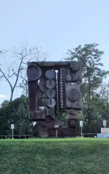
Weathering Steel by Greg Moring
Nearby attractions
- Baltimore City District Court
- Hilltop Shopping Center
- Jewish Community Center of Greater Baltimore
- MTA Offices
- Northwest Plaza
- Pimlico Race Course
References
- https://s3.amazonaws.com/mta-website-staging/mta-website-staging/files/Transit%20Projects/Cornerstone/MSCP_MetroSubwayLink.pdf
- Maryland Transit Administration Archived 2008-01-23 at the Wayback Machine
- Urban Renewal Plan: Rogers Avenue Station Urban Renewal Area (PDF) (Report). Baltimore City Department of Housing and Community Development. April 5, 1983. Retrieved October 27, 2021.
- Central Maryland TOD Strategy (PDF) (Report). Central Maryland Transportation Alliance. July 20, 2009. Retrieved October 27, 2021.
- Luczak, Marybeth (July 6, 2021). "Transit Briefs: Metrolinx, MDOT MTA, UTA, VIA Rail". Railway Age. Retrieved October 27, 2021.
- Rogers Avenue Station - Station Concept Area: Transit-Oriented Development (TOD) Design Guidelines (PDF) (Report). Maryland Transit Administration. January 23, 2020. Retrieved October 27, 2021.
External links
Wikimedia Commons has media related to Rogers Avenue station.
This article is issued from Wikipedia. The text is licensed under Creative Commons - Attribution - Sharealike. Additional terms may apply for the media files.