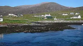
Roineabhal
Roineabhal is a hill in Harris, in the Western Isles of Scotland. The granite on the summit plateau of the mountain is anorthosite, and is similar in composition to rocks found in the mountains of the Moon.[1]
| Roineabhal | |
|---|---|
 Roineabhal with Leverburgh in the foreground | |
| Highest point | |
| Elevation | 460 m (1,510 ft) |
| Prominence | 406 m (1,332 ft) |
| Parent peak | Beinn Dhubh |
| Listing | Marilyn |
| Geography | |
| Location | Harris, Outer Hebrides, Scotland |
| OS grid | NG042860 |
| Topo map | OS Landranger 18 |
The area is part of the South Lewis, Harris and North Uist National Scenic Area.[2]
It is the site of the original Lingerbay 'superquarry' planning application, submitted in 1991 and finally withdrawn in 2004.[2]
References
- McKirdy, Alan Gordon, John & Crofts, Roger (2007) Land of Mountain and Flood: The Geology and Landforms of Scotland. Edinburgh. Birlinn. ISBN 978-1-84158-357-0
Footnotes
- McKirdy et al. (2007) page 94.
- "Superquarry Briefing". Alastair McIntosh. Retrieved 30 August 2009.
This article is issued from Wikipedia. The text is licensed under Creative Commons - Attribution - Sharealike. Additional terms may apply for the media files.