List of Roman canals
This is a list of Roman canals. Roman canals were typically multi-purpose structures, intended for irrigation, drainage, land reclamation, flood control and navigation where feasible. This list focuses on the larger canals, particularly navigational canals, as recorded by ancient geographers and still traceable by modern archaeology. Channels which served the needs of urban water supply are covered at the List of aqueducts in the Roman Empire.


Greek engineers were the first to use canal locks, by which they regulated the water flow in the Ancient Suez Canal as early as the 3rd century BC.[1][2][3] The Romans under Trajan too secured the entrance to the Red Sea with sluice gates, while they extended the canal south to the height of modern Cairo in order to improve its water inflow.[4] The existence of ancient pound locks to bridge height gaps has been proposed by a number of authors,[2][5][6] but in the absence of clear archaeological evidence the question seems to be permanently undecided.[7]
Canals
By chronological order:
Italy
| Construction date | Connection | Canal type | Comment | Refs. |
|---|---|---|---|---|
| 2nd century BC | South of line Modena–Parma | Drainage | Built by Marcus Aemilius Scaurus to drain lower Po area | [8] |
| 2nd century BC | Bologna, Piacenza and Cremona areas | Drainage | Built by Marcus Aemilius Lepidus to drain lower Po area | [8] |
| 1st century BC | Forum Appii–Terracina | Drainage | For dewatering Pomptine Marshes; navigated when Via Appia unusable by mule-towing | [8][9][10] |
| Late 1st century BC | Ferrara–Padua | Inland to coast | Built by Augustus to link Ravenna and Po estuary (Fossa Augusta) | [8] |
| Before late 1st century AD | Fossa Flavia, Fossa Carbonaria, Fossa Philistina, Fossa Clodia | Drainage | According to Pliny the Elder for draining Po estuary; erosion and siltation renders modern identification impossible | [8][9] |
Gaul
| Construction date | Connection | Canal type | Comment | Refs. |
|---|---|---|---|---|
| 101 BC | Rhone–Fos-sur-Mer (Fossa Mariana) | Inland to coast | Built by Marius across Crau plain for supplying his positions around Arles in his campaign against Teutons | [8][9][10] |
| ? | Narbonne–Aude | Inland to coast | Made Narbonne accessible from Mediterranean; 13 km long | [8] |
Germania
| Construction date | Connection | Canal type | Comment | Refs. |
|---|---|---|---|---|
| 12 BC | Rhine–IJssel (Fossa Drusiana) | Inland to coast | For quick deployment of troops to the Frisian coast, avoiding the dangerous passage on the North Sea off the mouth of the Rhine; 14 km long | [8][9][10] |
| c. 9 BC | Rhine dyke | Inland | Built by Drusus the Elder to retain sufficient water to navigate his Fossa Drusiana; demolished by revolting Civilis in 70 AD | [8] |
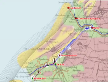
| 47 AD | Rhine–Meuse (Fossa Corbulonis) | Inland | Allowed to navigate both rivers without sailing into North Sea; c. 35 km long | [8][10] |
Britain
| Construction date | Connection | Canal type | Comment | Refs. |
|---|---|---|---|---|
| c. 1st century AD | River Cam–River Ouse (Car Dyke) | Drainage | Land reclamation in Fenland; also navigated | [8] |
| ? | River Ouse–River Nene | Drainage | [8] | |
| ? | River Nene–River Witham | ? | [8] | |
| ? | River Witham–River Trent | ? | Foss Dyke still in use | [8] |
| ? | Bourne-Morton Canal | Navigation | [11] | |
Egypt
| Construction date | Connection | Canal type | Comment | Refs. |
|---|---|---|---|---|
| No later than 112 AD | Nile–Red Sea (Ancient Suez Canal) | Inland to coast | As the older Ptolemaic channel, which was the first to use locks,[12] Trajan's canal linked Mediterranean and Red Sea not directly, but via the Nile. Unlike the Greek channel, though, which branched off the Pelusiac arm, the Roman canal started off the main branch of the Nile at Babylon, 60 km to the south. It joined the Ptolemaic dyke at Belbeis, eventually discharging into the Gulf of Suez at Arsinoe. | [13] |
Moesia
| Construction date | Connection | Canal type | Comment | Refs. |
|---|---|---|---|---|
| 101 AD | Danube bypass canal | Inland | To safely negotiate the cataracts of the Iron Gate; once traceable on Serbian bank (Sip) on a length of 3,220 m | [14][15] |
| 2nd–6th century AD | Danube bypass canal | Inland | According to Procopius for allowing the safe passage past the remains of Trajan's Bridge which obstructed river navigation; dug on Serbian side (Kladovo) | [16] |
Projected canals
In the following, Roman canal projects which were never completed for various reasons are listed.
| Planning date | Connection | Canal type | Comment | Refs. |
|---|---|---|---|---|
| c. 54–68 AD | Rome–Ostia | Inland to coast | Planned by Nero | [8] |
| c. 54–68 AD | Puteoli–Ostia | Inland to coast | Starting from Lake Avernus near Puteoli, it was intended by Nero to run parallel to Mediterranean; length upon completion would have been 160 Roman miles | [8] |
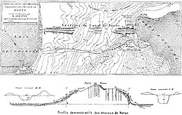
| c. 54–68 AD | Isthmus of Corinth (modern Corinth Canal) | Coast to coast | To avoid long and dangerous circumnavigation of the Peloponnese peninsula; several abandoned building projects in antiquity aimed at replacing Diolkos trackway; serious work begun by Nero, but aborted after his death | [8][9][10] |
| 55 AD | Saône–Moselle (modern Canal de l'Est) | Inland | Another ambitious project: would have connected Mediterranean Sea with North Sea via Rhone, Saône, Moselle and Rhine; presupposes capacity to construct pound locks though, for which there is as yet no certain evidence; yet, plan finally dropped not due to technological reasons, but political intrigues | [8][9][10] |
| 111 AD | Lake Sapanca–Sea of Marmara | Inland to coast | For facilitating transfer of inland produce to seaside; subject of correspondence between governor Pliny the Younger and emperor Trajan; would have required to overcome difference in height of 32 m | [8][9][10][17] |
See also
References
- Moore 1950, pp. 99–101
- Froriep 1986, p. 46
- Schörner 2000, pp. 33–35
- Schörner 2000, pp. 36
- Moore 1950, pp. 98ff.
- Schörner 2000, pp. 39
- Wikander 2000, p. 326
- White 1984, pp. 227–229, table 6
- Wikander 2000, pp. 328–330
- Grewe 2008, pp. 333–336
- D.Trimble (1993), Excavation of a section of the Bourne-Morton canal in Morton Fen., Annual Report, Heritage Trust of Lincolnshire, pp. 29, 30
- Schörner 2000, pp. 33f.
- Schörner 2000, pp. 36f.
- Tudor 1974, p. 38
- Serban 2009, p. 333
- Tudor 1974, pp. 68f., 80
- Froriep 1986, pp. 39–50
Sources
- Froriep, Siegfried (1986): "Ein Wasserweg in Bithynien. Bemühungen der Römer, Byzantiner und Osmanen", Antike Welt, 2nd Special Edition, pp. 39–50
- Grewe, Klaus (2008): "Tunnels and Canals", in: Oleson, John Peter (ed.): The Oxford Handbook of Engineering and Technology in the Classical World, Oxford University Press, pp. 319–336, ISBN 978-0-19-518731-1
- Moore, Frank Gardner (1950): "Three Canal Projects, Roman and Byzantine", American Journal of Archaeology, Vol. 54, No. 2, pp. 97–111
- Schörner, Hadwiga (2000): "Künstliche Schiffahrtskanäle in der Antike. Der sogenannte antike Suez-Kanal", Skyllis, Vol. 3, No. 1, pp. 28–43
- Serban, Marko (2009): "Trajan’s Bridge over the Danube", The International Journal of Nautical Archaeology, Vol. 38, No. 2, pp. 331–342
- Tudor, D. (1974): Les ponts romains du Bas-Danube, Bibliotheca Historica Romaniae Études, Vol. 51, Bucharest: Editura Academiei Republicii Socialiste România, pp. 47–134
- White, K. D. (1984): Greek and Roman Technology, London: Thames and Hudson, pp. 110–112; 227–229, table 6
- Wikander, Charlotte (2000): "Canals", in Wikander, Örjan (ed.): Handbook of Ancient Water Technology, Technology and Change in History, Vol. 2, Leiden: Brill, pp. 321–330, ISBN 90-04-11123-9
Further reading
- Redmount, Carol A. (1995): "The Wadi Tumilat and the 'Canal of the Pharaohs'", Journal of Near Eastern Studies, Vol. 54, No. 2, pp. 127–135
- Smith, N.A.F. (1977/78): "Roman Canals", Transactions of the Newcomen Society, Vol. 49, pp. 75–86
External links
- Livius.org: Fossa Drusiana
- Livius.org: Fossa Corbulonis
- Telegraph.co.uk: 'Biggest Canal Ever Built by Romans' Discovered