Rombo District, Kilimanjaro
Rombo is one of the seven districts of the Kilimanjaro Region of Tanzania. The district covers an area of 1,471 km2 (568 sq mi).[1] It is bordered to the north and east by Kenya, to the west by the Siha District and Hai District, and to the south by the Moshi Rural District. The Rombo District contains a large portion of Kilimanjaro National Park.[2] According to the 2012 census, the population of the Rombo District was 260,963.[3]
Rombo
| |
|---|---|
| Wilaya ya Rombo, Mkoa wa Kilimanjaro | |
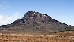 Mawenzi Peak in Rombo District | |
| Nickname: Kili Sunrise | |
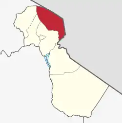 Rombo District in Kilimanjaro Region 2022 | |
| Coordinates: 3°20′34.8″S 37°21′2.52″E | |
| Country | Tanzania |
| Region | Kilimanjaro Region |
| Named for | King Orombo |
| Capital | Moshi |
| Area | |
| • Total | 1,471 km2 (568 sq mi) |
| Highest elevation | 5,895 m (19,341 ft) |
| Population (2012) | |
| • Total | 260,963 |
| • Density | 180/km2 (460/sq mi) |
| Demonym | Romboan |
| Ethnic groups | |
| • Settler | Swahili |
| • Native | Chaga |
| Tanzanian Postal Code | 25-7 |
| Website | District website |
Administrative subdivisions
Wards
Rombo is divided administratively into 24 wards:
|
|
|
Culture and food
Being chagga the population is well know food like Mtori and Kisusio a blood drink made from animal blood and soup. Also the blood is sometime made into a source, famously known as Rombo source
Health
In Terms of Healthcare facilities, as of 2022 Rombo district is home to 6 health centers and 37 clinics.[4]
References
- "Tanzania: Northern Tanzania (Districts and Wards) – Population Statistics, Charts and Map".
- Map, Study Area: Kilimanjaro Region, Local Knowledge & Climate Change Adaptation Project
- Population Distribution by Administrative Units, United Republic of Tanzania, 2013 Archived 2013-05-02 at the Wayback Machine
- "Health Rombo District Council". Retrieved 2022-06-14.