Rubene Parish
Rubene Parish | |
|---|---|
 Coat of arms | |
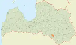 | |
| Country | Latvia |
| Area | |
| • Total | 182.14 km2 (70.32 sq mi) |
| • Land | 179.1 km2 (69.2 sq mi) |
| • Water | 3.04 km2 (1.17 sq mi) |
| Population (1 January 2023)[2] | |
| • Total | 772 |
| • Density | 4.2/km2 (11/sq mi) |
Rubene Parish (Latvian: Rubenes pagasts) is an administrative territorial entity of Jēkabpils Municipality, Latvia. It was an administrative unit of the Jēkabpils District. The administrative center is Rubeņi.
Towns, villages and settlements of Rubene Parish
- Kaldabruņa
- Rubeņi
- Slate
Gallery
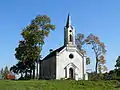 Lutheran church
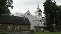 Catholic church
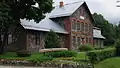 Rubene schoolhouse
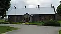 Local government building
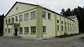 House of culture
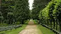 Park
Park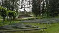 Singing square
External links
Wikimedia Commons has media related to Rubene parish.
- "Reģionu, novadu, pilsētu un pagastu kopējā un sauszemes platība gada sākumā". Central Statistical Bureau of Latvia. Retrieved 18 January 2023.
- "Iedzīvotāju skaits pēc tautības reģionos, pilsētās, novados, pagastos, apkaimēs un blīvi apdzīvotās teritorijās gada sākumā (pēc administratīvi teritoriālās reformas 2021. gadā) 2021 - 2022". Central Statistical Bureau of Latvia. Retrieved 2 October 2023.
This article is issued from Wikipedia. The text is licensed under Creative Commons - Attribution - Sharealike. Additional terms may apply for the media files.